Major County, Oklahoma facts for kids
Quick facts for kids
Major County
|
|
|---|---|
|
|
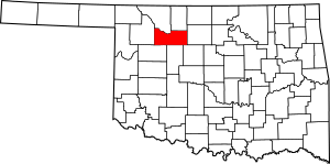
Location within the U.S. state of Oklahoma
|
|
 Oklahoma's location within the U.S. |
|
| Country | |
| State | |
| Founded | 1907 |
| Seat | Fairview |
| Largest city | Fairview |
| Area | |
| • Total | 958 sq mi (2,480 km2) |
| • Land | 955 sq mi (2,470 km2) |
| • Water | 3.0 sq mi (8 km2) 0.3%% |
| Population
(2020)
|
|
| • Total | 7,782 |
| • Density | 8.123/sq mi (3.1364/km2) |
| Time zone | UTC−6 (Central) |
| • Summer (DST) | UTC−5 (CDT) |
| Congressional district | 3rd |
| Website | https://majorcountyok.org/ |
Major County is a special area called a county in the northwestern part of Oklahoma. In 2020, about 7,782 people lived there. The main town, or county seat, is Fairview. Major County was created in 1907.
It is located in northwestern Oklahoma. It shares borders with Woods and Alfalfa counties to the north. To the east is Garfield County. To the south are Kingfisher, Blaine, and Dewey counties. Woodward County is to the west. Major County covers about 958 square miles of land and water. Rivers like the North Canadian and Cimarron flow through it. There are also creeks such as Eagle Chief, Griever, and Sand Creeks.
Contents
History of Major County
Major County was formed in 1907 when Oklahoma became a state. It was made from the southern part of a larger area. Fairview became the county seat. People had settled in Fairview after the Land Run of 1893. Voters chose Fairview as the county seat again in 1908.
The county first rented offices. Later, a brick courthouse was built. A second courthouse, made of stone, was built in 1928. The county is named after John Charles Major. He was a representative at Oklahoma's 1906 Constitutional Convention. Many Mennonite families from Kansas first settled here. One town, Meno, is named after Menno Simons. He was an early leader of the Mennonite movement.
The county also experienced severe dust storms. One famous event was "Black Sunday" on April 14, 1935.
Geography and Natural Features
Major County covers about 958 square miles. About 955 square miles are land. Only 3 square miles, or 0.3%, are covered by water.
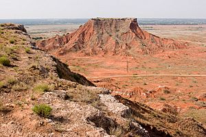
Eagle Chief Creek flows into the Cimarron River near Cleo Springs. The Cheyenne people called this creek Maheonekamax. A large gypsum rock formation is found across western Oklahoma. The Ames Structure is also in the county. It is buried deep underground. Scientists think it might be from a meteorite impact.
The town of Ringwood is known for growing watermelons. They even have a Watermelon Festival every year!
Major Roads in Major County
Neighboring Counties
- Woods County (northwest)
- Alfalfa County (northeast)
- Garfield County (east)
- Kingfisher County (southeast)
- Blaine County (south)
- Dewey County (southwest)
- Woodward County (west)
People of Major County
| Historical population | |||
|---|---|---|---|
| Census | Pop. | %± | |
| 1910 | 15,248 | — | |
| 1920 | 12,426 | −18.5% | |
| 1930 | 12,206 | −1.8% | |
| 1940 | 11,946 | −2.1% | |
| 1950 | 10,279 | −14.0% | |
| 1960 | 7,808 | −24.0% | |
| 1970 | 7,529 | −3.6% | |
| 1980 | 8,772 | 16.5% | |
| 1990 | 8,055 | −8.2% | |
| 2000 | 7,545 | −6.3% | |
| 2010 | 7,527 | −0.2% | |
| 2020 | 7,782 | 3.4% | |
| U.S. Decennial Census 1790-1960 1900-1990 1990-2000 2010 |
|||
In 2000, there were 7,545 people living in Major County. They lived in 3,046 homes, and 2,208 of these were families. The county had about 8 people per square mile. Most residents (94.96%) were White. Almost everyone (94.7%) spoke English. Some people (4.02%) were Hispanic or Latino and spoke Spanish. A few people also spoke German.
About 31% of homes had children under 18. Most homes (63.7%) were married couples. About 27.5% of homes were not families. The average home had 2.44 people. The average family had 2.92 people.
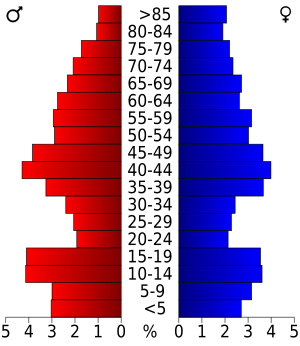
The average age in the county was 42 years old. About 24.7% of people were under 18. About 19.4% were 65 or older. There were slightly more females than males.
Economy and Jobs
Major County's economy has always relied on farming. Farmers grow wheat, raise chickens, and have cattle ranches. Other important crops have included corn, kaffir corn, broomcorn, and alfalfa. Hallren Poultry and Creamery started in Fairview in 1936. By the late 1950s, it was the county's biggest employer.
Oil and gas production also helps the county's economy a lot. This is especially true around the Ames Structure and the Ringwood oil field.
Towns and Places
City
- Fairview (This is the county seat, the main town.)
Towns
Census-designated places
These are special areas that the government counts for population.
Other Unincorporated Places
These are small communities not officially part of a city or town.
Historic Sites
These places in Major County are listed on the National Register of Historic Places. This means they are important historical sites.
- Major County Courthouse, Fairview
- First United Methodist Church, Fairview
Images for kids
See also
 In Spanish: Condado de Major para niños
 | Precious Adams |
 | Lauren Anderson |
 | Janet Collins |


