
Marlboro, Vermont facts for kids
Quick facts for kids
Marlboro, Vermont
|
|
|---|---|

the Marlboro Meeting House Congregational Church (2004)
|
|

Marlboro, Vermont
|
|

Marlboro, Vermont
Location in the United States
|
|
| Country | United States |
| State | Vermont |
| County | Windham |
| Chartered | 1751 |
| Communities |
|
| Area | |
| • Total | 40.7 sq mi (105.3 km2) |
| • Land | 40.3 sq mi (104.5 km2) |
| • Water | 0.3 sq mi (0.8 km2) |
| Elevation | 1,194 ft (364 m) |
| Population
(2020)
|
|
| • Total | 1,722 |
| • Density | 43/sq mi (16.5/km2) |
| Time zone | UTC-5 (Eastern (EST)) |
| • Summer (DST) | UTC-4 (EDT) |
| ZIP Codes | |
| Area code(s) | 802 |
| FIPS code | 50-43375 |
| GNIS feature ID | 1462143 |
Marlboro is a town in Windham County, Vermont, United States. The population was 1,722 people at the 2020 census.
The town is home to the Southern Vermont Natural History Museum. It also has Potash Hill, which used to be the campus for Marlboro College. Each summer, Potash Hill hosts the Marlboro Music School and Festival. It also offers other arts and education programs throughout the year.
Contents
Marlboro's Past: A Look at Its History
Marlboro was first called "New Marlborough." It was named after the Duke of Marlborough. The town received its first official permission, called a "charter," on April 29, 1751. This charter was given to Timothy Dwight and 64 other people from Northampton, Massachusetts.
The French and Indian War stopped people from settling here at first. So, a new charter was given on September 21, 1761. Another one followed on April 17, 1764, still calling it New Marlborough. The town was mapped out in 1762. It was divided into 64 equal parts, except for four lots in the center.
The first settlers arrived in 1763. The town grew quickly between 1764 and 1770. Many people moved here from Massachusetts and Connecticut. By 1799, there were 313 children going to school in the town.
Marlboro's population was highest in 1820, with 1300 people. After that, the number of people went down. This happened because many moved west, and the local economy slowed. Even though the land is mountainous, the soil is very good. This helped farmers grow strong crops. In 1859, almost everyone in the town worked in farming.
The Town Common: Marlboro's Center
The Town Common is a central area in Marlboro. Several important buildings are located here. These include the Town House, built in 1822, which is used for town meetings. There is also the Town Offices and Post Office building, built in 1969. The Marlboro Meeting House Congregational Church, built in 1931, is also on the Common. The Whetstone Inn, built around 1775, is another historic building.
The town's very first church was started in 1776. It was built on top of Town Hill in 1778. In 1820, a new church was built nearby. Wood from the old church was used in 1822 to build the Town House. It was also located close by.
Between 1836 and 1844, both the church and the Town House were moved down the hill. They were placed near their current spots on the Town Common. The church burned down in 1931. The current church was then built. It looks much like the old one, but it is a bit smaller.
After its move down the hill, the Town House was on the east side of South Road. In 1966, a large snow plow hit it. So, it was moved across the road to where it stands today.
The Whetstone Inn was built around 1775 by Deacon Jonas Whitney. He came to Marlboro in 1773. Over the years, this building has been used for many things. It was a courthouse, a church, a tavern, a dance hall, and even a post office.
Marlboro in the 20th and 21st Centuries
In 1946, Marlboro College was started. It was built on the land of three farms. Walter Hendricks founded it for World War II veterans. The famous poet Robert Frost was one of its first leaders. The Marlboro Music School and Festival began in 1951. It takes place every summer on the Potash Hill campus.
In 2011, Hurricane Irene caused flooding. Marlboro was one of thirteen Vermont towns that became cut off by the floods.
| Historical population | |||
|---|---|---|---|
| Census | Pop. | %± | |
| 1790 | 629 | — | |
| 1800 | 1,087 | 72.8% | |
| 1810 | 1,245 | 14.5% | |
| 1820 | 1,296 | 4.1% | |
| 1830 | 1,218 | −6.0% | |
| 1840 | 1,027 | −15.7% | |
| 1850 | 896 | −12.8% | |
| 1860 | 741 | −17.3% | |
| 1870 | 665 | −10.3% | |
| 1880 | 553 | −16.8% | |
| 1890 | 495 | −10.5% | |
| 1900 | 448 | −9.5% | |
| 1910 | 442 | −1.3% | |
| 1920 | 300 | −32.1% | |
| 1930 | 255 | −15.0% | |
| 1940 | 225 | −11.8% | |
| 1950 | 311 | 38.2% | |
| 1960 | 347 | 11.6% | |
| 1970 | 592 | 70.6% | |
| 1980 | 695 | 17.4% | |
| 1990 | 924 | 32.9% | |
| 2000 | 978 | 5.8% | |
| 2010 | 1,078 | 10.2% | |
| 2020 | 1,722 | 59.7% | |
| U.S. Decennial Census | |||
Marlboro's Geography
Marlboro covers about 40.7 square miles (105.3 km2) in total. Most of this area is land, about 40.3 square miles (104.5 km2). A small part, 0.3 square miles (0.8 km2), is water.
Several waterways flow through Marlboro. These include the western branch of the West River, Whetstone Brook, and the Green River.
Vermont Route 9 also crosses through the town. This road is also known as the "Molly Stark Trail."
Marlboro's People
In 2000, there were 978 people living in Marlboro. There were 330 households and 215 families. The town had about 24.3 people per square mile (9.4/km2).
About 30.6% of households had children under 18 living with them. Most households (55.8%) were married couples. About 10.0% of households had someone aged 65 or older living alone.
The average age of people in Marlboro was 37 years old. About 19.0% of the population was under 18. About 23.3% were between 18 and 24 years old.
Learning in Marlboro
Students from kindergarten through eighth grade go to Marlboro School. This school opened in 1954. It replaced several smaller, one-room schoolhouses.
Media in Marlboro
Marlboro is home to the radio station WRSY-FM, which broadcasts at 101.5.
Places to Visit
- Marlboro Historical Society & Museum
- Southern Vermont Natural History Museum
Notable People from Marlboro
- Pete Bernhard, a musician in the band The Devil Makes Three
- Newel Knight, a religious leader
- Richard Lewontin, a biologist
- Margaret MacArthur, a folk historian and musician
- Joseph Mazur, a mathematics professor
- Louis Moyse, a flute player and composer
- Blanche Honegger Moyse, a conductor
- Edson B. Olds, a U.S. Congressman
- Tasha Tudor, an author and illustrator of children's books
- Newel K. Whitney, a businessman and leader in the Church of Jesus Christ of Latter-day Saints
Images for kids
-
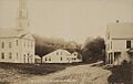
The Town Common in 1908
-
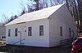
The Town House, used for town meetings, was built in 1822, and later moved to its current location
-
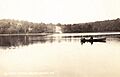
South Pond in 1908
-
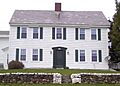
The Colonel Williams Inn, on the Molly Stark Trail (State Route 9) was built around 1769
-

The Whetstone Inn, on the Town Common, was built around 1775


See also
 In Spanish: Marlboro (Vermont) para niños
