Marshall County, Iowa facts for kids
Quick facts for kids
Marshall County
|
|
|---|---|

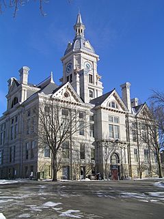
The courthouse in Marshalltown is on the NRHP
|
|

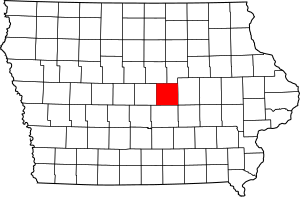
Location within the U.S. state of Iowa
|
|
 Iowa's location within the U.S. |
|
| Country | |
| State | |
| Founded | 1846 |
| Named for | John Marshall |
| Seat | Marshalltown |
| Largest city | Marshalltown |
| Area | |
| • Total | 573 sq mi (1,480 km2) |
| • Land | 572 sq mi (1,480 km2) |
| • Water | 0.7 sq mi (2 km2) 0.1% |
| Population
(2020)
|
|
| • Total | 40,105 |
| • Estimate
(2023)
|
40,014 |
| • Density | 69.99/sq mi (27.024/km2) |
| Time zone | UTC−6 (Central) |
| • Summer (DST) | UTC−5 (CDT) |
| Congressional district | 1st |
Marshall County is a place in the state of Iowa, USA. As of 2020, about 40,105 people lived there. The biggest city and the county's main office location is Marshalltown.
Marshall County was created on January 13, 1846. It was named after John Marshall. He was a very important judge, known as the Chief Justice of the United States Supreme Court. In 2010, the very center of Iowa's population was found in Marshall County, near a town called Melbourne.
Contents
Exploring Marshall County's Location
Marshall County covers a total area of about 573 square miles. Most of this area, about 572 square miles, is land. Only a tiny part, about 0.7 square miles, is water.
How to Get Around
- Marshalltown Municipal Transit
Main Roads in Marshall County
 US 30
US 30 Iowa 14
 Iowa 96
 Iowa 146
 Iowa 330
Neighboring Counties
Marshall County shares borders with several other counties:
- To the South: Jasper County
- To the East: Tama County
- To the West: Story County
- To the Northwest: Hardin County
- To the North: Grundy County
Who Lives in Marshall County?
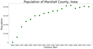
The number of people living in Marshall County has changed over many years.
| Historical population | |||
|---|---|---|---|
| Census | Pop. | %± | |
| 1850 | 338 | — | |
| 1860 | 6,015 | 1,679.6% | |
| 1870 | 17,576 | 192.2% | |
| 1880 | 23,752 | 35.1% | |
| 1890 | 25,842 | 8.8% | |
| 1900 | 29,991 | 16.1% | |
| 1910 | 30,279 | 1.0% | |
| 1920 | 32,630 | 7.8% | |
| 1930 | 33,727 | 3.4% | |
| 1940 | 35,406 | 5.0% | |
| 1950 | 35,611 | 0.6% | |
| 1960 | 37,984 | 6.7% | |
| 1970 | 41,076 | 8.1% | |
| 1980 | 41,652 | 1.4% | |
| 1990 | 38,276 | −8.1% | |
| 2000 | 39,311 | 2.7% | |
| 2010 | 40,648 | 3.4% | |
| 2020 | 40,105 | −1.3% | |
| 2023 (est.) | 40,014 | −1.6% | |
| U.S. Decennial Census 1790-1960 1900-1990 1990-2000 2010-2018 |
|||
Population in 2020
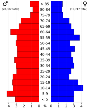
In 2020, the county had 40,105 people. This means there were about 70 people living in each square mile. Most people (90.76%) said they belonged to one race. There were 16,745 homes, and 15,358 of them were lived in.
Here's a look at the different groups of people in Marshall County in 2020:
| Race | Number of People | Percentage |
|---|---|---|
| White | 27,438 | 68.42% |
| Black or African American | 785 | 2% |
| Native American | 153 | 0.4% |
| Asian | 1,514 | 3.8% |
| Pacific Islander | 33 | 0.08% |
| Other/Mixed | 1,042 | 2.6% |
| Hispanic or Latino | 9,140 | 22.8% |
Population in 2010
The 2010 census counted 40,648 people in Marshall County. There were about 71 people per square mile. The county had 16,831 homes, and 15,538 of them were occupied.
Towns and Communities
Marshall County has several towns and communities.
Cities in Marshall County
Special Community Areas
- Green Mountain is a "census-designated place." This means it's a community that the census bureau tracks, but it's not officially a city or town.
Other Small Communities
These are smaller places that are not officially cities or towns:
County Townships
Counties are often divided into smaller areas called townships. Here are the townships in Marshall County:
- Bangor
- Eden
- Greencastle
- Iowa
- Jefferson
- Le Grand
- Liberty
- Liscomb
- Logan
- Marietta
- Marion
- Marshall
- Minerva
- State Center
- Taylor
- Timber Creek
- Vienna
- Washington
Ranking of Communities by Population (2020)
This table shows the cities and communities in Marshall County, ranked by how many people lived there in 2020.
† This symbol means it's the county seat, where the main county offices are located.
| Rank | City/Town/etc. | Type of Community | Population (2020 Census) |
|---|---|---|---|
| 1 | † Marshalltown | City | 27,591 |
| 2 | State Center | City | 1,391 |
| 3 | Le Grand (partially in Tama County) | City | 905 |
| 4 | Melbourne | City | 786 |
| 5 | Gilman | City | 542 |
| 6 | Albion | City | 448 |
| 7 | Liscomb | City | 291 |
| 8 | Rhodes | City | 271 |
| 9 | Laurel | City | 220 |
| 10 | Haverhill | City | 165 |
| 11 | Clemons | City | 140 |
| 12 | Green Mountain | CDP | 113 |
| 13 | Ferguson | City | 97 |
| 14 | St. Anthony | City | 76 |
See also
 In Spanish: Condado de Marshall (Iowa) para niños


