Marshall County, Minnesota facts for kids
Quick facts for kids
Marshall County
|
|
|---|---|

|
|

Location within the U.S. state of Minnesota
|
|
 Minnesota's location within the U.S. |
|
| Country | |
| State | |
| Founded | February 25, 1879 |
| Named for | William Rainey Marshall |
| Seat | Warren |
| Largest city | Warren |
| Area | |
| • Total | 1,813 sq mi (4,700 km2) |
| • Land | 1,775 sq mi (4,600 km2) |
| • Water | 38 sq mi (100 km2) 2.1%% |
| Population
(2020)
|
|
| • Total | 9,040 |
| • Estimate
(2023)
|
8,810 |
| • Density | 5.1/sq mi (2.0/km2) |
| Time zone | UTC−6 (Central) |
| • Summer (DST) | UTC−5 (CDT) |
| Congressional district | 7th |
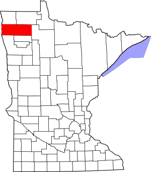
Marshall County is a county located in the northwestern part of the U.S. state of Minnesota. It's a place with lots of open land, perfect for farming. As of the 2020 census, about 9,040 people lived here. The main town and county seat (where the county government is) is Warren.
Contents
History
Marshall County was officially created by the Minnesota government on February 25, 1879. It was formed from the southern part of Kittson County. The town of Warren was also planned out that same year and became the county seat.
The county was named after William Rainey Marshall. He was an important person who served as the governor of Minnesota from 1866 to 1870.
In 1979, Marshall County was the site of a famous UFO event. It's known as the Val Johnson incident.
Geography
Marshall County is right on Minnesota's border with North Dakota. The Red River flows north along the county's western edge, separating it from North Dakota.
Several rivers flow through Marshall County. The Snake River starts in Polk County and flows north through the western part of Marshall County. The Tamarac River begins in Marshall County and flows west through the northern area. The Middle River also starts in Marshall County and flows west through the southern part. All these rivers eventually join the Red River.
The land in the county has gentle, rolling hills and many river valleys. Most of the land is used for farming. The highest point in the county is about 1,194 feet (364 meters) above sea level, located near the middle of its eastern border. Marshall County covers about 1,813 square miles (4,696 square kilometers). Most of this is land, with a small part (about 2.1%) being water.
Marshall is one of 17 counties in Minnesota where "savanna soils" are common. These soils are typical of grasslands with scattered trees.
Major Highways
 U.S. Highway 59
 U.S. Highway 75
 Minnesota State Highway 1
 Minnesota State Highway 32
 Minnesota State Highway 89
 Minnesota State Highway 219
 Minnesota State Highway 220
 Minnesota State Highway 317
Airports
- Stephen Municipal Airport (D41) - located northeast of Stephen
Neighboring Counties
- Kittson County - to the north
- Roseau County - to the northeast
- Beltrami County - to the east
- Pennington County - to the southeast
- Polk County - to the south
- Grand Forks County, North Dakota - to the southwest
- Walsh County, North Dakota - to the west
- Pembina County, North Dakota - to the northwest
Protected Areas
- Agassiz National Wildlife Refuge
- Florian Park
- Florian State Wildlife Management Area
- Old Mill State Park
Lakes
- Thief Lake
- Webster Creek Pool
Demographics
Demographics is the study of a population's characteristics, like age, gender, and race. Here's how Marshall County's population has changed over the years:
| Historical population | |||
|---|---|---|---|
| Census | Pop. | %± | |
| 1880 | 992 | — | |
| 1890 | 9,130 | 820.4% | |
| 1900 | 15,698 | 71.9% | |
| 1910 | 16,338 | 4.1% | |
| 1920 | 19,443 | 19.0% | |
| 1930 | 17,003 | −12.5% | |
| 1940 | 18,364 | 8.0% | |
| 1950 | 16,125 | −12.2% | |
| 1960 | 14,262 | −11.6% | |
| 1970 | 13,060 | −8.4% | |
| 1980 | 13,027 | −0.3% | |
| 1990 | 10,993 | −15.6% | |
| 2000 | 10,155 | −7.6% | |
| 2010 | 9,439 | −7.1% | |
| 2020 | 9,040 | −4.2% | |
| 2023 (est.) | 8,810 | −6.7% | |
| U.S. Decennial Census 1790-1960 1900-1990 1990-2000 2010-2020 |
|||
2020 Census Information
The 2020 Census helps us understand the different groups of people living in Marshall County.
| Race | Number of People | Percentage |
|---|---|---|
| White | 8,332 | 92.2% |
| Black or African American | 12 | 0.13% |
| Native American | 29 | 0.32% |
| Asian | 19 | 0.21% |
| Pacific Islander | 0 | 0% |
| Other/Mixed Race | 258 | 2.9% |
| Hispanic or Latino | 390 | 4.31% |
Communities
Marshall County has several towns and smaller communities.
Cities
Unincorporated Communities
These are smaller places that are not officially organized as cities or towns.
Townships
Townships are smaller local government areas within the county.
- Agder Township
- Alma Township
- Augsburg Township
- Big Woods Township
- Bloomer Township
- Boxville Township
- Cedar Township
- Como Township
- Comstock Township
- Donnelly Township
- Eagle Point Township
- East Park Township
- East Valley Township
- Eckvoll Township
- Espelie Township
- Excel Township
- Foldahl Township
- Fork Township
- Grand Plain Township
- Holt Township
- Huntly Township
- Lincoln Township
- Linsell Township
- Marsh Grove Township
- McCrea Township
- Middle River Township
- Moose River Township
- Moylan Township
- Nelson Park Township
- New Folden Township
- New Maine Township
- New Solum Township
- Oak Park Township
- Parker Township
- Rollis Township
- Sinnott Township
- Spruce Valley Township
- Tamarac Township
- Thief Lake Township
- Valley Township
- Vega Township
- Veldt Township
- Viking Township
- Wanger Township
- Warrenton Township
- West Valley Township
- Whiteford Township
- Wright Township
Unorganized Territory
- Mud Lake
See also
 In Spanish: Condado de Marshall (Minnesota) para niños


