McCracken County, Kentucky facts for kids
Quick facts for kids
McCracken County
|
|
|---|---|

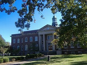
McCracken County courthouse in Paducah
|
|

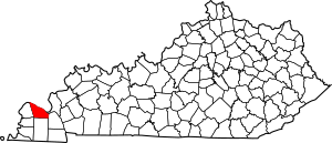
Location within the U.S. state of Kentucky
|
|
 Kentucky's location within the U.S. |
|
| Country | |
| State | |
| Founded | 1825 |
| Named for | Virgil McCracken |
| Seat | Paducah |
| Largest city | Paducah |
| Area | |
| • Total | 268 sq mi (690 km2) |
| • Land | 249 sq mi (640 km2) |
| • Water | 19 sq mi (50 km2) 7.2% |
| Population
(2020)
|
|
| • Total | 67,875 |
| • Estimate
(2023)
|
67,428 |
| • Density | 253.3/sq mi (97.79/km2) |
| Time zone | UTC−6 (Central) |
| • Summer (DST) | UTC−5 (CDT) |
| Congressional district | 1st |
McCracken County is a county located in the far western part of Kentucky, a state in the United States. In 2020, about 67,875 people lived there. The main city and county seat is Paducah.
McCracken County was the 78th county created in Kentucky. It was formed in 1825. This area is part of the historic Jackson Purchase. This land was bought from the Chickasaw people by General Andrew Jackson and Governor Isaac Shelby.
Paducah grew because of its location near rivers and railroads. Steamboats, barges, and the Illinois Central Railroad were very important for the economy for a long time. In the 1920s, the Illinois Central Railroad built a huge base here for operating and fixing trains.
McCracken County is the main county in the Paducah, KY-IL Metropolitan Statistical Area. This means it's the center of a larger urban area that includes parts of Illinois.
Contents
History of McCracken County
McCracken County was created in 1825. It was formed from parts of Hickman County. The county was named after Captain Virgil McCracken. He was from Woodford County, Kentucky. Captain McCracken died in a battle during the War of 1812. This battle was called the Battle of Frenchtown.
A battle from the American Civil War also happened in McCracken County. It was called the Battle of Paducah. This fight took place on March 25, 1864. Union and Confederate soldiers fought here. The Confederate side won this skirmish. About 140 soldiers died during the battle.
Besides river traffic, the railroad also helped the county's economy. Many families had jobs related to the railroad. Men worked as firemen, repairmen, and in other important roles.
Geography and Nature
McCracken County covers about 268 square miles. Most of this area, about 249 square miles, is land. The rest, about 19 square miles, is water.
The northern border of the county is the Ohio River. This river separates Kentucky from Illinois. The northeastern border is formed by the Tennessee River.
Neighboring Counties
McCracken County shares borders with several other counties:
- Massac County, Illinois (to the north)
- Livingston County (to the northeast)
- Marshall County (to the east)
- Graves County (to the south)
- Carlisle County (to the southwest)
- Ballard County (to the west)
Protected Natural Areas
Part of the Clarks River National Wildlife Refuge is located in McCracken County. This refuge helps protect wildlife and their homes.
People of McCracken County
| Historical population | |||
|---|---|---|---|
| Census | Pop. | %± | |
| 1830 | 1,297 | — | |
| 1840 | 4,745 | 265.8% | |
| 1850 | 6,067 | 27.9% | |
| 1860 | 10,360 | 70.8% | |
| 1870 | 13,988 | 35.0% | |
| 1880 | 16,262 | 16.3% | |
| 1890 | 21,051 | 29.4% | |
| 1900 | 28,733 | 36.5% | |
| 1910 | 35,064 | 22.0% | |
| 1920 | 37,246 | 6.2% | |
| 1930 | 46,271 | 24.2% | |
| 1940 | 48,534 | 4.9% | |
| 1950 | 49,137 | 1.2% | |
| 1960 | 57,306 | 16.6% | |
| 1970 | 58,281 | 1.7% | |
| 1980 | 61,310 | 5.2% | |
| 1990 | 62,879 | 2.6% | |
| 2000 | 65,514 | 4.2% | |
| 2010 | 65,565 | 0.1% | |
| 2020 | 67,875 | 3.5% | |
| 2023 (est.) | 67,428 | 2.8% | |
| U.S. Decennial Census 1790-1960 1900-1990 1990-2000 2010-2020 |
|||
In 2000, there were 65,514 people living in McCracken County. There were 27,736 households and 18,444 families. The county had about 261 people per square mile.
Most people in the county were White (86.76%). About 10.88% were Black or African American. Other groups made up smaller percentages. About 1.06% of the population was Hispanic or Latino.
About 29.60% of households had children under 18 living with them. The average household had 2.31 people. The average family had 2.86 people.
The median age in the county was 39 years old. About 23.40% of the population was under 18. About 15.90% were 65 years or older.
Education in McCracken County
There are two main public school districts in McCracken County:
- McCracken County Public Schools: This district serves most of the county.
- Paducah Public Schools: This district serves the main part of the city of Paducah.
Several private schools also offer education from kindergarten to 12th grade. These include the St. Mary System and Community Christian Academy.
For higher education, students can attend West Kentucky Community and Technical College (WKCTC) in Paducah. This college offers associate degrees. The University of Kentucky also has a branch of its College of Engineering at WKCTC. Murray State University offers bachelor's and master's degree programs. A new building for Murray State opened in 2014 near WKCTC.
Communities in McCracken County
City
- Paducah (the county seat)
Census-Designated Places
These are areas that are like towns but are not officially incorporated as cities.
Unincorporated Communities
These are smaller communities that are not officially part of a city or census-designated place.
- Camelia
- Cecil
- Cimota City
- Freemont
- Future City
- Grahamville
- Hardmoney
- Heath
- Hovekamp
- Krebs
- Lone Oak
- Maxon
- Melber (mostly in Graves County)
- Ragland
- Rossington
- Rudolph
- Saint Johns
- Sheehan Bridge
- West Paducah
See also
In Spanish: Condado de McCracken para niños
 | Frances Mary Albrier |
 | Whitney Young |
 | Muhammad Ali |

