
Melrose, Massachusetts facts for kids
Quick facts for kids
Melrose, Massachusetts
|
|||
|---|---|---|---|

Downtown Melrose
|
|||
|
|||
| Motto(s):
One Community Open to All
|
|||

Location in Middlesex County in Massachusetts
|
|||

Melrose, Massachusetts
Location in the United States
|
|||
| Country | United States | ||
| State | Massachusetts | ||
| County | Middlesex | ||
| Settled | 1629 | ||
| Incorporated | 1850 | ||
| City | 1900 | ||
| Government | |||
| • Type | Mayor-council city | ||
| Area | |||
| • Total | 4.77 sq mi (12.35 km2) | ||
| • Land | 4.68 sq mi (12.13 km2) | ||
| • Water | 0.09 sq mi (0.22 km2) | ||
| Elevation | 133 ft (41 m) | ||
| Population
(2020)
|
|||
| • Total | 29,817 | ||
| • Density | 6,365.71/sq mi (2,458.07/km2) | ||
| Time zone | UTC−5 (Eastern) | ||
| • Summer (DST) | UTC−4 (Eastern) | ||
| ZIP Code |
02176
|
||
| Area code(s) | 339/781 | ||
| FIPS code | 25-40115 | ||
| GNIS feature ID | 0612780 | ||


Melrose is a city in Massachusetts, United States. It's part of the larger Greater Boston area. In 2020, about 29,817 people lived there. Melrose is a suburb located about seven miles north of Boston. It's easy to reach from major highways like I-93, I-95, and U.S. Route 1.
The land where Melrose now stands was first settled in 1628. It was once part of Charlestown and then Malden. It became the Town of Melrose in 1850 and then a city in 1900.
Contents
History of Melrose
_map.jpg)
Melrose was first called "Ponde Fielde" because it had many ponds and streams. It was also known as "Mystic Side" due to its location near the Mystic River. In 1628, explorers Richard and Ralph Sprague visited the area. By 1633, it became part of Charlestown.
In 1649, the area became part of the new town of Malden. This part was called North Malden and was mostly farmland. By 1845, the Boston and Maine Railroad built three train stops here. People who worked in Boston started moving to North Malden for a more rural life. They would travel to work by train.
As more people moved in, North Malden grew. In 1850, it separated from Malden and became the town of Melrose. The name "Melrose" comes from a town in Melrose, Scotland. It was chosen because the hills in the new town looked like the Eildon hills in Scotland. A man named William Bogle, who was from Scotland, suggested the name.
Melrose continued to grow in the late 1800s. Farmland was divided into smaller plots for homes and businesses. The city created a fire department and a school system. The town hall was built in 1873. In 1899, Melrose officially became the 33rd city in Massachusetts. Levi S. Gould became the first mayor on January 1, 1900.
In 1970, Melrose had its largest population with 33,180 residents. Later, in 1982, Downtown Melrose was added to the National Register of Historic Places. The public library was added to the register in 1988.
Famous People from Melrose
Melrose has been home to several notable people:
- Chris Koch – A director for movies and TV shows.
- David Hackett Souter (born 1939) – He was a Supreme Court Justice. He was born in Melrose.
- Elizabeth George Speare (1908-1994) – A famous writer of children's books.
- Sewall Wright (1889-1988) – A well-known geneticist, born in Melrose.
- Keith Tkachuk – A former professional hockey player in the National Hockey League. He scored over 500 goals and won a silver medal at the 2002 Olympics.
Geography of Melrose
Melrose is located at coordinates 42.459045° N, −71.062339° W.
The city covers about 4.8 square miles (12.35 square kilometers). Most of this area is land, with a small part being water. The largest body of water is Ell Pond, which is near the center of the city. Other ponds include Swains Pond and Towners Pond.
Melrose is about 7 miles (11 kilometers) north of Boston. It shares borders with four other cities and towns: Malden, Saugus, Stoneham, and Wakefield. Important natural spots include Ell Pond, Swains Pond, Sewall Woods, Mount Hood, Boston Rock, Pine Banks Park, and parts of the Middlesex Fells Reservation.
Elizabeth George Speare, who grew up in Melrose, once wrote that it was a great place to grow up. She loved being close to fields and woods for hiking and picnics. She also enjoyed being near Boston for theaters and concerts.
Neighborhoods in Melrose
Melrose has several distinct neighborhoods:
- Cedar Park
- Downtown Melrose
- East Side
- Horace Mann
- Melrose Highlands
- Mount Hood
- Oak Grove/Pine Banks
- Wyoming
-

The Gazebo at Ell Pond Park
-
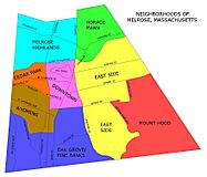
The neighborhoods of Melrose


Population Information
| Historical population | ||
|---|---|---|
| Year | Pop. | ±% |
| 1850 | 1,260 | — |
| 1860 | 2,532 | +101.0% |
| 1870 | 3,414 | +34.8% |
| 1880 | 4,560 | +33.6% |
| 1890 | 8,519 | +86.8% |
| 1900 | 12,962 | +52.2% |
| 1910 | 15,715 | +21.2% |
| 1920 | 18,204 | +15.8% |
| 1930 | 23,170 | +27.3% |
| 1940 | 25,333 | +9.3% |
| 1950 | 26,988 | +6.5% |
| 1960 | 29,619 | +9.7% |
| 1970 | 33,180 | +12.0% |
| 1980 | 30,055 | −9.4% |
| 1990 | 28,150 | −6.3% |
| 2000 | 27,134 | −3.6% |
| 2010 | 26,983 | −0.6% |
| 2020 | 29,817 | +10.5% |
| 2023* | 29,357 | −1.5% |
| * = population estimate. Source: United States Census records and Population Estimates Program data. Source: |
||
In 2010, Melrose had 26,983 people living in 11,213 households. About 28.4% of households had children under 18. The average household size was 2.38 people. The median age in the city was 41.9 years.
Education in Melrose
.jpg)
The Melrose School district manages several schools. These include The Franklin Early Childhood Center for younger children. There are five elementary schools: Roosevelt, Lincoln, Winthrop, Hoover, and Horace Mann. Older students attend Melrose Veterans Memorial Middle School (MVMMS) and Melrose High School.
Melrose also has a private elementary school called St. Mary of the Annunciation. Melrose Veterans Memorial Middle School has won several awards. These include the Massachusetts Department of Education's Compass School Award in 2002 and the Green School Award in 2007 for using solar energy. In 2008, it received the Spotlight School Award from the New England League of Middle Schools.
Transportation in Melrose
Melrose has a short section of Route 99, but it's close to many other major roads. These include Route 1 in Saugus, I-93 in Stoneham, and Route 128/I-95 in Wakefield.
The city also has public transportation provided by the MBTA. There are three bus routes: 131, 132, and 137. Melrose also has three commuter rail stations: Wyoming Hill, Melrose/Cedar Park, and Melrose Highlands. The Oak Grove subway station, which is the last stop on the Orange Line, is located just outside Melrose in Malden.
Media and Filming in Melrose

Melrose has local news sources. The Melrose Weekly News is a weekly newspaper. There is also an online news site called Melrose Patch. Melrose Massachusetts Television (MMTV) is a local cable TV station. It shows community notices and programs made by residents.
Melrose has been a filming location for several movies. In 2009, the Ben Affleck movie The Town filmed scenes in a historic bank downtown. Around the same time, Knight & Day, starring Cameron Diaz and Tom Cruise, filmed scenes on the Fellsway. A PBS documentary about the Scopes Trial was also filmed in Melrose City Hall. More recently, the Apple TV+ movie Spirited (2022) and the Warner Bros. film Beetlejuice Beetlejuice (2023) also filmed scenes in Melrose.
See also
 In Spanish: Melrose (Massachusetts) para niños
