Meringandan facts for kids
Quick facts for kids MeringandanQueensland |
|||||||||||||||
|---|---|---|---|---|---|---|---|---|---|---|---|---|---|---|---|

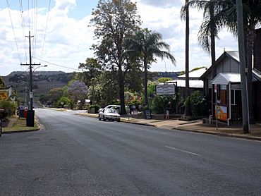
Main Street, 2014
|
|||||||||||||||
| Population | 530 (2021 census) | ||||||||||||||
| • Density | 22.75/km2 (58.9/sq mi) | ||||||||||||||
| Established | 1868 | ||||||||||||||
| Postcode(s) | 4352 | ||||||||||||||
| Area | 23.3 km2 (9.0 sq mi) | ||||||||||||||
| Time zone | AEST (UTC+10:00) | ||||||||||||||
| Location |
|
||||||||||||||
| LGA(s) | Toowoomba Region | ||||||||||||||
| State electorate(s) |
|
||||||||||||||
| Federal Division(s) | Groom | ||||||||||||||
|
|||||||||||||||
Meringandan is a small country area in the Toowoomba Region of Queensland, Australia. It is known as a "locality," which is like a suburb in a rural setting. In 2021, about 530 people lived in Meringandan.
Contents
Exploring Meringandan's Location
Meringandan is located on the Darling Downs, a large farming area in Queensland. It is close to Highfields, and about 19 kilometers (12 miles) north-northwest of Toowoomba.
A winding waterway called Meringandan Creek flows through the area. This creek also used to mark the border between two old local government areas, the Shire of Crows Nest and the Shire of Rosalie. It also separates Meringandan from its neighbor, Meringandan West.
Meringandan's Past: A Look at History
The name "Meringandan" comes from Aboriginal words. "Moorin" means "fire" and "Gandan" means "clay." So, Meringandan means "place of fire and clay."
Early European Settlement
In 1840, the Leslie brothers settled near Warwick. Soon after, in 1841, Henry Hughes and Henry Isaac started a sheep farm called Gowrie. They later expanded their land to include the Meringandan area.
Henry Hughes left the partnership in 1850. Henry Isaac then took over Gowrie and partnered with his brother, Fred Isaac. Fred was very good at managing the farm.
In 1854, Fred married Caroline Sophia Sparkes and returned to Australia to run Gowrie. Henry Isaac sold his share of Gowrie to Fred in 1860 and went back to England. Fred then partnered with Ernest de St Jean de Satgé to help pay for the land.
Sadly, Fred Isaac died in 1865. The farm was sold to George King, whose sons continued to raise sheep and horses.
Land Opening and Growth
A law called the Lands Alienation Act of 1868 opened up the Meringandan part of Gowrie Station for new settlers. Many German farmers moved to Queensland in the 1860s, and some came to the Darling Downs. Many families in Meringandan today have German ancestors. These early settlers were surprised that they had to choose at least 40 acres (about 16 hectares) of land.
The German settlers built a church in 1870. Later, other churches, like the Church of England and the Church of Christ, were also built.
After the land was opened for selection in 1872, the town quickly grew. Shops and hotels, like "The Criterion" and "Farmers Arms," were built. Blacksmiths and butchers were also busy.
Schools and Railways
Meringandan State School opened on January 24, 1876. Jack Maag built it in 1875. Isaac John Thomas was the first head teacher, and 80 students enrolled that year. Today, this school is located in Meringandan West.
A railway line was built from Toowoomba to Cabarlah, and the first train ran in September 1883. Meringandan had a railway station, which was important for farmers in nearby areas like Goombungee and Haden to send their goods.
In the early 1900s, it was common to see a long line of horse-drawn wagons waiting at the station. However, when a new railway line to Haden was built in 1910, and as cars became more common, Meringandan's railway station was used less. After the railway closed, the station was replaced with a park.
Churches and Services
St Gregory's Anglican Church was officially opened on September 12, 1886. It was built on land donated by Mr. Foland near the railway station. The church was 18 by 38 feet (about 5.5 by 11.6 meters) and could seat 150 people. In 1905, this church was moved to Kingsthorpe. It closed around 1982.
On February 2, 1896, a new Lutheran church opened, replacing an older one. This new church was built by L. Goebel and Son. It was 40 by 20 feet (about 12 by 6 meters) with high walls. Inside, it had a raised cedar pulpit.
Around 1900, the Court House was moved from Cabarlah to Meringandan. Before 1900, most farmers' wives baked their own bread. But early in the century, a bakery was started by O. Wuersching.
Brigalow Park Provisional School opened on October 17, 1910, and became Brigalow Park State School in 1912. It closed on April 13, 1962.
Population Changes in Meringandan
The number of people living in Meringandan has changed over the years:
- In 2011, Meringandan had 305 people.
- In 2016, the population grew to 487 people.
- In 2021, Meringandan had a population of 530 people.
Learning in Meringandan
There are no schools directly within Meringandan itself. Students usually go to nearby schools. The closest government primary schools are:
- Meringandan State School in Meringandan West (to the west)
- Geham State School in Geham (to the east)
- Highfields State School in Highfields (to the south-east)
For high school, the closest government secondary school is Highfields State Secondary College in Highfields.
What Meringandan Offers
Meringandan has a few local places for residents:
- A country pub
- A convenience store
- A butcher
There are also two parks where people can relax.
The Toowoomba Regional Council provides library services with a mobile library van. This van visits Meringandan State School and the Meringandan Produce Store every Thursday.
Fun Events and Attractions
Meringandan hosts an annual rodeo, which is a popular event that many people attend.
The area is also known as the gateway to Cooby Dam, a large dam that is a popular spot for fishing and boating.


