
Milk River (Alberta–Montana) facts for kids
Quick facts for kids Milk River |
|
|---|---|

The Milk River in Writing-on-Stone Provincial Park
|
|

The Milk River shown highlighted
|
|
| Countries | United States and Canada |
| State | Montana |
| Province | Alberta |
| Physical characteristics | |
| Main source | Confluence of South and Middle Forks Glacier County, Montana 4,403 ft (1,342 m) 48°51′20″N 113°01′10″W / 48.85556°N 113.01944°W |
| River mouth | Missouri River Valley County, Montana 2,024 ft (617 m) 48°03′26″N 106°19′07″W / 48.05722°N 106.31861°W |
| Length | 729 mi (1,173 km) |
| Basin features | |
| Basin size | 23,800 sq mi (62,000 km2) |
The Milk River is a long river in North America. It flows for about 729 mi (1,173 km). The river is a tributary, which means it flows into a larger river. The Milk River joins the Missouri River.
You can find the Milk River in the U.S. state of Montana and the Canadian province of Alberta. It starts in the Rocky Mountains. The river flows through a dry area called a watershed. This watershed covers about 23,800 sq mi (62,000 km2). The Milk River ends just east of Fort Peck, Montana.
Where the Milk River Flows
The Milk River starts in Glacier County, Montana. This is in northwestern Montana, about 21 miles (34 km) north of Browning, Montana. It forms where two smaller rivers meet: the South Fork and the Middle Fork.
The South Fork is about 30-mile (48 km) long. The Middle Fork is about 20-mile (32 km) long. Both of these forks begin in the Rocky Mountains. They are just east of Glacier National Park. This area is part of the Blackfeet Indian Reservation.
A lot of water in the North Fork of the Milk River comes from the St. Mary River. This water is moved using a special canal and an inverted siphon. An inverted siphon is like a pipe that goes under a dip in the land.
The main part of the Milk River flows east and northeast into southern Alberta, Canada. There, it meets the North Fork of the Milk River. The river then flows past the town of Milk River. It also goes by Writing-on-Stone Provincial Park.
After that, the river turns southeast and flows back into Montana. It runs east along the north side of the Sweetgrass Hills. Then it turns south and passes through the Fresno Dam. It continues east past Havre. It also flows along the north side of the Fort Belknap Indian Reservation.
Near Malta, the river turns north, then southeast. It flows past Glasgow. Finally, it joins the Missouri River in Valley County, Montana. This meeting point is about 5 miles (8 km) downstream from Fort Peck Dam.
The area that drains into the Milk River is called its watershed. This watershed reaches into Alberta and Saskatchewan in Canada. It also covers parts of Montana in the US. The total watershed size is about 61,642 km2 (23,800 sq mi).
- About 6,500 km2 (2,510 sq mi) of the watershed is in Alberta.
- About 14,942 km2 (5,769 sq mi) is in Saskatchewan.
- The rest of the watershed is in Montana.
The parts of the watershed in Alberta and Saskatchewan are actually part of the larger Mississippi River watershed. This means the water from these areas eventually flows into the Mississippi River.
| River | Location | Water Flow |
|---|---|---|
| North Fork Milk River | US-Canada Border | 99 cu ft/s (2.8 m3/s) |
| South Fork Milk River | near Browning | 98 cu ft/s (2.8 m3/s) |
| Milk River | Nashua | 618 cu ft/s (17.5 m3/s) |
How the Milk River Got Its Name
The Milk River got its name from Captain Meriwether Lewis. He was part of the famous Lewis and Clark Expedition. He wrote about the river in his journal.
He said the water had a "peculiar whiteness." He compared it to a cup of tea with a spoonful of milk added. Because of this milky color, they decided to call it the Milk River.
The river looks milky because of tiny bits of clay and silt in its water. These tiny particles come from soft, clay-rich rocks. These rocks are found along the Milk River basin in southern Alberta. Examples include the Foremost, Oldman, and Dinosaur Park formations.

When Lewis explored the area, the Milk River drainage was part of the United States. This was because of the Louisiana Purchase. But in 1818, the US and Britain made a deal. They swapped a portion of the Milk River watershed. This part was north of 49° north latitude. In return, the US received land near the Red River of the North. This land had been part of British North America.
In 1908, the water from the Milk River was part of an important court case. This case went to the Supreme Court of the United States. It helped to make clear the water rights of American Indian reservations. The case is known as Winters v. United States.
Images for kids
-
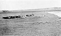
Alberta round-up camp next to river, 1912

See also
 In Spanish: Río Milk para niños
