
Minaret Summit facts for kids
Quick facts for kids Minaret Summit |
|
|---|---|

Mammoth Mountain as viewed from Minaret Summit
|
|
| Elevation | 9,265 ft (2,824 m) |
| Traversed by | |
| Location | Madera / Mono counties, California, United States |
| Range | Sierra Nevada |
| Coordinates | 37°39′23″N 119°03′37″W / 37.65639°N 119.06028°W |
| Topo map | USGS Mammoth Mountain |
Minaret Summit is a high mountain pass in the Sierra Nevada mountains of California. It sits on Highway 203, right on the border between Madera and Mono counties. This beautiful area is part of the Inyo National Forest.
The summit is close to popular spots like Devils Postpile National Monument, Mammoth Lakes, and Mammoth Mountain. It's about 9,265 feet (2,824 meters) high. Highway 203 ends here, but the road continues as Reds Meadow Road, leading to places like Rainbow Falls.
Contents
Protecting Minaret Summit's Wilderness
For a long time, people talked about building a big highway through Minaret Summit. This road would connect the Eastern Sierra to the San Joaquin Valley. There was even a gap left in the Wilderness Act of 1964 just in case this highway was built.
However, many people wanted to protect this natural area. When Ronald Reagan was the Governor of California, he took a trip into the area on horseback. After seeing its beauty, he decided to support efforts to stop the highway.
Later, when Reagan became President, he continued to work on protecting Minaret Summit. Because of these efforts, the area was officially made a protected "wilderness" by the California Wilderness Act of 1984. This means it's a wild, natural place where human activity is limited to preserve its beauty. Now, the Sierra Nevada mountains have a continuous wilderness area stretching for about 150 miles (240 km).
Amazing Views from the Top
Minaret Summit offers incredible views in every direction. If you look to the west, you can see the Ritter Range. This includes the sharp, jagged peaks known as The Minarets, along with Mount Ritter and Banner Peak.
To the east, you'll see the huge Long Valley Caldera, which is a giant volcanic crater. You can also spot the Glass Mountains and the White Mountains. The Middle Fork of the San Joaquin River flows through the valley between the summit and The Minarets.
Winter Snow and Road Closures
Minaret Summit gets a lot of snow during the winter months. Because of the heavy snowfall, the road usually closes near the Main Lodge of Mammoth Mountain Ski Area around Thanksgiving. It typically doesn't open again until Memorial Day in late spring.
A Famous Discovery
In October 2008, some items belonging to a missing adventurer named Steve Fossett were found near Minaret Lake. This lake is in an area that you can see from Minaret Summit. This discovery helped searchers find his remains and his airplane.
Images for kids
-
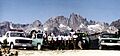
The Minarets behind the Mammoth Ranger District Fire Crew (Inyo National Forest) at Minaret Summit Vista Point circa August 1984. Steve Fossett's remains were found approximately at the spot in the distance behind the leftmost fireman.

