Mount Arlington, New Jersey facts for kids
Quick facts for kids
Mount Arlington, New Jersey
|
||
|---|---|---|
|
Borough
|
||
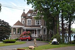
"Castle on the Lake" in Mount Arlington
|
||
|
||
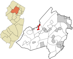
Location of Mount Arlington in Morris County highlighted in red (right). Inset map: Location of Morris County in New Jersey highlighted in orange (left).
|
||
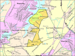
Census Bureau map of Mount Arlington, New Jersey
|
||
| Country | ||
| State | ||
| County | ||
| Incorporated | November 3, 1890 | |
| Named for | Henry Bennet, 1st Earl of Arlington | |
| Government | ||
| • Type | Borough | |
| • Body | Borough Council | |
| Area | ||
| • Total | 2.80 sq mi (7.25 km2) | |
| • Land | 2.14 sq mi (5.55 km2) | |
| • Water | 0.66 sq mi (1.70 km2) 23.30% | |
| Area rank | 356th of 565 in state 28th of 39 in county |
|
| Elevation | 1,079 ft (329 m) | |
| Population
(2020)
|
||
| • Total | 5,909 | |
| • Estimate
(2023)
|
5,931 | |
| • Rank | 350th of 565 in state 30th of 39 in county |
|
| • Density | 2,761.2/sq mi (1,066.1/km2) | |
| • Density rank | 234th of 565 in state 11th of 39 in county |
|
| Time zone | UTC−05:00 (Eastern (EST)) | |
| • Summer (DST) | UTC−04:00 (Eastern (EDT)) | |
| ZIP Code |
07856
|
|
| Area code(s) | 973 | |
| FIPS code | 3402748690 | |
| GNIS feature ID | 0885312 | |
| Website | ||
Mount Arlington is a small town, called a borough, located in western Morris County, in the state of New Jersey. In 2020, about 5,909 people lived here. This was a good increase from the 5,050 people counted in 2010.
The borough is found on the southeast side of Lake Hopatcong. This lake is the biggest in New Jersey and a popular spot for fun activities like boating and swimming. Mount Arlington is also home to the Lake Hopatcong Yacht Club.
Contents
History of Mount Arlington
Mount Arlington used to be a very popular vacation spot. Before cars and airplanes became common, many people came here to relax. They wanted to escape the summer heat of big cities like New York City and Newark.
Thousands of visitors would arrive by train at Landing Station. From there, they would take water taxis across Lake Hopatcong. They stayed at large resort hotels and enjoyed the cool "Mount Arlington breeze." There was even a big amusement park called Bertrand Island. It had a famous carousel and roller coaster, and it stayed open until 1983.
Mount Arlington officially became a borough on November 3, 1890. It was formed from parts of Roxbury Township. The town is named after Henry Bennet, 1st Earl of Arlington.
Geography and Location
Mount Arlington covers about 2.79 square miles (7.23 square kilometers). Most of this area is land, but a good portion is water, making up about 23.30% of the total area.
The borough shares its borders with a few other towns. These include Jefferson Township, New Jersey and Roxbury Township in Morris County. It also borders Hopatcong in Sussex County.
Fun Activities in Mount Arlington
Mount Arlington is a great place for recreation, especially because of its location on Lake Hopatcong.
Lake Hopatcong Yacht Club
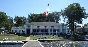
The Lake Hopatcong Yacht Club is a special place in Mount Arlington. It was started in 1905 and is a private club. It sits on a small piece of land called a peninsula on Bertrand Island. The club's main building, finished in 1910, has a unique Adirondack style. This building is so important that it was added to both the National and New Jersey lists of historic places in 1999.
Population and People
| Historical population | |||
|---|---|---|---|
| Census | Pop. | %± | |
| 1900 | 275 | — | |
| 1910 | 277 | 0.7% | |
| 1920 | 213 | −23.1% | |
| 1930 | 306 | 43.7% | |
| 1940 | 456 | 49.0% | |
| 1950 | 639 | 40.1% | |
| 1960 | 1,246 | 95.0% | |
| 1970 | 3,590 | 188.1% | |
| 1980 | 4,251 | 18.4% | |
| 1990 | 3,630 | −14.6% | |
| 2000 | 4,663 | 28.5% | |
| 2010 | 5,050 | 8.3% | |
| 2020 | 5,909 | 17.0% | |
| 2023 (est.) | 5,931 | 17.4% | |
| Population sources:1900–1920 1900–1910 1910–1930 1940–2000 2000 2010 2020 |
|||
In 2010, Mount Arlington had 5,050 people living there. By 2020, the population grew to 5,909. This shows that more people are choosing to live in Mount Arlington. The average age of people in Mount Arlington in 2010 was about 45.8 years old.
Schools in Mount Arlington
The Mount Arlington School District provides public education for students from kindergarten up to eighth grade. The district has two schools.
Elementary and Middle Schools
- Edith M. Decker School: This school teaches students from Kindergarten through second grade.
- Mount Arlington Public School: This school is for students in grades 3 through 8.
Both schools are located near the eastern side of Lake Hopatcong.
High School Education
After eighth grade, students from Mount Arlington attend Roxbury High School. This high school is located in Roxbury Township. It serves students from ninth through twelfth grades.
Getting Around Mount Arlington
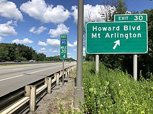
Mount Arlington has a good network of roads and public transportation options.
Major Roads
Interstate 80 is the main highway that goes through Mount Arlington. It runs for almost 1.4 miles in the borough. There is one exit, Exit 30, located within Mount Arlington, making it easy to get on and off the highway.
Public Transport
- Train Service: NJ Transit offers train service from the Mount Arlington station. You can take trains on the Morris & Essex Lines and the Montclair-Boonton Line. These trains go to places like Newark Broad Street Station, Hoboken Terminal, and even New York Penn Station in Midtown Manhattan.
- Bus Service: Lakeland Bus Lines also provides bus service. Their buses travel along Interstate 80 between Newton and the Port Authority Bus Terminal in Midtown Manhattan.
Famous People from Mount Arlington
Many interesting people have lived in or are connected to Mount Arlington:
- Larry Arico (born 1969), a former college football coach.
- Lotta Crabtree (1847–1924), a well-known actress.
- Cortlandt V.R. Schuyler (1900–1993), a four-star general in the United States Army.
- Harry L. Sears (1920–2002), a politician who served in the New Jersey Legislature.
Images for kids
See also
 In Spanish: Mount Arlington para niños
 | Percy Lavon Julian |
 | Katherine Johnson |
 | George Washington Carver |
 | Annie Easley |


