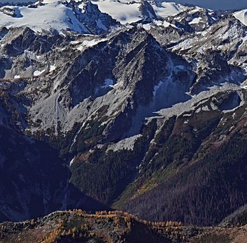
Mount Berge facts for kids
Quick facts for kids Mount Berge |
|
|---|---|

Mt. Berge, east aspect, from Mount Maude
|
|
| Highest point | |
| Elevation | 7,960 ft (2,430 m) |
| Prominence | 1,000 ft (300 m) |
| Isolation | 1.2 mi (1.9 km) |
| Parent peak | Cirque Mountain (7,966 ft) |
| Geography | |
| Location | Glacier Peak Wilderness Chelan County, Washington, U.S. |
| Parent range | North Cascades Cascade Range |
| Topo map | USGS Clark Mountain |
| Geology | |
| Age of rock | Cretaceous |
| Type of rock | Granodiorite |
| Climbing | |
| Easiest route | class 3 scrambling |
Mount Berge is a tall mountain in Washington state, standing about 7,960 feet (2,426 meters) high. It has two main peaks and is made of a type of rock called granite. You can find it in the beautiful Glacier Peak Wilderness area, which is part of the North Cascades mountain range.
This mountain is located in Chelan County, right on the crest of the Cascade Range. It's managed by the Okanogan-Wenatchee National Forest. Mount Berge is part of the Chiwawa Ridge, which also includes other notable peaks like Fortress Mountain and Chiwawa Mountain.
Water flowing from Mount Berge goes into the Napeequa River or into streams that feed the Chiwawa River. The mountain was named to remember Richard Waldo Berge, a young climber who sadly passed away during a climb on Baring Mountain in 1952. Richard Berge was known for making several first ascents (the first time someone successfully climbs a mountain) in the Cascade Mountains.
How Mountains Form
The North Cascades mountains are known for their rugged shapes, with sharp peaks, long ridges, and deep valleys carved by glaciers. The amazing look of these mountains was created by geological events that happened millions of years ago. These events caused huge changes in the land's height and led to different climates across the Cascade Range.
The story of the Cascade Mountains began millions of years ago. The North American Plate (a giant piece of Earth's crust) slowly moved over the Pacific Plate. This movement caused volcanoes to erupt over and over again. Also, small pieces of Earth's crust, called terranes, came together to form the North Cascades about 50 million years ago.
During the Pleistocene period, which started over two million years ago, huge sheets of ice called glaciers moved across the land. They carved and shaped the landscape, creating the deep valleys we see today. The glaciers were biggest about 18,000 years ago. Most valleys were free of ice by 12,000 years ago. The main forces that created the tall peaks and deep valleys in the North Cascades were the lifting of the land (called orogeny) and cracks in the Earth's crust (called faulting), along with the action of glaciers.
Volcanic activity started about 90 million years ago. Then, about 35 million years ago, a lot of volcanic eruptions began. Glacier Peak, a large volcano, started forming about 7.8 miles (12.6 kilometers) west of Mount Berge. Because Glacier Peak is so close, you can often find volcanic ash in the area around Mount Berge.
Weather in the Mountains
Most of the weather in this area comes from the Pacific Ocean. These weather systems travel northeast towards the Cascade Range. As they reach the North Cascades, the mountains force the air upward. This process, called Orographic lift, makes the air cool down and drop its moisture. This means a lot of rain or snow falls on the western side of the North Cascades.
During winter, the weather is usually cloudy, and there's a lot of snowfall. However, in the summer, high-pressure systems over the Pacific Ocean become stronger. This often leads to clear skies and sunny weather. Because the ocean influences the weather, the snow tends to be wet and heavy. This can sometimes lead to a high risk of avalanches.
 | Frances Mary Albrier |
 | Whitney Young |
 | Muhammad Ali |


