
Musbury Valley facts for kids
Quick facts for kids Musbury Valley, Helmshore
|
|
|---|---|
 Trees by Musbury Brook |
|

Musbury Valley, Helmshore
|
|
| OS grid reference | SD772212 |
| District | |
| Shire county | |
| Region | |
| Country | England |
| Sovereign state | United Kingdom |
| Post town | ROSSENDALE |
| Postcode district | BB4 |
| Dialling code | 01706 |
| Police | Lancashire |
| Fire | Lancashire |
| Ambulance | North West |
| EU Parliament | North West England |
| UK Parliament |
|
The Musbury Valley is a small valley located in the Helmshore area of Rossendale Valley, Lancashire. A stream called Musbury Brook flows right through it. The valley's south side is overlooked by a hill called Musbury Tor.
Hundreds of years ago, in the 1300s, this valley was part of a big hunting park owned by the Earl of Lincoln. Today, most of the Musbury Valley is used for sheep grazing. To the south, you'll find Musbury Tor and Alden Valley. To the north-west are Musbury Heights and the Grane Valley. The stream starts as Long Grain Water on Musden Head Moor. It becomes Musbury Brook after joining with Short Grain Water. It then flows north-west to meet the River Ogden, which is a smaller river flowing into the River Irwell.
Contents
Musbury Park: A Medieval Hunting Ground
In 1305, a huge ditch and earth bank were built around a large area. This area included most of the west side of what is now Helmshore. Oak stakes were used to create a strong fence outside the ditch. This fence stretched from Grane Valley in the north to Alden Valley in the south.
This big enclosure was made to keep fallow deer inside. These deer were for Hugh de Lacy's estate, providing venison (deer meat) for his meals. Musbury Valley was right in the middle of this deer park. The park was very large, covering about 1,713 acres. It was known as Musbury Park.
Deer parks were very popular in the early 1300s. However, by the mid-1300s, many parks started to decline. The arrival of the Black Death (a terrible plague) sped up this decline. By 1480, no park-keepers were hired to look after the deer. A survey in 1507 reported that the park was closed down. The old park area was then divided into eight different land sections. Four of these sections included parts of Musbury Valley.
The process of dividing up the old park continued through the 1500s and 1600s. By the 1840s, a detailed map showed more than 20 farms in the valley.
Farming Life in the Valley
After the hunting park closed, most people in the valley earned a living by combining farming with making textiles. They raised animals like cattle, sheep, pigs, and chickens. They also grew some crops on their land. Records from the 1600s and early 1700s show that corn, oats, and barley were grown here.
There's also a fun story about illegal whisky distilling in Musbury! In 1881, a man known as 'Musbury Jim' (James Barlow) was caught with a whisky still at Hare Clough. He had to pay a fine of £10. Several farms near Hare Clough were raided by tax officers in the 1880s. Stories of distilling in Musbury continued throughout the 1800s.
The moorland (open, uncultivated land) also gave farmers "turbary rights." This meant they could take peat (decayed plant matter used as fuel) from the moorland for their fires. Peat sods could also be used to repair banks. However, stone quarrying meant that walls could be built from stone taken from the moorland. These dry stone walls are still a common sight in the area today.
Textile Industry: From Wool to Cotton
From the 1500s to the 1700s, textile production was small. It was done at home and helped farmers earn extra money. Tannery work, which involves making leather, also grew. The name "Tan Pits" is still used for the Helmshore end of the valley.
But in the 1700s, the textile industry grew very quickly. Musbury Brook provided water power for mills. In 1790, the first mill was built at Tan Pits. Soon, more mills followed. The first mills were used for carding wool (preparing it for spinning) or for fulling and finishing woollen cloth.
After 1800, things started to change from wool to cotton. This change began in Alden Valley. Soon, the Turner family started building much larger mills in the Musbury area. By the early 1800s, they were one of the biggest textile companies. They owned several mills in the Musbury area.
William Turner passed away in 1852. Around this time, the Porritt family was developing Sunnybank mills. During the cotton famine (a time when cotton was scarce), things were difficult for the Musbury mills. However, new owners, the Ashworths, expanded Turner's Middle Mill. Soon, they employed 200 workers in their mills.
After 1850, the older mills in Musbury started to close. Production moved from the smaller, outlying areas to the new village growing in Helmshore. This trend continued. In 1883, the local government unit known as Musbury was removed. The area then became known as Helmshore.
During the 1900s, the textile industry faced a big decline. Most of the mills closed down. After World War II, the remaining companies worked together. They opened a research centre. In 1956, this centre moved into a new building. However, it finally closed in 1981.
The Water Board's Plans
The farms at the top of the valley were abandoned quite early on. The Porritt family, who had hunting rights in the surrounding moorland, built kennels (dog houses) in the garden of Longfield House. This house had been built around 1800.
But in 1929, the Porritts left Helmshore. In 1934, they sold their land – 806 acres – in Musbury Valley to the Irwell Valley Water Board. The Water Board developed a plan to flood the valley and create a reservoir (a large lake for storing water). This plan was worked on throughout the 1950s.
During this time, much of the valley was left empty and fell into disrepair. However, people could still visit it. It became a popular spot for picnics and walking. In the end, the reservoir was never built.
Heavy rain in July 1964 caused a flood. This flood destroyed much of the footpath next to the brook at the bottom of the valley.
Musbury Heights: An Old Quarry
On the north-west side of the valley is Musbury Heights. Between 1850 and 1931, this area was a very large quarry. A quarry is a place where stone is dug out of the ground. Here, they dug out a type of stone called Lower Haslingden Flag.
The quarry is now disused, meaning it's no longer active. However, it has been tidied up by a project called "Rossendale Groundwork Valley of Stone." You can still see the ruins of several buildings and a rebuilt chimney from a "Scrubbing Mill." There are also many spoil heaps (piles of waste rock) and old workings. This includes a large tramway system, which had an incline (a sloping track). The quarry mainly produced setts (cobblestones for roads), kerbstones (for pavements), and flagstones (flat stones for paving).
Gallery
-
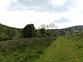
Looking into the valley from the path following the brook.
-
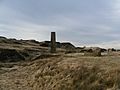
A view of the chimney, ruined buildings and spoil heaps of Musbury heights.


