
Alden Valley facts for kids
Quick facts for kids Alden Valley, Helmshore
|
|
|---|---|
 Alden from Stake Lane |
|

Alden Valley, Helmshore
|
|
| OS grid reference | SD772197 |
| District | |
| Shire county | |
| Region | |
| Country | England |
| Sovereign state | United Kingdom |
| Post town | ROSSENDALE |
| Postcode district | BB4 |
| Dialling code | 01706 |
| Police | Lancashire |
| Fire | Lancashire |
| Ambulance | North West |
| EU Parliament | North West England |
| UK Parliament |
|
The Alden Valley is a beautiful small valley located in Lancashire, England. It sits on the eastern edge of the West Pennine Moors, just west of Helmshore.
Long ago, in the 1300s, this valley was part of a large hunting park owned by a powerful Earl. Later, around 1840, it became home to about twenty farms. These farms mainly raised cattle, but most people also worked with textiles. This textile work quickly grew during the Industrial Revolution, leading to the building of large mills. Today, these mills are gone. The valley is now mostly used for sheep grazing, with a few working farms and smaller landholdings.
To the north and north-west, you'll find Musbury Tor. To the south-west is Scholes Height, and to the west are Musden Head Moor and Burnt Hill. South of the valley are Bull Hill and Holcombe Moor, and to the south-east is Beetle Hill. The Alden Brook starts from several streams that flow from Wet Moss. These streams join together in an area called Alden Ratchers. The Alden Brook is the last stream to join the River Ogden before it meets the River Irwell.
Contents
What Does Alden Mean?
The name Alden might come from old English words. Some people think it means 'elf-valley', combining ælf (elf) and denu (valley). Another idea is that it comes from alor, which is the old English word for an alder tree.
The Story of Ellen Strange
There's a sad story about a young woman named Ellen Strange. She was murdered by her lover on a footpath above Alden Valley, on the way to Edgworth. A pile of stones, called a cairn, marks the spot. In 1978, a special stone carved by artist Don McKinlay was placed there as a memorial. A Victorian song, or ballad, was also written about her story. The memorial is on Beetle Hill, which looks over the valley, south of Alden Farm. You can reach it by following the path to Robin Hood's Well and then continuing onto the moorland.
Alden Valley's Old Deer Park
Around 1304, a nobleman named Henry de Lacy, 3rd Earl of Lincoln, created a huge deer park that included the Alden Valley. We don't know the exact size, but it was probably between 900 and 1100 acres. To keep the deer inside, a massive ditch was dug all around the area. This ditch included both the Alden and Musbury Valleys.

This deer park was a hunting area, but it stopped being used for that purpose over the next few hundred years. However, you can still clearly see parts of the old boundary ditch between Alden Reservoir and Fall Bank. Having a hunting park was a sign of importance back then. There were about 3,200 such parks across England!
The park would have been filled with fallow deer. There was at least one gate in the fence around the park in Alden Valley. In 1323, a park-keeper was hired to look after the deer. By 1480, there were no more park-keepers. Later, in 1507, parts of the park land were rented out.
Great House and Tor Side House
The first Great House was built around the same time the Deer Park was created. A stone from a second Great House, built in 1600, can be seen in a nearby farm building. It has the initials RHAH, likely for Ralph and Alice Haworth, who owned the house then.
Below Great House, surrounded by trees, is Tor Side House. Joseph Porritt built this house around 1868 for himself. He wanted a quiet place away from the smoke of his mills. His son, William John Porritt, later built his own house here, far enough from his mills and the busy areas. The Porritt family bought most of the farms in the valley, becoming the biggest landowners. They also planted many of the trees you see in the lower valley today.
From 1949 to 1982, Tor Side House was used as offices for the Great House Experimental Farm. In 2010, it was even used as a filming location for the BBC drama series Survivors.
Other Farms in the Valley
In the 1600s, people could start buying land outside the old deer park. This led to the creation of new farms. You can still see old ridge and furrow patterns in the ground, which show where crops were grown long ago. Most of these farms were built near natural springs.
For example, Christopher Cronkshaw built Cronkshawfold Farm in 1631. Top o' th' Rake, which is now Alden Farm, was built soon after. In the early 1800s, Spring Bank Farm was built on the sunny, south-facing slopes of the valley. These farms could also use the nearby Holcombe Moor. This meant they could graze animals there. They also had the right to cut peat for fuel and dig stone from their land.
Early Mills in Alden Valley
Many farms built in the 1600s combined farming with making textiles. They might have had a loom or two in one of their rooms. By the late 1700s, the first small mills, powered by water, were built in Alden. Midge Hole Mill was built in 1794, and Sunnybank Mill in 1798.
The first mill built just for cotton was Higher Alden Mill, in 1810. It was near a small bridge below Alden Farm. It was quite small, producing only a little power. In the 1820s, a larger mill with a reservoir was built downstream in what is now Alden Wood. These small mills eventually closed by the mid-1800s. Larger mills and houses grew up in Helmshore, near the main roads and railway. The smaller mills in Alden Valley were no longer practical, and the valley went back to being mainly farmland.
Sunnybank Mill Site
The houses built in the late 1990s above Wood Bank in Helmshore are on the site of the old Sunny Bank Mill. Joseph Porritt built this mill in the late 1800s, on the spot where his smaller, older mills once stood. For a time, it had the longest loom in the world! It was also one of the biggest producers of industrial felt, mainly for making paper.
The stone for Porritt's buildings in St Annes on Sea came from his quarries in Alden Valley. In the 1970s, the mill was sold and later torn down in 1977. Its tall chimney, a famous landmark in Helmshore, was also demolished. Today, you can still see the base of a wall from one of the mill buildings in the nearby woods, and a large cut into the hillside. These are some of the only parts of the mill that remain.
Robin Hood's Well
On Stake Lane, a moorland road, there's a well linked to the legend of Robin Hood. The story says that Robin Hood stopped for a drink here, and his foot left a mark in a stone above the spring. This road was once thought to be a path for pilgrims going to Whalley Abbey. More recently, it's been identified as a "drove road," used to move animals. The well was probably a resting place along this route.
There used to be an annual Robin Hood festival in Bury until 1810. Today, the route is popular with walkers and cyclists. It's also the way to reach the Ellen Strange memorial.

Pilkington's Township
Deep in Alden Valley, on the north side of the brook, you can find the ruins of Alden Old Mill. This was an old bleach works built by Robert 'Rough Robin' Pilkington. He got his nickname because he always said the weather was 'a bit rough'. The area is still known as the Township of Pilkington. You can find the ruins of his farm, Spring Bank Farm, above the ruined mill. He took over common land and refused to pay his taxes. Because of this, he was denied help during a difficult time in the 1820s.
Alden Valley During WWII
Local historian Chris Aspin remembers that during World War II, four Home Guardsmen would climb to the top of Musbury Tor every evening to watch for invaders. They had a small hut for shelter, but no phone. If an invasion happened, one of them would have had to run down to their headquarters.
He also said that American soldiers (GIs) practiced military exercises in Alden Valley using real ammunition before D-Day. The West Pennine Way guide also mentions that American GIs set up camp on Musbury Tor to practice parachute drops and field exercises with live ammunition.
Protecting the Moorland
From December 2019 to April 2020, important work was done at Alden Ratchers, the high moorland at the top of Alden Valley. This area is a special type of wetland called a blanket bog, which has formed over 6,000 years and has peat up to three metres deep.
Over the last century, much of this bog has been damaged. This was mostly because people tried to drain the land, thinking it would be better for grazing animals. But this drainage caused many environmental problems:
- The land became less suitable for moorland birds to breed.
- It increased the risk of flooding downstream, which has become a bigger problem for Helmshore village.
- The peat could no longer store carbon, which is important for reducing carbon in our atmosphere.
Several groups, including Natural England, have supported this work. Their goals include building permeable dams to slow down floodwater. Stones for this work were brought by helicopter from a quarry a kilometre away. They also dug pools in some areas to reduce the free flow of water across the moorland. Special moss called Sphagnum moss has been planted in the newly wetted areas. This will help the top layers of the peat hold water better, instead of letting it flow away quickly.
Gallery
-
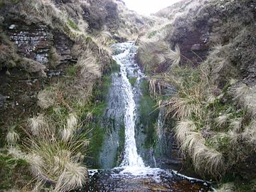
A waterfall in the Alden Ratchers tributary
-
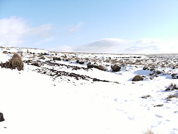
Snowdrift on Wet Moss at the end of the valley between Helmshore and Edgeworth, during February 2009.


See Also
