Nayland facts for kids
Quick facts for kids Nayland |
|
|---|---|
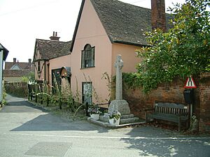
 Alston Court and War Memorial, located in the centre of Nayland village |
|
| Population | 938 (2011) |
| OS grid reference | TL975342 |
| Civil parish |
|
| District |
|
| Shire county | |
| Region | |
| Country | England |
| Sovereign state | United Kingdom |
| Post town | Colchester |
| Postcode district | CO6 |
| Dialling code | 01206 |
| Police | Suffolk |
| Fire | Suffolk |
| Ambulance | East of England |
| EU Parliament | East of England |
| UK Parliament |
|
Nayland is a village in Suffolk, England. It is located in the Stour Valley, right on the border between Suffolk and Essex. In 2011, about 938 people lived in the village.
Nayland used to be its own civil parish, which is a local area with its own council. Now, it is part of a larger parish called Nayland-with-Wissington.
Contents
A Look Back: Nayland's History
Nayland and a nearby small area called Wissington (often called 'Wiston') were once two separate places. On March 25, 1884, they joined together to form one civil parish called Nayland-with-Wissington. Even though they share a civil parish, their church areas (called ecclesiastical parishes) are still separate. In 1881, the civil parish had a population of 901 people.
Nayland and Wiston are on the north side of the River Stour. This river acts as the border between Essex and Suffolk.
How Nayland Grew
The name Nayland means "an island." The village grew on higher ground surrounded by the lower river flood plain. This made it a good spot for people to cross the river safely. It also became an early center for a manor, which might have had a wooden castle.
These advantages helped Nayland become a market by 1227. By the late Middle Ages, it was a successful small town. The people who owned the manor moved away, and the town was then run by its cloth merchants. Many of these merchants were very rich for their time. They were only less wealthy than the merchants in Lavenham and Long Melford.
These wealthy merchants built beautiful Tudor houses and a grand church. The town's success continued into the early 1600s.
Changes in Trade and Time
After the early 1600s, the cloth trade started to decline in Nayland. Other businesses like leather and soap making grew, but Nayland mostly became a trading center for the surrounding countryside. During the 1700s and 1800s, the village remained relatively quiet.
The river was made easier to travel on, but this did not bring a big increase in trade. A good thing about this quiet period was that people did not tear down the beautiful old houses to build new ones. Because of this, Nayland still has its lovely Tudor and Stuart streets today.
Wiston's Story
Wiston, also known as Wissington, was originally a separate farming area. It was part of Nayland's manor in 1066. But by 1087, it was given to a different Norman family who lived in Essex. From then on, Nayland and Wiston had different histories.
Wiston was managed from across the river, and its connections were more with Little Horkesley in Essex than with Nayland. The Lords of the Manor built the small Norman church in Wiston, which is still a separate church today. Early records show that Wiston was mainly a farming area until the late 1800s.
Joining Together: Nayland with Wissington
In 1883, the new West Suffolk county council decided to join the two separate civil parishes. Nayland and Wissington became one parish, even though Wiston residents were not happy about it. The needs of the two parts, one more like a town and one more agricultural, still make them a bit different. The Nayland with Wissington Parish Council was created in 1894.
The Sanatorium and Hospital
In 1896, Dr. Jane Walker bought two farms and started the East Anglian Sanatorium. This hospital opened in 1901 to treat patients with tuberculosis (TB). Famous people like the writer George Gissing and the artist Emily Carr were patients there.
The Sanatorium closed in the 1950s after TB was largely cured. The building then became a hospital for people with learning disabilities. These hospitals provided many jobs and were important to Wiston. In 1991, the hospital closed. The original Sanatorium building, designed in the 'arts and crafts' style, became a protected building and was turned into eight houses.
Wiston still has seven working farms today. Most residents now work from home or in other places, as farming needs fewer workers due to machines.
Nayland Today
The parish of Nayland-with-Wissington is in the Babergh area. It is also part of the South Suffolk area for Parliament. The village has a population of 938 people.
Nayland is located in the beautiful Dedham Vale, which is an area of Outstanding Natural Beauty. This area is along the River Stour, which forms the border between Suffolk and Essex.
Village Features
In 1969, a new road, the A134 road, was built around Nayland. This road connects Colchester, which is six miles south, to Sudbury, which is nine miles north.
Nayland has several buildings from the 1400s. One of these is Alston Court, which also has a part that dates back to the 1200s.
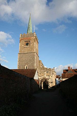
The village church, St James, has a famous painting. It is called Christ Blessing the Bread and Wine and was painted by John Constable.
Littlegarth School has been located at Horkesley Park, Nayland, since 1994.
There is also a small airfield in Nayland. It has grass runways for small planes. However, there are rules about how many planes can take off and land, and what types of planes can use it.
See also
 In Spanish: Nayland para niños
 | Leon Lynch |
 | Milton P. Webster |
 | Ferdinand Smith |


