
New Barbadoes Neck facts for kids


New Barbadoes Neck is a special piece of land in northeastern New Jersey, USA. It's a peninsula, which means it's land mostly surrounded by water. This neck of land sits between two rivers, the Hackensack and the Passaic River.
You can find New Barbadoes Neck in parts of Hudson County and Bergen County. It starts in the south at a place called Kearny Point, near Newark Bay. The land here has a ridge (a long, narrow hill) on its western side. On the eastern side, you'll find flat, marshy areas known as the New Jersey Meadowlands. These are flood plains of the Hackensack River.
Contents
- Who Lived Here First? Native Americans and Dutch Settlers
- How Did the British Get the Land?
- New Barbadoes Township: A New Local Government
- The Schuyler Copper Mine and America's First Steam Engine
- New Barbadoes Neck During the American Revolution
- How the Area Changed in the 1800s
- The Meadowlands: Development and Protection
- Images for kids
Who Lived Here First? Native Americans and Dutch Settlers
Long ago, this area was home to the Lenape people. They were a group of Native Americans. The Lenape called this land Meghgectecock. This name meant "where May-apples grow." May-apples are plants that grow in moist woodlands and have tasty yellow berries. The specific Lenape group living here was called the Hackensack.
Later, in the mid-1600s, people from the Netherlands arrived. This was during the time of New Netherland. They called the area Achter Col. This Dutch name means "rear mountain pass" or "behind the ridge." It was important because it gave them a way to reach the lands further inland. These lands were rich with animals for fur trapping.
How Did the British Get the Land?
In 1664, the Dutch gave up their control of Fort Amsterdam. This meant the area became part of the Province of New Jersey under British rule.
On July 4, 1668, a man named William Sandford received a large piece of land. It was about 15,308 acres (62 square kilometers). In the official paper for this land, it was called "New Barbados." Sandford also paid Chief Tantaqua of the Hackensack Indians 20 English Pounds Sterling. This was to make sure all their rights to the land were settled.
A year later, on June 10, 1669, John Berry got another large piece of land. It was 10,000 acres (40 square kilometers) just north of Sandford's land.
In 1671, Sandford's land was split between him and his uncle, Nathaniel Kingsland. Sandford kept the southern part, and Kingsland got the northern two-thirds. Nathaniel's nephew, Isaac Kingsland, started settling the Kingsland part around 1683. From 1668 to 1687, New Barbadoes was part of Newark Township.
Today, you can still find names that remember these early settlers. Sandford Avenue in Harrison and Kearny is named after the Sandford family. The Kingsland Station, Kingsland Avenue in Lyndhurst, and Kingsland Manor are named after the Kingsland family. Berrys Creek and the historic Yereance-Berry House remember John Berry.
New Barbadoes Township: A New Local Government
In 1710, a new local government area was created. It was called New Barbadoes Township. This township covered all of the neck of land. It also included areas to the north and west, reaching the Saddle River. At this time, the land was moved from Essex County and became part of an expanded Bergen County.
The Schuyler Copper Mine and America's First Steam Engine
In 1710, the Kingsland family sold a piece of land to Captain Arent Schuyler. He was a former trader and a member of the important Schuyler family. This new land included what is now Kearny, North Arlington, and Lyndhurst.
After Schuyler bought his new home, people found copper in the ground! This led to the opening of the Schuyler Copper Mine. However, the mine soon filled with water. To solve this problem, the very first steam engine in America was built and used. It helped pump the water out of the deep mine shaft. The engineer Josiah Hornblower secretly built this amazing engine.
Sadly, the engine and mines were destroyed by a fire in 1768. They stayed closed for many years. Today, Schuyler Avenue runs along the eastern edge of the ridge. It is named in honor of this early settlement and the Schuyler family.
New Barbadoes Neck During the American Revolution
During the American Revolutionary War, Lord Howe of England took control of New York Harbor. The Schuyler Mansion was close by, so many British officers visited it. They traveled on a road now known as the Belleville Turnpike. This road was first built in 1759 using cedar logs from nearby swamps.
In September 1777, Henry Clinton was the head of the British forces in America. He chose Schuyler Mansion as his headquarters for some important military actions. These included raids along the Second River.
How the Area Changed in the 1800s
In the 1800s, New Barbadoes Neck came under the control of different townships. In 1840, part of it became part of the newly created Hudson County.
The Meadowlands: Development and Protection
A large part of this peninsula has been part of the New Jersey Meadowlands District since 1968. This area is known for its unique environment.
Images for kids
-
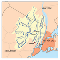
New Barbadoes Neck is between the Hackensack and Passaic Rivers
-
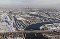
The southern end of New Barbadoes Neck is now known as South Kearny, with the tip known as Kearny Point
