North Waziristan District facts for kids
Quick facts for kids
North Waziristan District
ضلع شمالی وزیرستان
شمالي وزیرستان ولسوالۍ |
|
|---|---|
|
District of Khyber Pakhtunkhwa
|
|
|
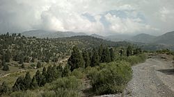
Top: Shawal Valley
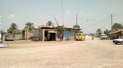
Bottom: street in Mir Ali |
|

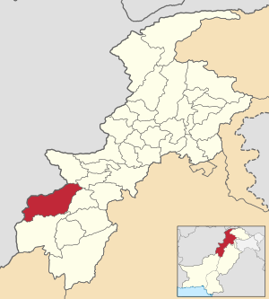
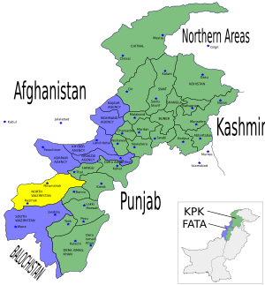
Map of North Waziristan District
|
|
| Country | |
| Province | |
| Division | Bannu |
| Established | 1910 (as an agency of Federally Administered Tribal Areas) |
| Headquarters | Miranshah |
| Number of Tehsils | 9 |
| Government | |
| • Type | District Administration |
| Area | |
| • Total | 4,707 km2 (1,817 sq mi) |
| Population
(2017)
|
|
| • Total | 540,546 |
| • Density | 114.839/km2 (297.43/sq mi) |
| Time zone | UTC+5 (PST) |
| Main language | Pashto |
North Waziristan District (Pashto: شمالي وزیرستان ولسوالۍ, Urdu: ضلع شمالی وزیرستان) is a district in the Khyber Pakhtunkhwa province of Pakistan. It's the northern part of Waziristan, a mountainous area in northwest Pakistan. This region shares a border with Afghanistan and covers about 4,707 square kilometers (1,817 square miles). The main city and capital of North Waziristan is Miranshah.
Contents
About North Waziristan
North Waziristan is located west and southwest of Khyber Pakhtunkhwa. It lies between the Kurram River (Tochi) in the north and the Gomal River in the south. The city of Bannu is just to its east. On the Afghan side of the border, the largest town is Khost.
North Waziristan is split into three main areas: Mirali, Miran Shah, and Razmak. These three areas are then divided into nine smaller parts called tehsils. These tehsils are: Datta Khel Tehsil, Dossali Tehsil, Gharyum Tehsil, Ghulam Khan Tehsil, Mir Ali Tehsil, Miran Shah Tehsil, Razmak Tehsil, Shewa Tehsil, and Spinwam Tehsil.
A Look Back in Time
The British first came to Waziristan in 1894. After some military actions in 1894–95, Waziristan was divided into two "agencies": North Waziristan and South Waziristan. An "agency" was a special administrative area. Even though they were separated, both parts are home to subgroups of the Wazir tribe, which the region is named after. People here are known for being strong warriors and very welcoming.
In 1910, North Waziristan became a full "agency" with its main office in Miramshah. The main tribes living here are the Wazir and Dawar tribes. The area borders Afghanistan, Kurram Agency, and Hangu District to the north. To the east, it borders tribal areas next to the Bannu and Karak Districts. To the south and west, it borders South Waziristan Agency and Afghanistan.
Modern Times
In 2014, about 98,640 people had to leave their homes in North Waziristan. This happened because of a military operation called Operation Zarb-e-Azb, carried out by the Pakistan Armed Forces near the border with Afghanistan. These people became known as "internally displaced persons" because they moved within their own country.
In 2018, North Waziristan officially became a district of the Khyber Pakhtunkhwa Province in Pakistan. This happened after the entire FATA (Federally Administered Tribal Areas) region was merged into Khyber Pakhtunkhwa, with approval from the Parliament.
Geography of North Waziristan

North Waziristan is a land of tall, challenging hills with deep, rough valleys. The mountains here are separate from the larger mountain ranges like Koh-e-Sufaid in the north and Sulaiman in the south. These mountains and hills act like a natural wall between Pakistan and Afghanistan. The hills in Waziristan are usually between 1,500 and 2,500 meters (4,900–8,200 feet) above sea level.
The Tochi River flows through the area, forming the Tochi Pass. This pass has been an important route for armies, people, and cultures moving between Ghazni, Afghanistan, and Bannu, Pakistan. The Tochi River has created a large and important valley that is fertile and good for farming. It is about 100 kilometers (62 miles) long and opens into the Indus Valley near Bannu. Other smaller rivers in the northern part of the area include Ketu and Kurram.
Rivers and Streams
North Waziristan has five main rivers: Tochi, Kaitu, Kurram, Khaisor, and Shaktue. There are also many notable streams like Kishi Aigad, Chashma Aigad, Saidgi Algad, Kanungo Aigad, Sagga Aigad, Tauda China Algad, Damoma Algad, Tarkhobi Algad, and Suedar Aigad.
Administration
North Waziristan District is currently divided into nine tehsils, which are like sub-districts:
- Datta Khel Tehsil
- Dossali Tehsil
- Gharyum Tehsil
- Ghulam Khan Tehsil
- Mir Ali Tehsil
- Miran Shah Tehsil
- Razmak Tehsil
- Shewa Tehsil
- Spinwam Tehsil
Local Government
The district is managed by a Political Agent who handles civil, criminal, and revenue cases. This is done according to local laws and customs. The Political Agent is helped by Assistant Political Agents who deal with smaller cases and help keep law and order. There are also Political Tehsildars and Political Naib-Tehsildars who are in charge of the tehsils. They help control the tribes and maintain peace in their areas.
The "Maliki system" is also important here. Maliks are respected elders who act as a link between the government and the tribes. This system helps in solving local issues and maintaining peace.
Climate
The weather in North Waziristan is cold in winter and warm in summer. Summer lasts from May to September, with June being the hottest month. In June, temperatures average between 18 and 31 degrees Celsius (64–88 degrees Fahrenheit). Winter starts in October and lasts until April. December, January, and February are the coldest months, with average temperatures between -2 and 10 degrees Celsius (28–50 degrees Fahrenheit). The area generally receives low rainfall, except for the Razmak area, which gets a bit more rain.
Archeological Finds
In 1966, a researcher named Ahmad Hasan Dani found evidence of ancient Buddhist sites in the area. He noted that coins from old rulers had been found before. He also mentioned that a Buddhist Stupa (a type of religious building) site was found near Spinwam. This suggests that the region has a long and interesting history, even if not much is known about its very early days.
People of North Waziristan
| Historical population | ||
|---|---|---|
| Year | Pop. | ±% p.a. |
| 1951 | 128,235 | — |
| 1961 | 159,470 | +2.20% |
| 1972 | 250,663 | +4.20% |
| 1981 | 238,910 | −0.53% |
| 1998 | 361,246 | +2.46% |
| 2017 | 540,546 | +2.14% |
| Sources: | ||
According to the 2017 census, North Waziristan had a population of 540,546 people living in 58,880 homes. For every 1,000 males, there were 946 females. About 36.61% of the people could read and write. This was higher for males (59.99%) than for females (12.49%). A small number of people (0.81%) lived in urban areas. About 36.90% of the population was under 10 years old.
In 2017, most people (97.57%) in North Waziristan spoke Pashto as their first language. A smaller number (1.08%) spoke Punjabi.
Ethnic Groups and Tribes
The main tribes in North Waziristan are the Utmanzai, Wazirs, and Dawars. There are also smaller tribes like the Gurbaz, Kharsins, Saidgis, Malakshis, Mahsuds, Banuchi, and Bangashs. Most of these tribes are Pakhtuns.
The Wazirs mostly live in the hilly areas. They are divided into three main groups: Ibrahim Khel, Wali Khel, and Mohmit Khel. These groups are further divided into smaller sections.
The Dawars live in the fertile Tochi valley, mostly on the left side of the Tochi River. They are divided into two main groups: Tor Gund and Spin Gund. Dawars tend to be more educated than Wazirs because many schools are located in the Dawar areas.
Dress and Ornaments
The men in the tribes usually wear a shirt, trousers, a waistcoat, a sheet of cloth, a turban, and Chappals (sandals). Wazir women wear a sleeved blouse or petticoat, a long heavy shirt called Staar Khat with trousers, and cover their heads and bodies with a sheet of cloth. Married women wear colorful trousers, while unmarried women wear plain ones. For celebrations, Wazir women wear very colorful and decorated blouses and multi-colored dresses. They also wear silver and gold pieces on their foreheads and near their ears.
The clothing of the Dawars is similar to the Wazirs, but there are some small differences due to local traditions and the climate. Dawars also wear many types of clothes commonly seen across Pakistan.
Food
The main food for the tribesmen is bread made from wheat or maize. Milk is also a common part of their diet, used in different forms. Roasted meat, called larmin, is a favorite dish. People in Waziristan also enjoy a fried goat dish called pulawo, especially in the hilly areas.
Homes
The Dawars live in houses that are built close together in a compact area. Large Wazir families often live in one big house called a ket or kot, or in houses next to each other. A kot is a walled area made of mud or mud and stones, about three to five meters (10–16 feet) high. Many kots look like small forts, with a tower in the middle. This tower is used for defense if there is fighting.
Every part of a village has a Masjid (mosque) and a common sitting place. Some homes also have a private guest house called a hujra. Wazir people mostly live near mountains, and their way of life is generally different from the Dawar tribes, who live near rivers and on plains.
Economy
Because the land is rugged and many people lack education, many inhabitants feel they rely on government services. Many also travel abroad to find work. Local people have also put money into transportation businesses. Wazir tribes often run businesses, while Dawar tribes are more likely to work in government jobs, especially in education and civil services.
Mining
Several minerals have been found in the area:
- Copper, found near Boya and Manzarkhel Spinkamar.
- Manganese, found with cherts.
- Chromite, found with serpentinites. There are two chromite mining sites: at Syed Abad and Saidgi.
- Gold and diamond mines in Muhammad Khel.
- Ordinary stones are also mined from hills for building construction.
Currently, chromite and copper mining are happening in Razmak Malakan village.
Notable People
- Arsala Khan, a Pakistani politician
- Mohammed Wasim, a Pakistani cricketer
- Mohsin Dawar, a Pakistani politician
Places to Visit
Miran Shah is the main town of North Waziristan. It is connected to Bannu and other important places by paved roads. This town has government offices and is a market center for the local people.
Razmak and Shawaal Valleys are popular summer spots for people from Waziristan. They are also beautiful places for tourists, with thousands visiting each year.
Razmak Cadet College is a very famous and historic school in the country. Students from all over Pakistan come here to study.
See also
 In Spanish: Waziristán del Norte para niños
 | Charles R. Drew |
 | Benjamin Banneker |
 | Jane C. Wright |
 | Roger Arliner Young |


