South Waziristan District facts for kids
Quick facts for kids
South Waziristan District
ضلع جنوبی وزیرستان
سويلي وزیرستان ولسوالۍ |
|
|---|---|
|
District of Khyber Pakhtunkhwa
|
|

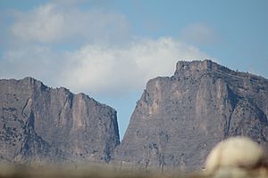
Skanrr Gharra mountain from Kot Nawaz
|
|

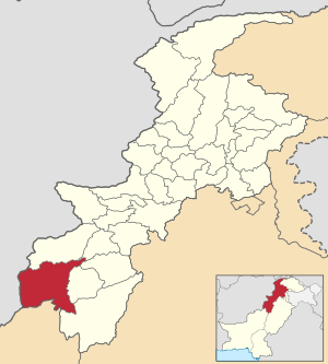
Map of South Waziristan District
|
|
| Country | |
| Province | |
| Division | Dera Ismail Khan |
| Established | 1893 (as an agency of Federally Administered Tribal Areas) |
| Headquarters | Wanna |
| Number of Tehsils | 8 |
| Government | |
| • Type | District Administration |
| Area | |
| • Total | 6,620 km2 (2,560 sq mi) |
| Population
(2017)
|
|
| • Total | 675,215 |
| • Density | 102.00/km2 (264.17/sq mi) |
| Time zone | UTC+5 (PST) |
| Main language(s) | Waziri Pashto Ormari |
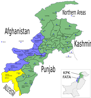
South Waziristan District (Pashto: سويلي وزیرستان ولسوالۍ, Urdu: ضلع جنوبی وزیرستان) was a district in Dera Ismail Khan Division of Khyber Pakhtunkhwa, Pakistan. It was located in the southern part of Waziristan, a mountainous area in northwest Pakistan. The region covers about 6,620 square kilometers (2,556 square miles). Waziristan is found west and southwest of Peshawar, between the Tochi River in the north and the Gomal River in the south.
From 1893, Waziristan was an independent tribal territory. It remained outside the control of both the British Empire and Afghanistan. The British often faced challenges from the local tribes. This led to many military trips between 1860 and 1945. British soldiers even called this region "Hell's Door Knocker" because of the tough local fighters and difficult land.
The main city of South Waziristan is Wanna. South Waziristan was divided into three main areas: Ladha, Sarwakai, and Wanna. These three areas were then split into eight smaller parts called Tehsils. These Tehsils are Ladha, Makin, Sararogha, Sarwakai, Tiarza, Wanna, Barmal, and Toi Khula.
Waziristan was split into two "agencies": North Waziristan and South Waziristan. Even though they are both part of the Waziri tribe and speak a similar language, they have different features. The Waziri people are known for being brave warriors. They traditionally settle disagreements through tribal meetings called jirgas. Waziristan is a very traditional area where families are very important.
In 2018, South Waziristan became a district of Khyber Pakhtunkhwa, Pakistan. This happened when the Federally Administered Tribal Areas (FATA) joined Khyber Pakhtunkhwa. The district shares borders with North Waziristan to the north and Afghanistan to the west.
On April 13, 2022, South Waziristan was divided into two new districts: Upper South Waziristan District and Lower South Waziristan District. Upper South Waziristan includes Ladha, Makin, Tiarza, Sarokai, and Shawal tehsils, with Spinkai Rakhzai as its main town. Lower South Waziristan includes Wana, Shakai, Loi Khwla, and Birmil tehsils, with Wana as its main town.
Contents
History of South Waziristan
The South Waziristan region has a very long history. It was once part of the ancient Indus Valley civilization. Around 500 B.C., it became part of the Persian Achaemenid Empire. Later, Alexander the Great and his Macedonian army came through the area around 330 B.C. After them, the Greco-Bactrians formed an independent Indo-Greek Kingdom.
The region then came under the rule of the Mauryan Empire. Over the centuries, different groups like the Saka, Indo-Parthians, Kushan, and Sassanian Persians ruled the area. In the seventh century, the Arab Rashidun Caliphate brought Islam to the region. Islam continued to spread under later dynasties like the Saffarid dynasty.
In the following centuries, the area was ruled by the Ghaznavid, Ghorid, and Babar empires. Local Pashtoon tribes living near the Hindu-Kush mountains often fought against the expanding British Indian forces. After the 1893 Durand Line agreement, the region remained under British Indian Empire rule until Pakistan became an independent country.
Before 1895, British officials from Dera Ismail Khan and Bannu managed the political affairs in Waziristan. The British gained control of these areas in November 1893. This happened after the Amir of Afghanistan signed a treaty giving up his claims to these lands. After some conflicts, a Political Agent was permanently assigned to South Waziristan in Wanna. Another agent was assigned to North Waziristan. In 1900, a local militia was formed to keep peace. However, there were disturbances in 1904, and some officials were sadly killed. Later, a plan to take over the Wanna fort was discovered. In 1925, the Royal Air Force used air power to calm down the Mahsud tribesmen.
Geography and Rivers

South Waziristan is mostly made up of rugged hills and ridges. There are no clear mountain lines. The land slowly rises from the south and east towards the north and west. The highest mountain range is the Preghal, located in the west along the border with Afghanistan. Its highest peak is 3,515 meters (11,532 feet) tall. The main flat areas in the region are Zarmelan, Wanna, Shakki, Zalai, Spin, and Tiarza.
Most rivers and streams flow from west to south, from the Sulaiman Mountains towards the Indus River. The two main rivers in the area are the Gomal and the Tank Zam. Other important smaller rivers include Khaisora, Shaktu, Siplatoi, Toi Khwla, Shuza, Shinkai, and Shahur. The other streams are mountain streams that can become dangerous during heavy rains, which often happen in July and August. The Gomal River starts in Afghanistan. The Tank Zam is formed where the Tauda China and Baddar Toi rivers meet.
Climate and Weather
South Waziristan has hot summers and very cold winters. In winter, temperatures can drop below freezing point in higher areas. Summer begins in May and ends in September. June is usually the hottest month, with average maximum temperatures just above 30 degrees Celsius (86 degrees Fahrenheit).
Winter starts in October and lasts until April. December, January, and February are the coldest months. During this time, the average high temperature is 10 degrees Celsius (50 degrees Fahrenheit), and the average low is -2 degrees Celsius (28 degrees Fahrenheit). The region is outside the main monsoon zone, but higher areas still get a good amount of rain. South Waziristan has a dry climate with little rainfall. The western part, near Afghanistan, gets more rain than the eastern part because of its higher altitude. Most of the region receives about 6 inches (150 mm) of rain each year.
Population and People
In 2017, South Waziristan had a population of 675,215 people. Of these, 355,611 were males and 319,554 were females. The entire population lived in rural areas. The literacy rate, which is the percentage of people who can read and write, was 34.46%. For males, it was 50.43%, while for females, it was 16.59%.
The two main tribes in the area are the Ahmadzai Wazir and the Mahsud. Other important groups include the Ormur (also called Burki or Baraki), Dotani, Sulaimankhel, Ghilji, Khomia, and Taji. Most people in the district speak Pashto, which is the main language.
Local Dress and Food
The people of South Waziristan wear special traditional clothes. Men usually wear a turban, a loose shirt called a smock, Shalwar (baggy trousers), and a Chaddar (a large piece of cloth). The smock is often white or grey and sometimes has embroidery on the chest. Wealthy men and leaders might wear white cotton smocks. Young educated men sometimes wear modern clothes like people in other parts of Pakistan.
Women wear different colored clothes. Married women often wear dark-blue or dark-red smocks made of thick cotton. Both married and unmarried women wear trousers that fit closely below the knee. Married women also wear a very large dress called a "ganr khat." Unmarried women wear simpler shalwar and qamees (shirt). This makes it easy to tell if a woman is married or not. However, clothing styles are slowly changing as people adopt new fashions, especially those who move to cities.
The people of South Waziristan eat simple meals, mainly wheat and maize bread. They also enjoy chai (tea) and rice cooked with mutton. For special events, they might serve Pulao, which is rice with roasted meat. A famous dish of the Mahsud tribe is "Sohbat." The Dotani and Sulaimankhel tribes enjoy "Korrat," which is half-white rice mixed with ghee (clarified butter made from cow milk). They also like roasted goat meat.
Economy and Work
Most people in South Waziristan, especially the Wazirs, Mahsuds, Dotani, and Suleimankhail, work as pastoralists, meaning they raise animals. The Wazirs breed cows and sheep and earn money from sheep-rearing. Some Suleimankhail also raise horses and sheep. Many of them travel to different parts of Punjab in the summers or even to Iran to find work.
A large number of Mahsuds work in the Army or as local security forces. Many Mahsuds have also started businesses in Tank and Dera Ismail Khan, often driving buses and trucks. The region also produces or trades items like charcoal, wool, potatoes, chilghozas (pine nuts), and some local fruit.
Mining in the Region
There is not much mining in South Waziristan. However, Coal mines have been found in the Wazir area of Neeli Kach Tehsil Wanna. Copper can be found in Preghal and Spin Kamar. Chromite, another mineral, is found in the Sarah Khuara area near Dre Nashter.
Interesting Places to Visit
Wanna is the summer headquarters of the region. The historic Gomal Pass is an important place. It is mentioned as the entry point for Shahab-u-Din Ghouri's army when they attacked India in 1192 AD. Ghouri's forces traveled through South Waziristan. Musa Qala fort, or the house of Pir Bagdadi near WANA bazar, is also an important site.
The old check posts built by the British army on tall mountains show their engineering skills. The Red Bridge, known locally as Seer Pall, at Tiarza, is another impressive sign of British construction in the area. The village of Ghowa Khawa is also a significant place.
Wanna is an important area for both industry and farming. Other important places include Khaisur, Osspass, Karama, Ladha, Makin, Sararogha, Azamwarsak, and Angur Ada. Kaniguram is a large settlement in South Waziristan, located about 7,000 feet (2,100 meters) above sea level. The tribesmen there are known for making small arms and knives. These items are famous for their quality and are popular with tourists and visitors.
Administration and Government
The local government of South Waziristan has been in place since 1895. It is led by a Political Agent who handles civil, criminal, and financial cases based on local laws and customs. The region is divided into three main administrative areas: Ladha, Sarwakai, and Wanna. These three areas are further divided into eight Tehsils: Ladha, Makin, Sararogha, Sarwakai, Tiarza, Wanna, Barmal, and Toi Khwla.
The Sarwakai area is managed by an Assistant Political Officer. The Ladha and Wanna areas are managed by Assistant Political Agents. Each Tehsil is led by a Political Naib Tehsildar. The "Malik system," which was started by the British government, is still used. Maliks act as a link between the government and the local tribes. Being a Malik is usually passed down through families, and they receive benefits and support. There is also a "Lungi system," known as Sufaid Resh, which is a slightly lower form of leadership.
Provincial Assembly Members
| Member of Provincial Assembly | Party Affiliation | Constituency | Year |
|---|---|---|---|
| Hafiz Islam Uddin | Jamiat Ulema-e-Islam (F) | PK-113 South Waziristan-I | 2018 |
| Naseer Ullah Khan | Pakistan Tehreek-e-Insaf | PK-114 South Waziristan-II | 2018 |
Efforts for Peace and Development
On June 4, 2007, the National Security Council of Pakistan met to discuss the future of Waziristan. They made important decisions to improve the situation and control local challenges. The meeting was led by President Pervez Musharraf and included leaders from all four provinces. They talked about improving safety and security in the region.
The government decided to take several steps to bring peace and stability to the tribal areas and Khyber-Pakhtunkhwa. These actions included:
- Using unmanned planes for observation.
- Making law enforcement agencies stronger with better equipment.
- Sending more troops to the region.
- Taking quick action against those causing trouble.
- Focusing on specific leaders who were causing problems.
- Monitoring religious schools that might be promoting violence.
- Appointing local coordinators to help.
- Hiring new police officers in Khyber-Pakhtunkhwa.
The Ministry of Interior helped gather information for these efforts. They made lists of people causing trouble and schools to monitor. The government also worked to strengthen law enforcement by giving the Khyber-Pakhtunkhwa Police weapons, bulletproof jackets, and night-vision devices. The Frontier Corps, a paramilitary force, received artillery and Armored Personnel Carriers (APCs). Government agencies also looked into ways to block illegal FM radio channels.
A major military operation was launched by the Pakistani army on October 17, 2009. While progress has been made, efforts continue to ensure lasting peace and development in all parts of the region.
See also
 In Spanish: Waziristán del Sur para niños
- Battle of Wanna
- Dera Ismail Khan Division
- Bannu District
- North Waziristan District
 | Lonnie Johnson |
 | Granville Woods |
 | Lewis Howard Latimer |
 | James West |

