Northumberland County, Virginia facts for kids
Quick facts for kids
Northumberland County
|
||
|---|---|---|

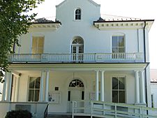
Northumberland County Courthouse in Heathsville
|
||
|
||

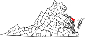
Location within the U.S. state of Virginia
|
||
 Virginia's location within the U.S. |
||
| Country | ||
| State | ||
| Founded | 1648 | |
| Seat | Heathsville | |
| Largest community | Heathsville | |
| Area | ||
| • Total | 286 sq mi (740 km2) | |
| • Land | 191 sq mi (490 km2) | |
| • Water | 94 sq mi (240 km2) 33.0% | |
| Population
(2020)
|
||
| • Total | 11,839 | |
| • Density | 41.40/sq mi (15.983/km2) | |
| Time zone | UTC−5 (Eastern) | |
| • Summer (DST) | UTC−4 (EDT) | |
| Congressional district | 1st | |
Northumberland County is a county in the state of Virginia. In 2020, about 11,839 people lived there. The main town and center of the county government is Heathsville.
Northumberland County is located on a piece of land called the Northern Neck. It is also part of a special area known for making wine, called the Northern Neck George Washington Birthplace AVA.
Contents
History of Northumberland County
When English settlers first arrived, the area was home to Native American tribes. These included the Wicocomico, Chickacoan, and Patawomeck tribes. They spoke a language called Algonquian.
The county was officially created in 1648 by the Virginia General Assembly. This was a time when many people were moving to the area. English settlement here began around 1635.
At first, the area was known as the Indian district Chickacoan. In 1644, it was first called Northumberland. This name came from Northumberland County in England. In 1645, John Mottrom became the first representative for the area. He served in the House of Burgesses in Jamestown.
Northumberland County was formed from parts of York County. The land between the Potomac River and the York River became Northumberland County in 1648. Later, Westmoreland County and Lancaster County were created from parts of Northumberland.
Native American Tribes in Northumberland
The colonial court told the Wicocomico and Chickacoan tribes to join together. By 1655, they were given a special area of about 4,400 acres (18 km2) near Dividing Creek. This was south of the Great Wicomico River.
The Patawomeck Tribe faced many challenges. By 1666, they almost disappeared. They survived by marrying into other groups. By the early 1700s, the Wicocomico tribe also became very small. English colonists took control of their lands. For a long time, people thought the Wicocomico tribe no longer existed.
However, descendants of the last leader of the Wicocomico tribe are now working to be recognized as a tribe again. They are called the Wicocomico Indian Nation. Also, descendants of the Patawomeck tribe were officially recognized by the state of Virginia in 2010.
Changes to County Size
The size of Northumberland County became much smaller in 1651 and 1653. This happened when the government created Lancaster and Westmoreland counties from its land.
Northumberland County is special because it is an "ancestor" to many other counties. Out of 172 counties that have ever existed in Virginia, 116 of them were formed from parts of Northumberland. This is more than the 95 counties Virginia has today.
Geography of Northumberland County
Northumberland County covers a total area of 286 square miles (741 km2). About 191 square miles (495 km2) is land, and 94 square miles (243 km2) is water. This means about 33% of the county is water.
The county is located between two large rivers: the Rappahannock River to the south and the Potomac River to the north. The Chesapeake Bay is right to the east of the county.
Counties Nearby
- Lancaster County – to the south
- Richmond County – to the west
- Westmoreland County – to the northwest
- St. Mary's County, Maryland – to the north (not directly touching)
Population of Northumberland County
| Historical population | |||
|---|---|---|---|
| Census | Pop. | %± | |
| 1790 | 9,163 | — | |
| 1800 | 7,803 | −14.8% | |
| 1810 | 8,308 | 6.5% | |
| 1820 | 8,016 | −3.5% | |
| 1830 | 7,953 | −0.8% | |
| 1840 | 7,924 | −0.4% | |
| 1850 | 7,346 | −7.3% | |
| 1860 | 7,531 | 2.5% | |
| 1870 | 6,863 | −8.9% | |
| 1880 | 7,929 | 15.5% | |
| 1890 | 7,885 | −0.6% | |
| 1900 | 9,486 | 20.3% | |
| 1910 | 10,777 | 13.6% | |
| 1920 | 11,518 | 6.9% | |
| 1930 | 11,081 | −3.8% | |
| 1940 | 10,463 | −5.6% | |
| 1950 | 10,012 | −4.3% | |
| 1960 | 10,185 | 1.7% | |
| 1970 | 9,239 | −9.3% | |
| 1980 | 9,828 | 6.4% | |
| 1990 | 10,524 | 7.1% | |
| 2000 | 12,259 | 16.5% | |
| 2010 | 12,330 | 0.6% | |
| 2020 | 11,839 | −4.0% | |
| U.S. Decennial Census 1790-1960 1900-1990 1990-2000 2010 2020 |
|||
The population of Northumberland County has changed over many years. The chart above shows how many people lived in the county during different census years. In 2020, the population was 11,839 people.
Education in Northumberland County
Northumberland County Public Schools teaches about 1,200 students. All the schools, including Northumberland Elementary, Middle, and High School, are on the same campus.
The Middle and High school students share the High School building. The Elementary students have their own building on the campus. The person in charge of all the schools is the Superintendent, Dr. Holly Wargo.
Reedville and the Menhaden Fishing Industry
Reedville is a small village in the eastern part of Northumberland County. It is located on the western side of the Chesapeake Bay. Reedville is famous for its Atlantic menhaden fishing industry.
The village is named after Captain Elijah W. Reed (1827-1888). He is known for bringing the menhaden fishing industry to Reedville. This industry brought a lot of wealth to the village and to Northumberland County.
Many fish-processing factories have been located near Reedville. Today, Omega Protein Corporation is the largest company in this industry. It used to be called Zapata Haynie, Reedville Oil and Guano Company, and Haynie Products Company.
Omega Protein is a very important industry in the area. They have many large ships that catch fish in the ocean. They also use small planes to help find the fish. Once caught, menhaden fish are cooked and processed. They are used in different ways, including as a protein in chicken feed.
Reedville is also a popular place for tourists. You can start fishing trips here or take a boat to Tangier Island in the Bay. Reedville also has a rich history of the menhaden fishing industry. You can see old Victorian Era mansions on "Millionaire's Row." The Reedville Fisherman's Museum has several old boats and is listed on the National Register of Historic Places.
Communities in Northumberland County
Town
- Kilmarnock is a town that is mostly in Lancaster County. A small part of it extends into southeastern Northumberland County.
Census-designated place
- Heathsville is a census-designated place. This means it is a community that is counted by the census but is not an officially incorporated town. It is also the county seat.
Other Unincorporated Communities
- Avalon
- Beverlyville
- Browns Store
- Bryant Corner
- Burgess
- Callao
- Coan
- Cowart
- Fairport
- Fleeton
- Lake
- Lottsburg
- Reedville
- Wicomico Church
See also
 In Spanish: Condado de Northumberland (Virginia) para niños
 | May Edward Chinn |
 | Rebecca Cole |
 | Alexa Canady |
 | Dorothy Lavinia Brown |


