
Oberried am Brienzersee facts for kids
Quick facts for kids
Oberried am Brienzersee
|
||
|---|---|---|
 |
||
|
||

Oberried am Brienzersee
Location in Switzerland

Oberried am Brienzersee
Location in Canton of Bern
|
||
| Country | Switzerland | |
| Canton | Bern | |
| District | Interlaken-Oberhasli | |
| Area | ||
| • Total | 20.14 km2 (7.78 sq mi) | |
| Elevation | 570 m (1,870 ft) | |
| Population
(Dec 2020 )
|
||
| • Total | 461 | |
| • Density | 22.890/km2 (59.28/sq mi) | |
| Postal code |
3854
|
|
| Surrounded by | Flühli, Brienz, Niederried bei Interlaken and Habkern | |

Oberried am Brienzersee is a small village and a type of local government area called a municipality in Switzerland. It's located in the Interlaken-Oberhasli administrative district, which is part of the canton of Bern. Besides the main village of Oberried, this municipality also includes the smaller areas of Dörfli and Ebligen.
Contents
History of Oberried am Brienzersee

Oberried am Brienzersee was first mentioned in official records in 1303. Back then, it was called Obirnriet.
For a long time, the village didn't appear much in history books. Between 1411 and 1439, Oberried was part of an area called the Herrschaft of Ringgenberg. This area was given to Interlaken Monastery, a religious community.
In 1528, the city of Bern changed its official religion to Protestantism. This was part of a big religious change called the Reformation. Bern wanted everyone in the Bernese Oberland area to follow this new faith. The monastery tried to fight against it but didn't succeed.
After Bern took control, they closed the monastery and took all its lands. Oberried then became part of Bern's local governing area, known as a bailiwick, which was centered in Interlaken.
The village is part of the larger church area of Brienz. However, the people of Oberried built their own village church in 1967.
In the past, people in Oberried mainly made a living by fishing in the lake. They also farmed on the small flat land near the Hirscherenbach river. Another important activity was seasonal alpine herding and farming. This meant moving animals to high mountain pastures in summer.
During the 1800s, many people left the village. They moved to nearby cities to find work. In 1864, a road was built along the lake. This road connected Oberried with its neighboring towns.
Tourists started visiting the village in the 1800s. To help them, a pier was built in 1877 for tourist steamships. Later, in 1916, the final part of the Brünig railway line was finished. This train line passed right through the narrow village.
A man named Hans Hamberger built a fireworks factory in Oberried in 1863. Sadly, in 1959, there was a big explosion at the factory. Ten workers lost their lives in this tragic event. Because of this accident, new factory buildings are now built small and far apart from each other.
Meaning of the Name Oberried
The name "Oberried am Brienzersee" means "higher Ried on Lake Brienz." The word Ried can have two meanings. It can come from an old German word meaning "clearing," like a cleared forest area. Or, it can mean "land where reeds and swamp grass grow" in Swiss German.
The first time the name was mentioned in history, in 1364, it referred to "those from the Ried area." This shows the importance of this word in the village's identity.
Geography and Landscape

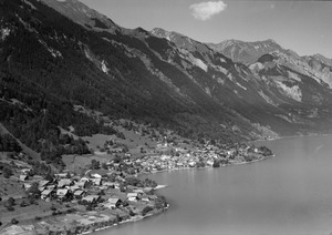
Oberried am Brienzersee is located in the Bernese Oberland region of Switzerland. It sits on the north shore of Lake Brienz. The highest mountain in the municipality is the Tannhorn, which is 2,221 meters (7,287 feet) tall.
The municipality includes the areas of Dörfli, Mehrendorf, and Ebligen along the lake shore. From there, the land rises up into the high mountains, known as the Alps. Besides the Tannhorn, other mountains like the Augstmatthorn and Riederengrat are also part of Oberried.
Oberried covers an area of about 20 square kilometers (7.7 square miles). A large part of this land, about 38.2%, is used for farming. Forests cover another big part, about 43.3% of the area.
About 2.4% of the land has buildings or roads. A small part, 0.4%, is covered by rivers or lakes. The remaining 15.2% is unproductive land, meaning it's too rocky or has too much vegetation to be used for farming or building.
In 2010, Oberried joined a new administrative area called Verwaltungskreis Interlaken-Oberhasli. This change happened after its old district, Amtsbezirk Interlaken, was closed.
Coat of Arms of Oberried
The blazon (official description) of Oberried's municipal coat of arms is: Argent a Semi Ibex rampant Sable langued Gules and a Chief Vert. This means it shows a black ibex (a type of wild goat) on a silver background. Above the ibex is a green band.
The green band symbolizes the marshy land (ried in German) from which the municipality gets its name. On Oberried's coat of arms, the green band is above (ober in German) the ibex. For the nearby village of Niederried, which means "lower Ried," the green band is below the ibex. This makes the coat of arms an example of canting arms, where the design hints at the name.
Population and Demographics
Oberried am Brienzersee has a population of about 482 people (as of December 2010). In 2010, about 8.3% of the people living there were foreign nationals. Over the past ten years (2000-2010), the population has slightly decreased.
Most people in Oberried (about 94.8% in 2000) speak German as their main language. A smaller number of people speak Italian (1.0%) or Dutch (1.0%). There are also a few people who speak French or Romansh.
In 2008, the population was almost evenly split between males (49.4%) and females (50.6%). Most residents are Swiss citizens.
About 41.6% of the people living in Oberried in 2000 were also born there. Another 31.5% were born in the same canton (Bern). About 15.3% were born elsewhere in Switzerland, and 9.5% were born outside of Switzerland.
As of 2010, children and teenagers (ages 0–19) make up 17.2% of the population. Adults (ages 20–64) make up 62.7%, and seniors (over 64 years old) make up 20.1%.
In 2000, there were 192 single people in the municipality. There were 242 married people, 31 widows or widowers, and 20 divorced individuals.
Also in 2000, there were 85 households with only one person. There were 10 households with five or more people. Most apartments (50.9%) were lived in all year round. About 39.1% were used seasonally, like vacation homes, and 10.0% were empty.
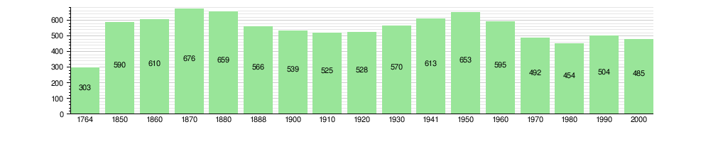
The chart below shows how the population of Oberried has changed over many years:
Important Heritage Sites

The farm house at Platzli 83 is a very important building in Switzerland. It is listed as a heritage site of national significance. This means it's a special place that is protected because of its historical or cultural importance.
Economy and Jobs
In 2011, Oberried am Brienzersee had a very low unemployment rate of 0.92%. This means almost everyone who wanted a job had one.
As of 2008, there were 152 people working in the municipality. These jobs were divided into three main types:
- Primary sector: 27 people worked in this sector, which includes farming, fishing, and forestry. There were about 10 businesses in this area.
- Secondary sector: 28 people worked in this sector, which includes manufacturing and construction. There were 6 businesses here.
- Tertiary sector: 97 people worked in this sector, which includes services like tourism, healthcare, and education. There were 13 businesses in this area.
Overall, 229 residents of Oberried had jobs. About 41.5% of these workers were female.
In 2008, there were 118 full-time equivalent jobs. This means if you add up all the hours worked, it's like 118 people working full-time.
- In the primary sector, there were 13 full-time jobs, mostly in agriculture.
- In the secondary sector, there were 27 full-time jobs, mostly in manufacturing.
- In the tertiary sector, there were 78 full-time jobs. These included jobs in sales, hotels, restaurants, education, and especially healthcare (66.7%).
In 2000, 78 workers came into Oberried for their jobs, while 160 workers left the municipality to work elsewhere. This means more people leave Oberried for work than come in. About 16.2% of working people used public transportation to get to work, and 54.1% used a private car.
Religion in Oberried
Based on the 2000 census, most people in Oberried belong to a Christian church. About 10.5% were Roman Catholic, and 76.5% belonged to the Swiss Reformed Church.
A smaller number of people (about 3.30%) belonged to other Christian churches. About 1.44% of the population was Islamic. There was also one person who was Buddhist and one who was Hindu. About 7.84% of the people said they didn't belong to any church, or they were agnostic or atheist.
Education and Schools
In Oberried am Brienzersee, about 45.4% of the population has finished non-mandatory upper secondary education. This is like high school. About 8.2% have gone on to higher education, such as a university or a specialized college (a Fachhochschule).
The school system in the Canton of Bern works like this:
- First, there's one year of non-required Kindergarten.
- Then, six years of Primary school, which everyone must attend.
- After that, three years of required lower Secondary school. Students are grouped based on their abilities.
- After lower Secondary, students can choose to continue their schooling or start an apprenticeship (learning a trade on the job).
During the 2010–11 school year, 36 students attended classes in Oberried. There was one kindergarten class with 17 students. About 11.8% of these kindergarten students spoke a different language at home than the one used in the classroom. The municipality also had one primary class with 19 students. About 10.5% of these primary students had a different mother language.
In 2000, 2 students came to Oberried from other municipalities for school. At the same time, 17 residents of Oberried went to schools outside the municipality.
Transportation in Oberried
Oberried am Brienzersee has two train stations: Oberried am Brienzersee station and Ebligen station. Both are on the Zentralbahn railway company's Brünig line. Regio trains run every hour between Interlaken and Meiringen, stopping at these stations.
You can also reach the municipality by car and by boat on the lake. In winter, train tracks or the main road can sometimes be blocked by avalanches. When this happens, the boats, which usually only run in summer, will carry passengers during the winter too.
There's a special bridge at Hirscherengraben on the road towards Brienz. It's built in a way that if an avalanche hits it, the bridge is designed to be carried directly into Lake Brienz. In some winters, avalanches have destroyed this bridge several times. These avalanches start high up on Brienz Ridge, nearly 2,000 meters (6,562 feet) above sea level. They often thunder all the way down to the lake, which is at 564 meters (1,850 feet) above sea level. The horizontal distance they cover is only about 2,300 meters (7,546 feet).
See also
 In Spanish: Oberried am Brienzersee para niños
