Old Town, Maine facts for kids
Quick facts for kids
Old Town, Maine
|
|||
|---|---|---|---|
|
|||

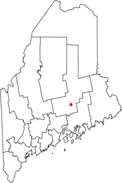
Location in the state of Maine
|
|||
| Country | United States | ||
| State | Maine | ||
| County | Penobscot | ||
| Settled | 1774 | ||
| Incorporated (town) | March 16, 1840 | ||
| Incorporated (city) | March 30, 1891 | ||
| Area | |||
| • Total | 43.24 sq mi (111.98 km2) | ||
| • Land | 38.81 sq mi (100.52 km2) | ||
| • Water | 4.43 sq mi (11.46 km2) | ||
| Elevation | 108 ft (33 m) | ||
| Population
(2020)
|
|||
| • Total | 7,431 | ||
| • Density | 191.47/sq mi (73.93/km2) | ||
| Time zone | UTC−5 (Eastern (EST)) | ||
| • Summer (DST) | UTC−4 (EDT) | ||
| ZIP Codes |
04468 (Old Town)
04489 (Stillwater) |
||
| Area code(s) | 207 | ||
| FIPS code | 23-55225 | ||
| GNIS feature ID | 0572733 | ||
Old Town is a city in Penobscot County, Maine, in the United States. In 2020, about 7,431 people lived there. The city is mostly on a large piece of land called Marsh Island. This island is surrounded by the Penobscot River to the east and the Stillwater River to the west.
Contents
History of Old Town
The Abenaki people, who are Native Americans, first lived here. They called the area Pannawambskek, which means "where the ledges spread out." This name describes the rapids and drops in the river. In the 1680s, French Jesuit missionaries set up a Christian mission here.
About a hundred years later, in 1774, English settlers arrived. The name Old Town comes from "Indian Old Town." This was the English name for the biggest village of the Penobscot people. Today, this village is known as Indian Island. It is still the home of the Penobscot Nation and is located within the city limits, but on its own island in the Penobscot River.
In 1820, the area was separated from a nearby town called Orono. Orono was named after a Penobscot sachem (a leader). The new settlement was named Old Town because it included the Penobscot village. Over time, the name "Old Town" started being used for the newer American settlement across the river.
Old Town is well-known for the Old Town Canoe Co.. This company has been making canoes and kayaks in the city for over 100 years. The city's location by the Penobscot River, with its rapids, was perfect in the 1800s. It was a great spot to use water power for mills. These mills processed huge amounts of lumber (wood) that floated down the river.
Today, many people in Old Town work for the University of Maine in Orono or the Eastern Maine Medical Center in Bangor. These are the two biggest employers nearby. Old Town is also home to the Nine Dragons Paper Holdings Limited-owned Old Town paper mill.
The city of Old Town also includes Treat-Webster Island, also known as "French Island." This is a neighborhood mostly made of homes, located on a small island in the middle of the Penobscot River. French Island is between Milford and Old Town, connected by bridges on both sides.
Geography and Climate
Old Town is located at 44°56′35″N 68°40′35″W / 44.94306°N 68.67639°W.
The city covers about 43.28 square miles (111.98 square kilometers). Most of this area is land, with about 4.43 square miles (11.46 square kilometers) being water. Old Town's main business area is on an island. The city gets its water from the Stillwater River and the Penobscot River.
A small area north of Stillwater Avenue is called "Stillwater" by the United States Postal Service. It has its own post office and ZIP code. However, the Census Bureau counts this area as part of Old Town.
Major roads like Interstate 95 and U. S. Route 2 pass through the city. Old Town borders several other towns, including Orono to the south and Milford to the east.
Climate in Old Town
Old Town has a humid continental climate. This means it has big changes in temperature throughout the year. Summers are warm to hot and often humid. Winters are cold, sometimes very cold.
| Climate data for Old Town, Maine | |||||||||||||
|---|---|---|---|---|---|---|---|---|---|---|---|---|---|
| Month | Jan | Feb | Mar | Apr | May | Jun | Jul | Aug | Sep | Oct | Nov | Dec | Year |
| Mean daily maximum °F (°C) | 29 (−2) |
31 (−1) |
41 (5) |
53 (12) |
66 (19) |
75 (24) |
80 (27) |
78 (26) |
69 (21) |
58 (14) |
45 (7) |
32 (0) |
55 (13) |
| Mean daily minimum °F (°C) | 10 (−12) |
11 (−12) |
22 (−6) |
33 (1) |
43 (6) |
52 (11) |
58 (14) |
56 (13) |
49 (9) |
39 (4) |
29 (−2) |
16 (−9) |
35 (2) |
| Average precipitation inches (mm) | 3.2 (81) |
2.6 (66) |
3.2 (81) |
3.4 (86) |
3.1 (79) |
3.4 (86) |
3.1 (79) |
2.9 (74) |
3.6 (91) |
3.8 (97) |
4 (100) |
3.1 (79) |
39.6 (1,010) |
| Source: Weatherbase | |||||||||||||
People of Old Town
| Historical population | |||
|---|---|---|---|
| Census | Pop. | %± | |
| 1840 | 2,342 | — | |
| 1850 | 3,087 | 31.8% | |
| 1860 | 3,860 | 25.0% | |
| 1870 | 4,529 | 17.3% | |
| 1880 | 3,395 | −25.0% | |
| 1890 | 5,312 | 56.5% | |
| 1900 | 5,763 | 8.5% | |
| 1910 | 6,317 | 9.6% | |
| 1920 | 6,956 | 10.1% | |
| 1930 | 7,266 | 4.5% | |
| 1940 | 7,688 | 5.8% | |
| 1950 | 8,261 | 7.5% | |
| 1960 | 8,626 | 4.4% | |
| 1970 | 9,057 | 5.0% | |
| 1980 | 8,422 | −7.0% | |
| 1990 | 8,317 | −1.2% | |
| 2000 | 8,130 | −2.2% | |
| 2010 | 7,840 | −3.6% | |
| 2020 | 7,431 | −5.2% | |
| U.S. Decennial Census | |||
2010 Census Information
In 2010, there were 7,840 people living in Old Town. There were 3,382 households, which are groups of people living together in one home. About 24.8% of these households had children under 18.
Most of the people (93.1%) were White. There were also smaller groups of African American, Native American, and Asian people. About 1.3% of the population was Hispanic or Latino.
The average age in the city was 33 years old. About 17.9% of residents were under 18. Also, 20.4% were between 18 and 24, and 13.8% were 65 or older. Slightly more than half of the residents (51.7%) were female.
Education
Old Town is part of Regional School Unit (RSU) #34. This school district includes the towns of Alton, Bradley, and Old Town.
RSU #34 has five schools:
- Alton Elementary School
- Viola Rand Elementary School
- Old Town Elementary School
- Leonard Middle School
- Old Town High School
In 2006–2007, Old Town High School changed its mascot from the Old Town Indians to the Old Town Coyotes. In 2013, a project began to improve the high school's sports facilities, including the track. The school colors for Old Town are green and white.
Another school in the area is Stillwater Montessori School.
Historic Buildings
Several buildings in Old Town are listed on the National Register of Historic Places. This means they are important historical sites.
- St. Anne's Church and Mission Site: Located on Indian Island.
- St. James Episcopal Church: Designed by a famous English architect named Henry Vaughan.
- Edith Marion Patch House (also known as Braeside).
Places to Visit
- Old Town Museum
- Sewall Park on Perch Pond (this used to be called Mud Pond)
Notable People
Many interesting people have come from Old Town:
- Doris Twitchell Allen: A psychologist who started Children's International Summer Villages, a program for kids from different countries.
- Samuel Cony: He was the 31st governor of Maine.
- James Dill: A state legislator, meaning he helped make laws for the state.
- Matthew Dunlap: He served as the Maine State Auditor and the Secretary of State of Maine.
- Patty Griffin: A well-known singer-songwriter.
- Chad Hayes: An American football player who played for the University of Maine and in the NFL.
- Charles Davis Jameson: A general during the American Civil War.
- Molly Spotted Elk: An actress and dancer.
- Tabitha King: An author, and the wife of famous author Stephen King.
- Bud Leavitt Jr.: A longtime editor and writer for The Bangor Daily News, and a television host.
- Dick MacPherson: He was the head coach for the New England Patriots football team.
- William F. Milliken Jr.: An engineer and racing car driver.
- Nick Noonan: A founding member of the music group Karmin.
- David Richard Porter: A YMCA youth leader and the first person from Maine to become a Rhodes Scholar (a special scholarship for studying at Oxford University).
- Charles W. Roberts: Another general from the Civil War.
- Aaron Y. Ross: A famous character from the 'Old West'.
- Theresa Secord: She started the Maine Indian Basketmakers Alliance.
- George P. Sewall: He was the speaker of the Maine House of Representatives.
- Joseph Sewall: He was the president of the Maine Senate.
- Andrew Sockalexis: An Olympic athlete.
- Louis "Chief" Sockalexis: The first Native American to play in major league baseball.
- Mary Ellen St. John: She was crowned Miss Maine in 1954.
- Gary Thorne: A well-known sports broadcaster.
- Walter E. Webber: A lawyer and a Mason.
- George F. Wilson: A catcher who played baseball for the Detroit Tigers and Boston Red Sox.
Images for kids
See also
 In Spanish: Old Town (Maine) para niños
 | Audre Lorde |
 | John Berry Meachum |
 | Ferdinand Lee Barnett |


