
Bristol, Maine facts for kids
Quick facts for kids
Bristol, Maine
|
|
|---|---|

Pemaquid Point Lighthouse
|
|

Location in Lincoln County and the state of Maine.
|
|
| Country | United States |
| State | Maine |
| County | Lincoln |
| Incorporated | 1765 |
| Area | |
| • Total | 78.23 sq mi (202.61 km2) |
| • Land | 33.99 sq mi (88.03 km2) |
| • Water | 44.24 sq mi (114.58 km2) |
| Elevation | 121 ft (37 m) |
| Population
(2020)
|
|
| • Total | 2,834 |
| • Density | 83/sq mi (32.2/km2) |
| Time zone | UTC-5 (Eastern (EST)) |
| • Summer (DST) | UTC-4 (EDT) |
| ZIP Codes | |
| Area code(s) | 207 |
| FIPS code | 23-07485 |
| GNIS feature ID | 0582369 |
Bristol, Maine, was once known as Pemaquid (/ˈpɛməkwɪd/) from 1632 to 1765. Today, Pemaquid is a village within the town. Bristol is a town in Lincoln County, Maine, United States. In 2020, about 2,834 people lived there.
Bristol is a popular spot for fishing and vacations. It includes several small villages like New Harbor, Pemaquid, Round Pond, Bristol Mills, and Chamberlain. You can also find the Pemaquid Archeological Site here, which is a very important historical place in the U.S. Long ago, in the 1600s and early 1700s, this area was considered part of Acadia by the French.
Contents
A Look Back: Bristol's History
Bristol was originally the land of the Wawenock (or Walinakiak) Abenaki people. This area was a very important and often fought-over frontier settlement. The English started fishing here around 1625. They soon built a trading post at Pemaquid Point to trade furs all year. In 1631, two merchants from Bristol, England, Robert Aldsworth and Gyles Elbridge, were given control of the Pemaquid area by the Plymouth Council.
Early Challenges: Pirates and Storms
A village and a wooden fort were built in Pemaquid. In 1632, the pirate Dixie Bull attacked and robbed Pemaquid. A few years later, in 1635, a huge storm called the Great Colonial Hurricane hit. It sank the ship Angel Gabriel near the settlement, and some people on board drowned.
In 1664, the Duke of York (who later became King James II) claimed Pemaquid as his land. He also claimed other areas like Sagadahoc and the recently taken New Amsterdam. To help make New Amsterdam more English, the governor, Sir Edmund Andros, moved some Dutch people to Pemaquid. Pemaquid was then renamed Jamestown after its royal owner. By 1665, the village had about 30 houses.
Conflicts and Forts
King Philip's War (1676)
During King Philip's War, in 1676, Native American groups attacked and burned English settlements along the coast, including Pemaquid. The next year, a new wooden fort called Fort Charles was built for defense.
King William's War (1689-1696)

During King William's War, which was one of the French and Indian Wars, Fort Charles and the village were attacked and destroyed in 1689. This attack was carried out by French forces from Castine, Maine. The people of Pemaquid were either killed or taken as prisoners.
By 1692, the English took control of the area again. Sir William Phipps ordered a new fort to be built. This one was made of stone and named Fort William Henry after King William III of England.
However, on August 14–15, 1696, a famous French commander named Pierre Le Moyne d'Iberville captured and destroyed Fort William Henry. He led a combined force of French and Native Americans. The fort's commander, Captain Pascoe Chubb, surrendered. Iberville killed three soldiers and sent the other 92 back to Boston. In response, Benjamin Church was sent from Boston to attack Acadia.
Pirate Attack (1717)
In May 1717, a pirate group captured a small ship (a sloop) near Pemaquid. These pirates had come from Monhegan, where they had been waiting for another pirate ship, the Whydah, which had sunk in a storm. The pirates then attacked other ships in the area, including the one they used at Pemaquid. They eventually left the area, abandoning their captured ships and most of their prisoners.
Father Rale's War (1729-1747)
During Father Rale's War, this location was a meeting point for Native Americans and French forces. They would return prisoners they had taken from Pemaquid and nearby areas during the war.
Colonel David Dunbar, who was in charge of the King's Woods, rebuilt the fort between 1729 and 1730. He renamed it Fort Frederick. He also renamed the town Harrington, after the Earl of Harrington, who had helped with a treaty in 1729.
During King George's War, Fort Frederick was attacked twice in 1747 but held strong. However, in 1759, after the French and Indian Wars ended, the fort was no longer needed.
American Revolution and Beyond
In 1775, during the Revolutionary War, the town took apart the fort. They did this to stop it from becoming a British stronghold. In 1902, the state of Maine bought the site. In 1908, they rebuilt the tower of Fort William Henry, using many of the original stones. In 1993, the site was recognized as a National Historic Landmark.
On June 21, 1765, the town was officially named Bristol. It was named after the home port of the people who owned the Pemaquid land grant.
During the War of 1812, a naval battle happened off Pemaquid Point. On September 5, 1813, the American ship USS Enterprise captured the British ship HMS Boxer. Over time, parts of Bristol were separated to form new towns: Nobleboro in 1788, Bremen in 1828, Damariscotta in 1848, and South Bristol in 1915. Today, Bristol is a popular place for tourists to visit.
Bristol's Location and Landscape
Bristol is located on the Pemaquid Peninsula, which stretches out into the Gulf of Maine and the Atlantic Ocean. The town has a total area of about 78.23 square miles (202.61 square kilometers). About 33.99 square miles (88.03 square kilometers) is land, and 44.24 square miles (114.58 square kilometers) is water.
People of Bristol
| Historical population | |||
|---|---|---|---|
| Census | Pop. | %± | |
| 1790 | 516 | — | |
| 1800 | 2,062 | 299.6% | |
| 1810 | 2,753 | 33.5% | |
| 1820 | 2,946 | 7.0% | |
| 1830 | 2,450 | −16.8% | |
| 1840 | 2,945 | 20.2% | |
| 1850 | 2,931 | −0.5% | |
| 1860 | 3,335 | 13.8% | |
| 1870 | 2,916 | −12.6% | |
| 1880 | 3,196 | 9.6% | |
| 1890 | 2,821 | −11.7% | |
| 1900 | 2,572 | −8.8% | |
| 1910 | 2,415 | −6.1% | |
| 1920 | 1,419 | −41.2% | |
| 1930 | 1,413 | −0.4% | |
| 1940 | 1,355 | −4.1% | |
| 1950 | 1,476 | 8.9% | |
| 1960 | 1,441 | −2.4% | |
| 1970 | 1,721 | 19.4% | |
| 1980 | 2,095 | 21.7% | |
| 1990 | 2,326 | 11.0% | |
| 2000 | 2,644 | 13.7% | |
| 2010 | 2,755 | 4.2% | |
| 2020 | 2,834 | 2.9% | |
| U.S. Decennial Census | |||
In 2000, the average income for a household in Bristol was $38,400 per year. For families, the average income was $45,184. About 6.0% of the population lived below the poverty line. This included 5.9% of those under 18 and 6.8% of those 65 or older.
Bristol's Population in 2010
According to the 2010 census, 2,755 people lived in Bristol. There were 1,309 households and 828 families. The town had about 81.1 people per square mile (31.3 people per square kilometer). Most residents (98.4%) were White.
About 18.6% of households had children under 18. Most households (53.2%) were married couples. The average household had 2.09 people, and the average family had 2.55 people. The median age in Bristol was 54.1 years. About 15.2% of residents were under 18, and 28.5% were 65 or older. There were slightly more females (50.6%) than males (49.4%).
Places to Visit in Bristol
- Fishermen's Museum
- Fort William Henry
- Granite Hall Store
- Harrington Meeting House
- Loudville Church on Louds Island
- Pemaquid Archeological Site
- Pemaquid Point Lighthouse
Famous People from Bristol
- Thomas Drummond, a judge
- David Hanna, an artist
- Marcus Hanna, a well-known lighthouse keeper
- Robert Livingston Ireland, Jr., a businessman (who spent summers here)
- William North, a senator from New York
- Samoset, an Abenaki leader
- Joshua Soule, a Methodist bishop
- Elizabeth Upham Yates, a supporter of women's right to vote and a missionary
Images for kids
-
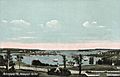
Pemaquid Harbor c. 1908
-
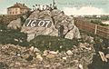
Fort Rock c. 1906
-
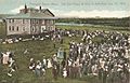
Old Fort House in 1909
-
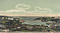
New Harbor c. 1905


See Also
 In Spanish: Bristol (Maine) para niños
