Pembina, North Dakota facts for kids
Quick facts for kids
Pembina, North Dakota
|
|
|---|---|
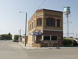
Building and water tower in Pembina
|
|
| Motto(s):
"Oldest Settlement in the Dakota Territories"
|
|
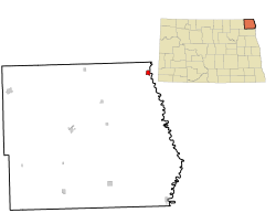
Location of Pembina, North Dakota
|
|
| Country | United States |
| State | North Dakota |
| County | Pembina |
| Founded | 1797 (Officially 1843) |
| Area | |
| • Total | 0.81 sq mi (2.11 km2) |
| • Land | 0.81 sq mi (2.09 km2) |
| • Water | 0.01 sq mi (0.02 km2) |
| Elevation | 791 ft (241 m) |
| Population
(2020)
|
|
| • Total | 512 |
| • Estimate
(2022)
|
504 |
| • Density | 634.45/sq mi (245.03/km2) |
| Time zone | UTC−6 (Central (CST)) |
| • Summer (DST) | UTC−5 (CDT) |
| ZIP code |
58271
|
| Area code(s) | 701 |
| FIPS code | 38-61580 |
| GNIS feature ID | 1036216 |
Pembina is a small city in Pembina County, North Dakota, United States. In 2020, 512 people lived there. Pembina is special because it's one of the oldest European-American communities in the Dakotas. It's located only 2 miles (3.2 km) south of the border between Canada and the United States.
Interstate 29 runs past Pembina. This highway goes north to the Canadian border at Emerson, Manitoba. It also goes south to cities like Grand Forks and Fargo. The Pembina–Emerson Border Crossing is a very busy place where people and goods cross the border. It's one of the busiest crossings between Canada and the U.S.
For a long time, different Native American groups lived in the Pembina area. These included the Lakota (also called Sioux), the Chippewa (Ojibwe), and the Assiniboine. European fur traders arrived in the 16th century. The Hudson's Bay Company (HBC) set up a fur-trading post here in 1797. This was the first permanent European settlement in the Dakotas.
Pembina was officially founded in 1843. In 1851, the first post office in what is now North Dakota opened here. Pembina was the biggest town in North Dakota in 1860. It was the county seat from 1867 to 1911.
Contents
What Does Pembina Mean?
The name Pembina comes from an Ojibwe word. It refers to the Viburnum edule plant. This plant is a bushy type with bright red berries that grows in the area. People in the 1800s often translated the word as "summer berry" or "high cranberry."
History of Pembina
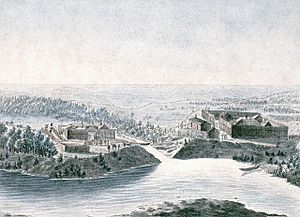
The Pembina area was a meeting point for different Native American tribes. These included the Lakota, Chippewa, and Assiniboine. They often competed for control of the land. When the French arrived in the late 1600s, they brought firearms. This increased the conflict between the tribes. The first Europeans known to visit Pembina were the French La Vérendrye family in the early 1700s.
Pembina has a long history of European contact, over 200 years. It started as a fur trading post. Traders exchanged goods with Native Americans for furs and plains bison products. Many European trappers married Native women. Their children became known as the Métis. They were a mix of European and Native cultures.
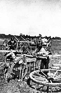
The settlement's history is linked to many important events. These include the Red River Colony and the Red River Rebellion. For much of the 1800s, Métis families used Red River ox carts. They traveled into the Great Plains to hunt bison. These trade routes became known as the Red River Trails.
Early Trading Posts
Many fur trading posts were built in the Pembina area:
- Between 1784 and 1789, Peter Grant of the North West Company built a post. It was on the east side of the Red River.
- In 1797, Jean Baptiste Chaboillez of the North West Company built another post. This one was on the south bank of the Pembina River.
- From 1800 to 1805, the XY Company had a post nearby. The North West Company later took it over.
- In 1801, Alexander Henry the younger of the North West Company built a post. It was across the river from Chaboillez's post.
- By 1793, the Hudson's Bay Company (HBC) had a small post called Fort Skene. It was rebuilt in 1801. The HBC post kept operating until at least 1870.
- In 1812, settlers from the Red River Colony built Fort Daer. It was on the site of Chaboillez's old post.
- In the 1820s, explorer David Thompson found that Pembina was south of the 49th parallel. This meant it was part of the United States.
- In the 1840s, Norman Kittson of the American Fur Company had a trading spot.
- In 1872, Canadian and American groups met in Pembina. They surveyed and marked the Canada-U.S. border.
Fort Pembina
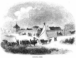
After the American Civil War, there was unrest among Native Americans. The state of Minnesota asked the U.S. government to build a fort. This fort would help protect against attacks, especially from the Lakota (Sioux).
So, Fort Pembina was built. It was finished on July 8, 1870. The fort was located about 1.5 miles (2.4 km) south of the settlement. It was first called Fort Thomas. On September 6, 1870, its name was changed to Fort Pembina. A fire badly damaged the fort in 1895. It was then closed on August 16, 1895, and later sold.
Métis People in Pembina
The Métis people had strong ties to Pembina in the 1800s. Many Métis bison hunters and traders lived or visited here. In 1818, the Roman Catholic Church started a mission in Pembina. Its goal was to convert buffalo hunters and Native Americans. Church records show that many Métis were baptized.
Recent History
In 1962, a bus company called Motor Coach Industries opened a factory in Pembina. They built coach buses there.
Pembina officially became a city in 1967.
The famous American author Louise Erdrich has written about the Pembina River. She also writes about the Pembina Band of the Ojibwe Indians. Her books often celebrate their unique heritage.
Even though Pembina is small, it once had its own TV station. This was KCND-TV channel 12, from 1960 to 1975. The station mainly aimed its broadcasts at Winnipeg, Canada. Later, Canadian interests bought the station. It moved to Winnipeg and became CKND-TV channel 9.
Pembina's population has never been more than 1,000 people.
Motor Coach Industries had planned to close its Pembina factory in 2022. However, they changed their mind in November 2023.
Geography and Climate
Pembina is in the very northeastern corner of North Dakota. It's where the Red River of the North and the Pembina River meet. The city of St. Vincent, Minnesota, is right next door, across the Red River. The town of Emerson, Manitoba, Canada, is just north of Pembina.
The city has a total area of about 0.77 square miles (2.0 km²). All of this area is land.
Pembina has a humid continental climate. This means it has warm summers and very cold, dry winters.
| Climate data for Pembina, North Dakota (1991–2020 normals, extremes 1898–present) | |||||||||||||
|---|---|---|---|---|---|---|---|---|---|---|---|---|---|
| Month | Jan | Feb | Mar | Apr | May | Jun | Jul | Aug | Sep | Oct | Nov | Dec | Year |
| Record high °F (°C) | 50 (10) |
61 (16) |
75 (24) |
99 (37) |
106 (41) |
103 (39) |
109 (43) |
104 (40) |
102 (39) |
93 (34) |
78 (26) |
62 (17) |
109 (43) |
| Mean maximum °F (°C) | 37.0 (2.8) |
38.5 (3.6) |
52.1 (11.2) |
71.0 (21.7) |
85.0 (29.4) |
88.8 (31.6) |
89.3 (31.8) |
90.7 (32.6) |
86.2 (30.1) |
75.5 (24.2) |
53.7 (12.1) |
39.3 (4.1) |
93.3 (34.1) |
| Mean daily maximum °F (°C) | 12.7 (−10.7) |
17.9 (−7.8) |
31.4 (−0.3) |
50.0 (10.0) |
64.9 (18.3) |
74.7 (23.7) |
78.9 (26.1) |
78.1 (25.6) |
68.6 (20.3) |
52.0 (11.1) |
33.6 (0.9) |
19.5 (−6.9) |
48.5 (9.2) |
| Daily mean °F (°C) | 4.0 (−15.6) |
8.2 (−13.2) |
22.2 (−5.4) |
39.5 (4.2) |
53.3 (11.8) |
63.9 (17.7) |
67.9 (19.9) |
66.0 (18.9) |
56.7 (13.7) |
42.2 (5.7) |
25.8 (−3.4) |
11.6 (−11.3) |
38.4 (3.6) |
| Mean daily minimum °F (°C) | −4.8 (−20.4) |
−1.6 (−18.7) |
12.9 (−10.6) |
28.9 (−1.7) |
41.7 (5.4) |
53.1 (11.7) |
57.0 (13.9) |
53.9 (12.2) |
44.9 (7.2) |
32.3 (0.2) |
18.0 (−7.8) |
3.6 (−15.8) |
28.3 (−2.1) |
| Mean minimum °F (°C) | −28 (−33) |
−23.5 (−30.8) |
−12.5 (−24.7) |
12.3 (−10.9) |
26.0 (−3.3) |
38.7 (3.7) |
45.0 (7.2) |
41.8 (5.4) |
30.6 (−0.8) |
17.1 (−8.3) |
−1.7 (−18.7) |
−19.2 (−28.4) |
−30.2 (−34.6) |
| Record low °F (°C) | −48 (−44) |
−46 (−43) |
−39 (−39) |
−12 (−24) |
9 (−13) |
22 (−6) |
33 (1) |
25 (−4) |
12 (−11) |
−2 (−19) |
−39 (−39) |
−44 (−42) |
−48 (−44) |
| Average precipitation inches (mm) | 0.53 (13) |
0.39 (9.9) |
0.77 (20) |
1.07 (27) |
3.23 (82) |
4.06 (103) |
3.32 (84) |
2.56 (65) |
2.78 (71) |
1.83 (46) |
0.91 (23) |
0.64 (16) |
22.09 (561) |
| Average precipitation days (≥ 0.01 in) | 7.4 | 6.4 | 6.4 | 6.0 | 11.1 | 13.3 | 10.8 | 9.5 | 8.9 | 8.4 | 6.8 | 9.0 | 104.0 |
| Source: NOAA | |||||||||||||
Population Information
| Historical population | |||
|---|---|---|---|
| Census | Pop. | %± | |
| 1880 | 287 | — | |
| 1890 | 670 | 133.4% | |
| 1900 | 929 | 38.7% | |
| 1910 | 717 | −22.8% | |
| 1920 | 802 | 11.9% | |
| 1930 | 551 | −31.3% | |
| 1940 | 703 | 27.6% | |
| 1950 | 640 | −9.0% | |
| 1960 | 625 | −2.3% | |
| 1970 | 741 | 18.6% | |
| 1980 | 673 | −9.2% | |
| 1990 | 642 | −4.6% | |
| 2000 | 642 | 0.0% | |
| 2010 | 592 | −7.8% | |
| 2020 | 512 | −13.5% | |
| 2022 (est.) | 504 | −14.9% | |
| U.S. Decennial Census 2020 Census |
|||
Pembina's People in 2010
In 2010, there were 592 people living in Pembina. They lived in 237 households. Most people were of European American background.
About 29% of households had children under 18. Over half (57.4%) were married couples. The average household had 2.50 people.
The average age in the city was 40.6 years old. About 26% of residents were under 18. Around 14% were 65 or older. There were slightly more females (51.7%) than males (48.3%).
Places to Visit
- Dumoulin Mission and Cemetery Site: This historical site is north of Pembina.
- Fort Daer Landing And Recreation Area: A place for outdoor activities.
- Grace Episcopal Church (Pembina, North Dakota)
- Pembina State Museum: This museum has exhibits about Pembina's history. It shows how it was one of the first European settlements.
- Pembina State Park: A protected area where the Red and Pembina Rivers meet.
- Icelandic Evangelical Lutheran Church
- United States Customs House and Post Office – Pembina
See also
 In Spanish: Pembina (Dakota del Norte) para niños


