Pend Oreille County, Washington facts for kids
Quick facts for kids
Pend Oreille County
|
|||
|---|---|---|---|

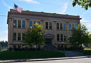
Pend Oreille County Courthouse (September 2014)
|
|||
|
|||

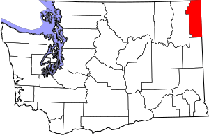
Location within the U.S. state of Washington
|
|||
 Washington's location within the U.S. |
|||
| Country | |||
| State | |||
| Founded | March 1, 1911 | ||
| Named for | Pend d'Oreilles people | ||
| Seat | Newport | ||
| Largest city | Newport | ||
| Area | |||
| • Total | 1,425 sq mi (3,690 km2) | ||
| • Land | 1,400 sq mi (4,000 km2) | ||
| • Water | 25 sq mi (60 km2) 1.8%% | ||
| Population
(2020)
|
|||
| • Total | 13,401 | ||
| • Estimate
(2023)
|
14,361 |
||
| • Density | 9.3/sq mi (3.6/km2) | ||
| Time zone | UTC−8 (Pacific) | ||
| • Summer (DST) | UTC−7 (PDT) | ||
| Congressional district | 5th | ||
Pend Oreille County (pronounced POND-uh-RAY) is a special area, like a large region, in the northeast corner of Washington. It is right next to the border with Canada.
In 2020, about 13,401 people lived here. The main town and biggest city is Newport.
Pend Oreille County was created on March 1, 1911. It was formed from a part of Stevens County. It is the newest of all 39 counties in Washington state. The county got its name from the Pend d'Oreilles tribe. This tribe was known for wearing large shell earrings. The name "Pend d'oreille" comes from French and means "hangs from the ear."
Contents
Geography
Pend Oreille County is located in the northeast part of Washington state. It covers about 1,425 square miles (3,690 square kilometers). Most of this area is land, about 1,400 square miles (3,626 square kilometers). The rest, about 25 square miles (65 square kilometers), is water, like lakes and rivers.
Highways and Roads
Several important roads, called highways, help people travel through Pend Oreille County. These include:
 U.S. Route 2
 State Route 20
 State Route 31
 State Route 41
 State Route 211
- International Selkirk Loop
Neighboring Areas
Pend Oreille County shares its borders with other counties and even another country!
- Boundary County, Idaho – to the east
- Bonner County, Idaho – to the east
- Spokane County – to the south
- Stevens County – to the west
- Central Kootenay Regional District, British Columbia – to the north (in Canada)
Protected Natural Areas
Parts of these beautiful natural areas are found within Pend Oreille County:
- Colville National Forest
- Pacific Northwest National Scenic Trail
- Kaniksu National Forest
- Little Pend Oreille National Wildlife Refuge
Population Facts
| Historical population | |||
|---|---|---|---|
| Census | Pop. | %± | |
| 1920 | 6,363 | — | |
| 1930 | 7,155 | 12.4% | |
| 1940 | 7,156 | 0.0% | |
| 1950 | 7,413 | 3.6% | |
| 1960 | 6,914 | −6.7% | |
| 1970 | 6,025 | −12.9% | |
| 1980 | 8,580 | 42.4% | |
| 1990 | 8,915 | 3.9% | |
| 2000 | 11,732 | 31.6% | |
| 2010 | 13,001 | 10.8% | |
| 2020 | 13,401 | 3.1% | |
| 2023 (est.) | 14,361 | 10.5% | |
| U.S. Decennial Census 1790–1960 1900–1990 1990–2000 2010–2020 |
|||
In 2010, about 13,001 people lived in Pend Oreille County. There were 5,479 households, which are groups of people living together. The population density was about 9.3 people per square mile.
Most people in the county were Caucasian (91.6%). There were also American Indian (3.8%), Asian (0.6%), and Black or African American (0.4%) residents. About 3.0% of the population was of Hispanic or Latino origin.
The average age of people in the county was 47.8 years old.
Communities
Cities
- Newport (This is the county seat, meaning it's where the main government offices are.)
Towns
Unincorporated Communities
These are smaller places that are not officially cities or towns.
See also
 In Spanish: Condado de Pend Oreille para niños


