
Percuil River facts for kids
Quick facts for kids Percuil River |
|
|---|---|

The Percuil River
|
|
| Country | United Kingdom |
| Region | Cornwall |
| Physical characteristics | |
| Main source | Treworlas Philleigh 45 m (148 ft) 50°12′28″N 4°57′23″W / 50.2077°N 4.9565°W |
| River mouth | Carrick Roads Falmouth Bay 50°09′07″N 5°01′16″W / 50.152°N 5.021°W |
| Length | 11 km (6.8 mi) |
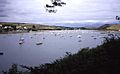
The Percuil River is a special kind of river mouth called an estuary. It's also a stream that flows through the southern part of the Roseland Peninsula in Cornwall, UK. This river is one of three main tidal creeks that feed into the larger River Fal. On its western side, you'll find the small port and popular holiday spot of St Mawes. A ferry called the Place Ferry connects St Mawes to Place Creek on the eastern side. This ferry is often used by people walking the famous South West Coast Path.
Contents
Understanding the Percuil River's Geography
The Percuil River is one of three big tidal creeks that flow into the River Fal. The Fal then empties into a deep natural harbor called Carrick Roads and finally into Falmouth Bay. The Percuil River is actually a "ria." This is a special name for a river valley that has been flooded by the sea.
How the River Valley Formed
The Percuil River valley began forming a very long time ago, during the Quaternary period. During a warm period called the Ipswichian interglacial, sea levels rose. This caused the valley to flood. Later, during the Devensian glacial period, sea levels dropped a lot. They were about 42 meters lower than they are today! The River Fal then carved a deep, winding valley into the rock.
As the climate got warmer again, sea levels rose once more. The cold arctic tundra turned into forests. The rising sea eventually covered these trees, leaving behind layers of peat. You can still see these peat deposits in places like Maenporth and Falmouth.
River Length and Surroundings
The Percuil River, including both its stream and estuary parts, is about 11 kilometers (7 miles) long. It starts north of the A3078 road, near a place called Treworthal. The highest point where the tide reaches is at Trethern Mill. From there, the stream flows for about 6 kilometers (4 miles) before joining the River Fal. This meeting point is between Castle Point and Carricknath Point.
At Trethern Mill, the river is known as Trethem Creek. There are also four smaller creeks on the eastern side of the Percuil River. These are where small streams flow into the main estuary. From north to south, they are Polingey Creek, Pelyn Creek, Porth Creek, and Place Creek.
The estuary has steep banks, which create a safe and sheltered harbor. This is a big contrast to the open and often rough coast of Falmouth Bay and the eastern side of Roseland. The land around the river is mostly old farmland. It has good soil that is easy to drain and is used for both growing crops and raising animals. The roads, paths, and farms in the area are also very old. However, the lower eastern bank, from St Mawes Castle to Povarth Point, mostly has newer houses built in the late 20th century.
Exploring St Mawes

St Mawes is a village on the western side of the Percuil River. It was first mentioned in records in 1284. Back then, it was called Lavada or Lavousa in the Cornish language. The name suggests it might have been an early Christian settlement. Even though it had a chapel, cemetery, and holy well by 1381, St Mawes never became a full parish.
St Mawes's History as a Port
St Mawes became a borough (a town with special rights) in the early 14th century. Its quay (a landing place for boats) was first mentioned in 1539. From the Middle Ages onwards, St Mawes was a busy fishing village and port. However, it was often attacked by raiders from Brittany.
To make the sea safer, St Mawes Castle was built between 1540 and 1542. This was one of King Henry VIII's "device forts," designed to protect the coast. With the castle, fishing for crab, oysters, and pilchards grew. Local pilots could also reach incoming ships before their rivals from Falmouth.
As the port grew, other businesses appeared. These included places to make ropes (ropewalks), buildings to process pilchards (pilchard cellars), and inns. A watch-house was also set up for the coastguard service. However, the maritime industries started to decline when the railway opened to Falmouth in 1863. After that, St Mawes became more of a passenger steamer stop, a holiday spot, and a place for people to live or retire in the 20th century.
Discovering Place Creek
Opposite St Mawes, on the eastern side of the river, is a small tidal creek called Place. This is where the Place Ferry from St Mawes arrives and departs. It's also a key point for walkers on the South West Coast Path.
The Place Ferry and Its Importance
The boathouse and slipway at Place were once very busy. They were used by the Percuil and St Mawes Ferry, a steamer from Falmouth that ran twice a day, and a rowing ferry to St Mawes. Most passengers were estate workers or children going to school. As more people started using roads, the ferry service stopped. However, it restarted in the 1980s with support from the Countryside Agency. This happened after the coast path was named a National Trail.
Cellar Beach and Its Fishing History
On the southern shore of Place Creek is a sheltered spot called Cellar Beach. This beach was once where large catches of pilchards were brought ashore. The name "Cellar" refers to the place where these fish were salted. Salting preserved them for winter food for local people and for export to countries around the Mediterranean Sea. Much of the wealth of the Spry family came from their fishing boats, pilchard cellars, and boat-building businesses.
Place House and St Anthony's Church
The parish of St Anthony in Roseland is mentioned in the Domesday Book. At that time, it belonged to the Bishop of Exeter. Place House stands on the site of a small monastic cell. This cell was home to an Augustinian priory and one monk. It was established sometime after 1140, when the parish was given to the Priory of Plympton in 1288.
Place Priory was destroyed by French pirates in 1338. It was later closed down in 1538. People say that the stones from the priory were used to build St Mawes Castle. A map from 1597 shows what looks like an Elizabethan mansion on the site, owned by a Mr. Davies.
The house has been changed and made bigger over the years. In 1851, Sir Samuel Spry, who was a Member of Parliament for Bodmin, redesigned it. He gave Place House its current look, which resembles a French chateau. In front of the house, there was once a pond for a tidal mill. This mill was known to exist in 1540 and probably ground grain for the priory. It was still working in 1812. The pond was filled in around 1860 when the house was rebuilt. It is now the lawn in front of the house. During World War II, the War Office took over the house for military use.
St Anthony's church is next to Place House. The famous architectural historian Nikolaus Pevsner said it's the best example of what a Cornish parish church looked like in the 12th and 13th centuries. The church is special because it still has its original medieval cruciform (cross-shaped) design. This is despite a restoration in the 19th century by Reverend Clement Carlyon. He was hired by his cousin, Sir Thomas Spry. Carlyon rebuilt the chancel, designed the pulpit and pews, and added the floor tiles, stained glass, and new wooden roof.
A room at the back of Place House, with large, rough wooden beams, is thought to have been the rectory (the home of the church's priest). It connects to the nave (the main part of the church) by a door and a few steps.
Inside the church, there are monuments to the Spry family, who owned Place House. These include Admiral, Sir Richard Spry (1715–1775). He was a very important naval officer, serving as Commander-in-Chief of the North American Station and the Mediterranean Station. The church is a Grade II*-listed building, meaning it's very important historically. It is now looked after by the Churches Conservation Trust.
River Trade and Industries
Along the west side of the Percuil River, there are several small quays (docks). These quays served the local farms. They were also places where boats could wait for the tide to rise before going further upstream. At the very top of the estuary was Trethem Quay. Here, there was a water mill, and coal was still being unloaded well into the 20th century.
Historic Industries Along the River
At Trewince Quay, there was a lime kiln (used to make lime for building or farming) and pilchard cellars. On the opposite shore, at The Priory, there was a coal store, another lime kiln, a malthouse (for making malt from grain), and a quay. Besides the tidal mill at Point, there were two more at the heads of Polingey and Porth Creeks.
North of Place, further up the river, is Percuil. A road connects this spot to the villages of Gerrans and Portscatho. In the late 16th century, there were pilchard cellars here. During the 19th century, a malthouse and a coal store were also present. Coal, guano (a type of fertilizer), oysters, and roadstone were unloaded from barges and ketches onto the beach. This beach was also used for repairing and cleaning ships. The St Mawes steamer was met twice a day by a wagonette from Gerrans, carrying mail and passengers. The 19th-century slipway (a ramp for launching boats) still exists today. To the south, there is an oyster keep, which is a place to store live oysters.
Boat Building and Expansion
In the 19th century, there were boatyards with their own quays and pilchard cellars around Polvarth Point. At Freshwater Beach, to the north, the Peters family started a boatyard in 1790. This yard built working boats and was famous for its six-oar pilot gigs (a type of rowing boat). During World War II, D-Day landing craft were converted and maintained at Polvarth. In the 20th century, St Mawes grew along the west side of the estuary. Polvarth is now part of the village of St Mawes.
Enjoying the River: Recreation
The St Mawes to Place ferry connects the two sides of the Percuil River. This ferry is very important for people walking the South West Coast Path. This path is 630 miles (1,014 km) long and runs along the coasts of Somerset, Devon, and Cornwall, ending at Poole Harbour in Dorset. The ferry can also be used for shorter walks along the river and its creeks. It's also a way to visit nearby places like Portscatho and St Anthony Head.
Images for kids
-
The Percuil River
-
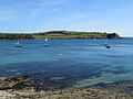
Looking across the Percuil River estuary from St Mawes
