Perry County, Alabama facts for kids
Quick facts for kids
Perry County
|
||
|---|---|---|

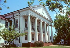
Perry County courthouse in Marion
|
||
|
||

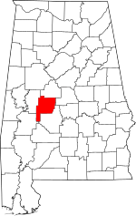
Location within the U.S. state of Alabama
|
||
 Alabama's location within the U.S. |
||
| Country | ||
| State | ||
| Founded | December 13, 1819 | |
| Named for | Oliver Hazard Perry | |
| Seat | Marion | |
| Largest city | Marion | |
| Area | ||
| • Total | 724 sq mi (1,880 km2) | |
| • Land | 720 sq mi (1,900 km2) | |
| • Water | 4.2 sq mi (11 km2) 0.6% | |
| Population
(2020)
|
||
| • Total | 8,511 | |
| • Estimate
(2023)
|
7,738 |
|
| • Density | 11.756/sq mi (4.539/km2) | |
| Time zone | UTC−6 (Central) | |
| • Summer (DST) | UTC−5 (CDT) | |
| Congressional district | 7th | |
|
||
Perry County is a county found in the Black Belt area of central Alabama. It is a state in the United States. In 2020, about 8,511 people lived there. The main town and county seat is Marion.
The county was created in 1819. It is named after Commodore Oliver Hazard Perry. He was a famous naval officer from Rhode Island. As of 2020, Perry County was the only county in Alabama without wired broadband internet.
Contents
History of Perry County
The town of Marion in Perry County was important in the Selma to Montgomery marches. These marches happened in 1965. They were a big part of the Civil Rights Movement.
In 2008, the county decided to make "Barack Obama Day" a legal holiday. This holiday is celebrated every second Monday of November.
Geography and Nature
Perry County covers about 724 square miles. Most of this area, about 720 square miles, is land. The rest, about 4.2 square miles, is water.
Main Roads in Perry County
 U.S. Highway 80
 State Route 5
 State Route 14
 State Route 61
 State Route 175
 State Route 183
 State Route 219
 State Route 289
Neighboring Counties
Perry County shares its borders with several other counties:
- Bibb County (to the north)
- Chilton County (to the northeast)
- Dallas County (to the east)
- Marengo County (to the southwest)
- Hale County (to the west)
Protected Natural Areas
Part of the Talladega National Forest is located in Perry County. This forest helps protect nature and wildlife.
People and Population
The number of people living in Perry County has changed over time. Here is a look at the population from past years:
| Historical population | |||
|---|---|---|---|
| Census | Pop. | %± | |
| 1820 | 3,646 | — | |
| 1830 | 11,490 | 215.1% | |
| 1840 | 19,086 | 66.1% | |
| 1850 | 22,285 | 16.8% | |
| 1860 | 27,724 | 24.4% | |
| 1870 | 24,975 | −9.9% | |
| 1880 | 30,741 | 23.1% | |
| 1890 | 29,332 | −4.6% | |
| 1900 | 31,783 | 8.4% | |
| 1910 | 31,222 | −1.8% | |
| 1920 | 25,373 | −18.7% | |
| 1930 | 26,385 | 4.0% | |
| 1940 | 26,610 | 0.9% | |
| 1950 | 20,439 | −23.2% | |
| 1960 | 17,358 | −15.1% | |
| 1970 | 15,388 | −11.3% | |
| 1980 | 15,012 | −2.4% | |
| 1990 | 12,759 | −15.0% | |
| 2000 | 11,861 | −7.0% | |
| 2010 | 10,591 | −10.7% | |
| 2020 | 8,511 | −19.6% | |
| 2023 (est.) | 7,738 | −26.9% | |
| U.S. Decennial Census 1790–1960 1900–1990 1990–2000 2010–2020 |
|||
What the 2020 Census Shows
The 2020 United States census counted 8,511 people in Perry County. There were 3,070 households and 1,476 families.
Here is a breakdown of the different groups of people living in Perry County in 2020:
| Group | Number of People | Percentage |
|---|---|---|
| White (not Hispanic) | 2,345 | 27.55% |
| Black or African American (not Hispanic) | 5,914 | 69.49% |
| Native American | 15 | 0.18% |
| Asian | 10 | 0.12% |
| Pacific Islander | 1 | 0.01% |
| Other/Mixed | 137 | 1.61% |
| Hispanic or Latino | 89 | 1.05% |
What the 2010 Census Showed
In 2010, there were 10,591 people in the county. About 68.7% were Black or African American. About 30.3% were White. Other groups included Asian (0.3%), Native American (0.2%), and people of two or more races (0.4%). About 1.1% of the people were Hispanic or Latino.
Towns and Communities
Cities in Perry County
Smaller Communities (Unincorporated)
These are smaller towns or areas that are not officially set up as cities.
Fun Places to Visit
Perry County has some interesting places to explore:
- Perry Lakes Park: This park is part of the Talladega National Forest. It's a great place for nature lovers.
- Alabama Women's Hall of Fame: You can find this at Judson College. It honors important women from Alabama.
- Marion Military Institute: This is a military school located in the county.
See also
 In Spanish: Condado de Perry (Alabama) para niños
 | Laphonza Butler |
 | Daisy Bates |
 | Elizabeth Piper Ensley |


