
Rapides Parish, Louisiana facts for kids
Quick facts for kids
Rapides Parish, Louisiana
|
||
|---|---|---|
| Parish of Rapides | ||

Upper portion of the Rapides Parish Courthouse in Alexandria
|
||
|
||

Location within the U.S. state of Louisiana
|
||

Louisiana's location within the U.S.
|
||
| Country | ||
| State | ||
| Region | Central Louisiana | |
| Founded | 1807 | |
| Named for | The local river rapids | |
| Parish seat (and largest city) | Alexandria | |
| Area | ||
| • Total | 3,530 km2 (1,362 sq mi) | |
| • Land | 3,410 km2 (1,318 sq mi) | |
| • Water | 110 km2 (44 sq mi) | |
| • percentage | 8 km2 (3.2 sq mi) | |
| Population
(2020)
|
||
| • Total | 130,023 | |
| • Density | 36.859/km2 (95.46/sq mi) | |
| Time zone | UTC-6 (CST) | |
| • Summer (DST) | UTC-5 (CDT) | |
| Area code | 318 | |
| Congressional district | 5th | |

_IMG_4268.JPG)

Rapides Parish is a special kind of county called a parish in the state of Louisiana. The name Rapides comes from a French word meaning "rapids". This is because of the fast-moving water in the local rivers.
As of 2020, about 130,023 people live here. The main city and parish seat is Alexandria. It grew up along the Red River of the South. Rapides Parish was created in 1807. This was after the United States bought this land in the Louisiana Purchase.
Contents
History of Rapides Parish

In 1763, the Apalachee tribe moved to this area. They had permission from the governor to settle here. Many of them came after leaving their homes in Florida. They were fleeing from the British and their allies, the Creek Indians. Some of their descendants still live nearby in Natchitoches Parish.
The first French person to settle here was Vincent Porei in 1764. Later, Nicolas Etienne Marafret Layssard arrived in 1766. He started a business making "tar works" from pine trees. This tar was used for ships. He later became the first leader of Rapides Parish.
Over time, parts of what is now Catahoula Parish, Grant Parish, Vernon Parish, and Winn Parish were formed from land that used to be part of Rapides Parish.
Geography and Nature
Rapides Parish is a large area. It covers about 1,362 square miles. Most of this is land, but about 44 square miles is water. It is the largest parish in Louisiana by land area.
Water Bodies
Main Roads
You can travel through Rapides Parish using these major highways:
 Interstate 49
 U.S. Highway 71
 U.S. Highway 165
 U.S. Highway 167
 Louisiana Highway 1
 Louisiana Highway 28
Neighboring Parishes
Rapides Parish shares borders with these other parishes:
- Grant Parish (to the north)
- La Salle Parish (to the northeast)
- Avoyelles Parish (to the east)
- Evangeline Parish (to the southeast)
- Allen Parish (to the southwest)
- Vernon Parish (to the west)
- Natchitoches Parish (to the northwest)
Protected Areas
Part of the Kisatchie National Forest is located in Rapides Parish. This is a large forest area protected by the government.
Military Sites
Rapides Parish has been home to several military sites, including:
- Esler Airfield (used by the Louisiana Army National Guard)
- Louisiana National Guard Training Center Pineville (also for the LA Army National Guard)
- Camp Claiborne (no longer active)
- Camp Livingston (no longer active)
- England Air Force Base (no longer active)
The 225th Engineer Brigade is also part of the National Guard here.
Population and People
The number of people living in Rapides Parish has changed over the years.
| Year | Population |
|---|---|
| 1820 | 6,065 |
| 1850 | 16,561 |
| 1900 | 39,578 |
| 1950 | 90,648 |
| 2000 | 126,337 |
| 2020 | 130,023 |
In 2020, there were 130,023 people living in the parish. About 58.7% of the people were White (not Hispanic). About 30.96% were Black or African American. Other groups included Native American, Asian, and people of mixed races. About 3.91% of the population was Hispanic or Latino.
In 2000, about 34.6% of households had children under 18. About 49.7% were married couples living together. The average household had 2.56 people.
Education
The Rapides Parish School Board manages the public schools in the area.
In 1993, the school district created Redirection Academy. This was a special school for students who had behavior challenges.
Cities and Towns

Rapides Parish has several cities, towns, and villages.
Cities
- Alexandria (This is the main city and the largest.)
- Pineville
Towns
Villages
Other Communities
There are also other communities that are not officially cities, towns, or villages.
- Deville
- Echo
- Buckeye
- Clifton
- Elmer
- Flatwoods
- Gardner
- Hineston
- Kolin
- Lena
- Libuse
- Melder
- Otis
- Poland
- Ruby
- Sieper
- Tioga
Images for kids
-
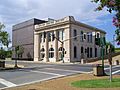
A view of the Alexandria museum in Rapides Parish, Louisiana, USA
-
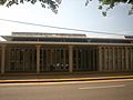
Rapides Parish Library at Alexandria
-
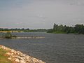
Red River at Alexandria


See also
 In Spanish: Parroquia de Rapides para niños
