River Alport facts for kids
Quick facts for kids Alport |
|
|---|---|

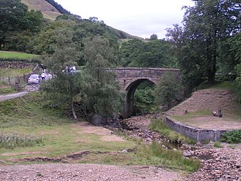
Alport Bridge, which conveys the A57 road over the River Alport just above its confluence with the Ashop
|
|
| Country | England |
| Region | Derbyshire |
| Physical characteristics | |
| Main source | Bleaklow, England |
| River mouth | Derbyshire, England 53°24′09″N 1°47′19″W / 53.402518°N 1.788492°W |
| Length | 9 km (5.6 mi) |
The River Alport is a small but interesting river in the Peak District in Derbyshire, England. It flows for about 9 kilometers (5.6 miles) through a beautiful area known as the Dark Peak.
This river is special because it starts high up on a moorland called Bleaklow. Its water eventually joins other rivers and reservoirs before reaching the North Sea.
Contents
Where the River Alport Flows
The River Alport begins its journey on Bleaklow, which is about 3 miles east of Glossop. From there, it flows south through a boggy area called Grains in the Water.
The river then passes over a type of rock called gritstone. It flows below the Alport Castles landslide, which is a famous natural feature.
Finally, the River Alport reaches Alport Bridge on the A57 Snake Pass route. Here, it joins the River Ashop.
The Journey to the Sea
The River Ashop, which the Alport joins, flows into Ladybower Reservoir. This reservoir is about 2.5 kilometers (1.5 miles) further down the valley.
Water from Ladybower Reservoir then flows into the River Derwent. The Derwent eventually joins the River Trent. Finally, the River Trent carries the water all the way to the North Sea. The source of the Alport is very close to the main watershed of the Pennines.
Water Features and History
As the River Alport flows, it creates three small waterfalls along its course. These add to the natural beauty of the valley.
At the southern end of the river, you can find the remains of a tunnel. This tunnel was built a long time ago to carry water to a cotton mill that was planned but never actually built.
Moving Water for Reservoirs
Around 1922, a weir was constructed on the River Alport. A short water channel was also added. This system was designed to feed water into the Ashop weir, which was located further upstream.
The water was then carried through a culvert (an underground pipe) along the valley. It went to the Ashop Siphon near Hagg Farm. Here, the water crossed over the River Ashop in a large steel pipe, about 6 feet (1.8 meters) wide and 273 yards (250 meters) long.
After crossing the Ashop, the water went through another tunnel, which was about 1065 yards (974 meters) long. Finally, it flowed through an open water channel for about 761 yards (696 meters). This channel discharged the water into the Derwent Reservoir, very close to its dam wall. You can even see the outlet from a viewing area.
The Valley and Its Surroundings
The valley where the River Alport flows has some farmland. However, the sides of the valley are mostly covered with coniferous trees, which are evergreen trees like pines. There are also areas of heathland, which is open land with small shrubs.
The coniferous tree plantations are slowly being changed into semi-natural deciduous woodland. This means more trees that lose their leaves in autumn are being planted.
A small village, or hamlet, called Alport is located on the west bank of the river. It is near the southern end of the river's course.
 | Anna J. Cooper |
 | Mary McLeod Bethune |
 | Lillie Mae Bradford |

