Rockingham, Vermont facts for kids
Quick facts for kids
Rockingham, Vermont
|
|
|---|---|
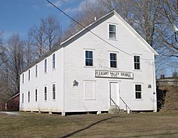
Pleasant Valley Grange Hall, next to the Rockingham Meeting House
|
|
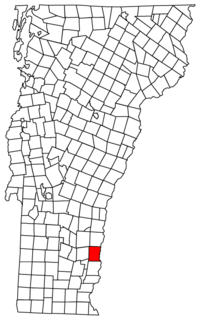
Rockingham, Vermont
|
|
| Country | United States |
| State | Vermont |
| County | Windham |
| Chartered | 1752 |
| Communities |
|
| Area | |
| • Total | 42.3 sq mi (109.6 km2) |
| • Land | 41.9 sq mi (108.5 km2) |
| • Water | 0.4 sq mi (1.1 km2) |
| Elevation | 1,037 ft (316 m) |
| Population
(2020)
|
|
| • Total | 4,832 |
| • Density | 123.1/sq mi (48.7/km2) |
| Time zone | UTC-5 (Eastern (EST)) |
| • Summer (DST) | UTC-4 (EDT) |
| ZIP Codes | |
| Area code(s) | 802 |
| FIPS code | 50-60250 |
| GNIS feature ID | 1462189 |
Rockingham is a town in Windham County, Vermont, United States. It is located along the Connecticut River. In 2020, about 4,832 people lived there.
Rockingham includes the villages of Bellows Falls and Saxtons River. It also has a large countryside area west of Interstate 91.
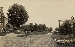
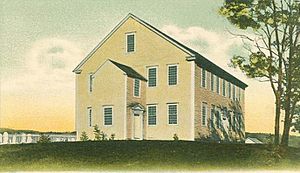
Rockingham does not have one main town center. Instead, the town offices and the public library are in Bellows Falls. The Rockingham Meeting House is considered the approximate center. This Meeting House is on Route 103, a popular road across Vermont. It was built in Rockingham Village, which used to be the main settlement. However, as factories started using water power, people moved to villages near the rivers. Most of Rockingham Village, also called the Old Town, burned in a fire on April 14, 1908. The Meeting House was saved, but many other buildings were not rebuilt.
Contents
History of Rockingham
Rockingham was first given a charter on December 28, 1752. This was part of the New Hampshire grants, which were land grants from the governor of New Hampshire. The town was named after Lord Rockingham. Samuel Johnson and 72 other people were given the land.
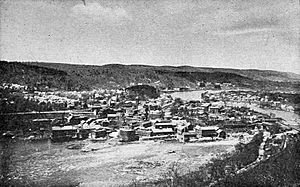
When pioneers first settled here in 1753, the rivers were full of fish like salmon and shad. The native people had fished here for a long time. By 1771, the town had 225 people. In 1785, Colonel Enoch Hale built the first bridge over the Connecticut River. This was the only bridge across the river until 1796. The village of Bellows Falls grew into an important mill town, which meant many factories used the river's power.
Geography of Rockingham
Rockingham covers about 42.3 square miles (109.6 square kilometers). Most of this area is land, with a small part being water. The town has two main rivers, the Williams River and the Saxtons River. Several smaller streams also flow into the Connecticut River, which forms the eastern border of Rockingham.
The highest point in Rockingham is Berry Hill, which is about 1,568 feet (478 meters) high. This hill is near the northwestern part of the town. The lowest point is on the Connecticut River, at the southern border of the town, about 240 feet (73 meters) high.
Major roads that cross Rockingham include Interstate 91, U.S. Route 5, Vermont Route 103, and Vermont Route 121. The Bellows Falls train station used to have service from three different train lines. Today, you can still catch an Amtrak train called the Vermonter here. This train travels south to Washington, D.C., and north to St. Albans, Vermont.
Population and People
The population of Rockingham has changed over time. It was a rural community focused on farming. The number of people living in Rockingham reached its highest point in 1920.
| Historical population | |||
|---|---|---|---|
| Census | Pop. | %± | |
| 1790 | 1,235 | — | |
| 1800 | 1,684 | 36.4% | |
| 1810 | 1,954 | 16.0% | |
| 1820 | 2,155 | 10.3% | |
| 1830 | 2,272 | 5.4% | |
| 1840 | 2,330 | 2.6% | |
| 1850 | 2,837 | 21.8% | |
| 1860 | 2,904 | 2.4% | |
| 1870 | 2,854 | −1.7% | |
| 1880 | 3,797 | 33.0% | |
| 1890 | 4,579 | 20.6% | |
| 1900 | 5,809 | 26.9% | |
| 1910 | 6,207 | 6.9% | |
| 1920 | 6,231 | 0.4% | |
| 1930 | 5,302 | −14.9% | |
| 1940 | 5,737 | 8.2% | |
| 1950 | 5,499 | −4.1% | |
| 1960 | 5,704 | 3.7% | |
| 1970 | 5,501 | −3.6% | |
| 1980 | 5,538 | 0.7% | |
| 1990 | 5,484 | −1.0% | |
| 2000 | 5,309 | −3.2% | |
| 2010 | 5,282 | −0.5% | |
| 2020 | 4,832 | −8.5% | |
| U.S. Decennial Census | |||
In 2000, there were 5,309 people living in Rockingham. Most residents were White. A small number of people were African American, Native American, Asian, or from other backgrounds. Some people identified as Hispanic or Latino.
About 31% of households had children under 18 living with them. Many households were made up of married couples. Some households had a female head without a husband. About 30% of all households were individuals living alone. The average household had about 2.39 people.
The population included people of all ages. About 25% were under 18 years old. About 15% were 65 years or older. The average age in the town was 39 years.
Historic Places in Rockingham
Many places in Rockingham are listed on the National Register of Historic Places. This means they are important historical sites that are protected. Here are some of them:
- Bartonsville Covered Bridge – a bridge over the Williams River
- Worrall Covered Bridge – another bridge over the Williams River
- Hall Covered Bridge – a bridge over the Saxtons River
- Parker Hill Rural Historic District – an area with historic roads
- Rockingham Meeting House – an important historic building
- Rockingham Village Historic District – the historic area of Rockingham Village
- Williams River Route 5 Bridge – a bridge on U.S. Route 5
- Adams Gristmill Warehouse – a warehouse in Bellows Falls
- Bellows Falls Co-operative Creamery Complex – a creamery complex in Bellows Falls
- Bellows Falls Petroglyph Site (VT-WD-8) – a site with ancient rock carvings
- Bellows Falls Times Building – a historic building in Bellows Falls
- Bellows Falls Downtown Historic District – the historic downtown area of Bellows Falls
- Bellows Falls Neighborhood Historic District – a historic neighborhood in Bellows Falls
- Gas Station at Bridge and Island Streets – a historic gas station
- George-Pine-Henry Street Historic District – a historic street area in Bellows Falls
- Vermont Academy Campus Historic District – the historic campus of Vermont Academy in Saxtons River
- Saxtons River Village Historic District – the historic village area of Saxtons River
- Miss Bellows Falls Diner – a historic diner in Bellows Falls
- Moore and Thompson Paper Mill Complex – a paper mill complex in Bellows Falls
- Oak Hill Cemetery Chapel – a chapel in Bellows Falls
- William A. Hall House – a historic house in Bellows Falls
- Howard Hardware Storehouse – a historic storehouse in Bellows Falls
- Robertson Paper Company Complex – a paper company complex in Bellows Falls (this building was taken down between 2018 and 2019)
- Williams Street Extension Historic District – a historic street area in Bellows Falls
- Westminster Terrace Historic District – a historic area in Bellows Falls and Westminster
Other Communities
Besides the larger villages of Bellows Falls and Saxtons River, Rockingham also has smaller communities. These are sometimes called hamlets.
- Bartonsville: This small community had mills built around 1840. It used to be a stop on the Rutland Railroad.
- Brockways Mills: This was a mill site and also a former stop on the Rutland Railroad.
- Cambridgeport: This hamlet has mills and is partly located in the town of Grafton.
Famous People from Rockingham
Many notable people have connections to Rockingham:
- John S. Barry: He was the fourth governor of Michigan.
- Henry Adams Bellows: A lawyer, state lawmaker, and judge.
- Jonathan Blanchard: A pastor, social reformer, and president of Wheaton College.
- Hetty Green: A famous businesswoman and financier.
- Hugh H. Henry: A United States Marshal for Vermont.
- Daniel Kellogg: A United States Attorney and a Justice of the Vermont Supreme Court.
- George Bradley Kellogg: An Adjutant General for the Vermont National Guard and a Lieutenant Colonel in the American Civil War.
- Selim Peabody: An educator.
- Zera Pulsipher: A religious leader.
- Shadrach Roundy: A religious leader.
- Henry Franklin Severens: A judge.
See also
 In Spanish: Rockingham (Vermont) para niños


