Rogers County, Oklahoma facts for kids
Quick facts for kids
Rogers County
|
||
|---|---|---|

|
||
|
||

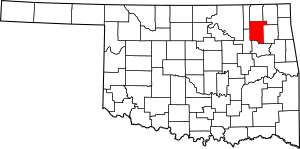
Location within the U.S. state of Oklahoma
|
||
 Oklahoma's location within the U.S. |
||
| Country | ||
| State | ||
| Founded | January 26, 1907 | |
| Named for | Clement Vann Rogers | |
| Seat | Claremore | |
| Largest city | Claremore | |
| Other cities | Catoosa, Collinsville, Owasso, Tulsa | |
| Area | ||
| • Total | 711 sq mi (1,840 km2) | |
| • Land | 676 sq mi (1,750 km2) | |
| • Water | 36 sq mi (90 km2) 5.0%% | |
| Population
(2020)
|
||
| • Total | 95,240 | |
| • Estimate
(2023)
|
100,248 |
|
| • Density | 133.95/sq mi (51.72/km2) | |
| Time zone | UTC−6 (Central) | |
| • Summer (DST) | UTC−5 (CDT) | |
| ZIP Codes |
74015, 74016, 74017, 74018, 74019, 74031, 74036, 74053, 74080
|
|
| Area code | 539, 918 | |
| Congressional districts | 1st, 2nd | |
Rogers County is a county in the northeastern part of Oklahoma, USA. It is known for its beautiful "Green Country" landscape. In 2020, about 95,240 people lived here. This makes it the sixth-largest county in Oklahoma by population.
The main city and county seat is Claremore. Rogers County is also part of the larger Tulsa area.
The county was created in 1907. It was first called Cooweescoowee County. But people wanted to honor Clem Vann Rogers, a famous Cherokee rancher. He was also the father of the well-known entertainer Will Rogers. So, the name was changed to Rogers County.
Contents
History of Rogers County
Long ago, in the 1760s, a group of the Osage Nation called the Arkansas Band lived here. They settled near where the Arkansas, Grand, and Verdigris Rivers meet. They had two villages, Pasuga and Pasona. Pasona was near a large earth mound, now called Claremore Mound. It was named after an Osage chief, Claremore.
Later, in 1828, Cherokee groups moved to this area. They traded their land in Arkansas for this new territory. The United States had received this land from the Osage in 1825. The Cherokee Nation then organized this area as the Saline District. In 1907, a part of this district became the Cooweescoowee District.
When Oklahoma became a state in 1908, this district was named Cooweescoowee County. However, local residents wanted to honor Clement Vann Rogers. He was an early Cherokee settler and a very important rancher in the area. So, the county was renamed Rogers County.
A school called Eastern University Preparatory School was started in Claremore. In 1919, it became the Oklahoma Military Academy. This academy closed in 1971. The buildings were then used for Claremore Junior College. Over time, it grew into a four-year college and then a university. Today, it is known as Rogers State University.
Geography and Nature
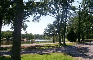
Rogers County covers about 711 square miles. Most of this is land, about 676 square miles. The rest, about 36 square miles, is water. The biggest body of water is Lake Oologah.
The main rivers flowing through the county are the Caney River and the Verdigris River. There are also many smaller creeks and lakes.
Neighboring Counties
Rogers County shares borders with several other counties:
- Nowata County (to the north)
- Craig County (to the northeast)
- Mayes County (to the east)
- Wagoner County (to the south)
- Tulsa County (to the southwest)
- Washington County (to the northwest)
People and Population
| Historical population | |||
|---|---|---|---|
| Census | Pop. | %± | |
| 1910 | 17,736 | — | |
| 1920 | 17,605 | −0.7% | |
| 1930 | 18,956 | 7.7% | |
| 1940 | 21,078 | 11.2% | |
| 1950 | 19,532 | −7.3% | |
| 1960 | 20,614 | 5.5% | |
| 1970 | 28,425 | 37.9% | |
| 1980 | 46,436 | 63.4% | |
| 1990 | 55,170 | 18.8% | |
| 2000 | 70,641 | 28.0% | |
| 2010 | 86,905 | 23.0% | |
| 2020 | 95,240 | 9.6% | |
| 2023 (est.) | 100,248 | 15.4% | |
| U.S. Decennial Census 1790–1960 1900–1990 1990–2000 2010–2019 |
|||
In 2010, there were 86,905 people living in Rogers County. By 2020, the population grew to 95,240. The county is still growing, with an estimated 100,248 people in 2023.
Most people in Rogers County are White. There is also a significant Native American population. Other groups include Black or African American, Asian, and people of two or more races. About 3.7% of the population is Hispanic or Latino.
In 2010, the average age of people in the county was 36 years old. About 28.7% of the population was under 18 years old. Most households were married couples living together.
Cities and Towns
Rogers County has several cities and towns. Some of these are partly in other counties.
Cities
- Catoosa
- Claremore (This is the county seat!)
- Collinsville (mostly in Tulsa County)
- Owasso (mostly in Tulsa County)
- Tulsa (mostly in Tulsa County)
Towns
- Chelsea
- Fair Oaks (mostly in Wagoner County)
- Foyil
- Inola
- Oologah
- Talala
- Valley Park
- Verdigris
Census-Designated Places
These are areas that are like towns but are not officially incorporated as cities or towns.
Unincorporated Communities
These are small communities that are not part of any city or town.
Education in Rogers County
There are many school districts in Rogers County. They serve students from kindergarten through 12th grade (K-12).
K-12 School Districts
- Catoosa Public Schools
- Chelsea Public Schools
- Chouteau-Mazie Public Schools
- Claremore Public Schools
- Collinsville Public Schools
- Foyil Public Schools
- Inola Public Schools
- Oologah-Talala Public Schools
- Owasso Public Schools
- Sequoyah Public Schools
- Verdigris Public Schools
K-8 School Districts
Some districts only serve students from kindergarten through 8th grade (K-8).
- Justus-Tiawah Public Schools
Historic Places
Many places in Rogers County are listed on the National Register of Historic Places (NRHP). These sites are important because they tell us about the history of the area.
Some of these historic sites include:
- I.W.W. Beck Building, Oologah
- The Belvidere, Claremore
- Chelsea Motel, Chelsea
- Claremore Auto Dealership, Claremore
- Eastern University Preparatory School, Claremore
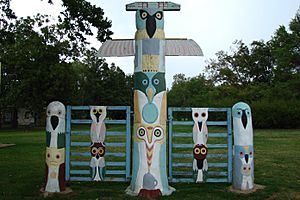
- Ed Galloway's Totem Pole Park, Foyil
- Hanes Home, Sageeyah
- Hogue House, Chelsea
- Mendenhall's Bath House, Claremore
- Maurice Meyer Barracks, Claremore
- Oologah Bank, Oologah
- Oologah Pump, Oologah
- Pryor Creek Bridge, Chelsea
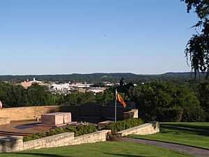
- Will Rogers Birthplace, Oologah
- Will Rogers Hotel, Claremore
- Verdigris Club Lodge, Catoosa
See also
 In Spanish: Condado de Rogers para niños
 | William M. Jackson |
 | Juan E. Gilbert |
 | Neil deGrasse Tyson |


