
Rowley, Massachusetts facts for kids
Quick facts for kids
Rowley, Massachusetts
|
||
|---|---|---|
Rowley, Massachusetts celebrated its 375th anniversary in 2014
|
||
|
||

Location in Essex County and the state of Massachusetts.
|
||
| Country | United States | |
| State | Massachusetts | |
| County | Essex | |
| Settled | 1638 | |
| Incorporated | 1639 | |
| Government | ||
| • Type | Open town meeting | |
| Area | ||
| • Total | 20.3 sq mi (52.7 km2) | |
| • Land | 18.2 sq mi (47.2 km2) | |
| • Water | 2.2 sq mi (5.6 km2) | |
| Elevation | 50 ft (15 m) | |
| Population
(2020)
|
||
| • Total | 6,161 | |
| • Density | 302.79/sq mi (116.91/km2) | |
| Time zone | UTC−5 (Eastern) | |
| • Summer (DST) | UTC−4 (Eastern) | |
| ZIP Code |
01969
|
|
| Area code(s) | 351/978 | |
| FIPS code | 25-58405 | |
| GNIS feature ID | 0618309 | |

Rowley is a town in Essex County, Massachusetts, United States. In 2020, about 6,161 people lived there.
Part of Rowley is also known as the census-designated place of Rowley.
Contents
History of Rowley
In the spring of 1639, Rowley was first settled by Reverend Ezekiel Rogers. He came from England on a ship called the John of London with about twenty families. This ship also brought the first printing press to the American colonies. This press later went to Harvard University.
The town officially became a town on September 4, 1639. It was named after Rowley, a place in England. Reverend Rogers had been a pastor there for twenty years. He was suspended because of his Puritan beliefs.
Early Industries and Buildings
In 1643, a fulling mill was built. This mill helped make cloth. In 1645, a grist mill was built to grind grain. Rowley became known for making cloth from hemp and flax, and also cotton.
In 1642, a special stone arch bridge and a dam were built on the Mill River. This was for the fulling mill. It was the first stone arch bridge in North America. It was made of hand-cut granite and had no mortar. The bridge was rebuilt in the mid-1800s.
A sawmill was started in 1669 and is still working today. In 1868, Moses E. Daniels built a wagon factory. Later, in the early 1900s, Rowley had a busy shoe industry. Boat building was also a successful business.
Historic Homes and the Town Common
Many old colonial homes can be seen on Rowley's streets. They are mixed with other styles from different times in American history. The town common, also called the training place, is surrounded by many old homes.
During the American Revolution, in 1775, Benedict Arnold's group camped at the training place. They were on their way to Quebec.
Education in Rowley
Rowley has one public elementary school called Pine Grove Elementary School. It is located in the town center.
Students in middle school go to Triton Regional Middle School. High school students attend Triton Regional High School. Students from Newbury and Salisbury also go to Triton Regional High School.
Geography of Rowley
Rowley has a total area of about 52.7 square kilometers (20.3 square miles). About 47.1 square kilometers (18.2 square miles) is land, and 5.6 square kilometers (2.2 square miles) is water. This means about 10.56% of the town is water.
Rowley is located along the Atlantic Ocean, north of Cape Ann. A small part of Plum Island and Plum Island Sound separate the mainland from the ocean. Plum Island and some marshes are part of the Parker River National Wildlife Refuge.
Protected Areas and Waterways
The town has other protected areas. These include parts of the Mill Creek Wildlife Management Area and the Georgetown-Rowley State Forest. The Willowdale State Forest and the Arthur Ewell Reservation are also protected. The Bay Circuit Trail also passes through.
Much of the eastern part of the town is marshy. These marshes feed into Mud Creek, Mill River, and the Rowley River. The Rowley River forms part of the town's southern border.
Neighboring Towns and Travel
Rowley is about 7 miles (11 km) south of Newburyport. It is 16 miles (26 km) north of Salem. Lawrence is 17 miles (27 km) to the east, and Boston is 28 miles (45 km) northeast.
Rowley shares borders with several towns:
- To the north: Newbury
- To the northwest: Georgetown
- To the west: Boxford
- To the south: Ipswich
Roads and Public Transport
Interstate 95 goes through the western part of Rowley. The closest exits are in Georgetown and Boxford. U.S. Route 1, also known as the Newburyport Turnpike, passes near the center of town. Massachusetts Route 1A goes through the eastern part of town and the town center.
All three of these roads connect with Massachusetts Route 133. Route 133 goes from west to east through Rowley.
Rowley has a train station on the Newburyport/Rockport Line of the MBTA Commuter Rail. This train service connects Newburyport to the North Shore and Boston's North Station. The closest major airport is Logan International Airport in Boston. A small airport, Plum Island Airport, is in nearby Newburyport.
Population of Rowley
In 2000, there were 5,500 people living in Rowley. There were 1,958 households and 1,468 families. The average household had about 2.77 people.
About 28% of the population was under 18 years old. About 9.4% were 65 years or older. The average age in Rowley was 38 years.
Rowley in Literature
Rowley is mentioned in the short story "The Shadow Over Innsmouth" by H. P. Lovecraft. In the story, the main character escapes to Rowley from a fictional town called Innsmouth. Innsmouth is described as being southeast of Rowley.
Places to Visit
- Agawam Diner
- Chaplin-Clarke House
- Platts-Bradstreet House
Notable People from Rowley
- Jacob Bailey – an author and clergyman.
- Jeremiah Chaplin – the first President of Colby College.
- Parker Cleaveland – a geologist and mineralogist.
- Henry Harriman – an early leader in the Church of Jesus Christ of Latter Day Saints.
- Bruce Kimball – a retired NFL football player. He played for the Washington Redskins and New York Giants.
- Edward Kimball – a Sunday School teacher.
- Eddie MacDonald – a NASCAR driver.
- Jerry Moses – a former catcher for the Boston Red Sox.
- Josiah Little Pickard – an educator.
- Nathaniel Prime – a merchant and banker.
- John S. Tenney – a former Justice of the Maine Supreme Judicial Court.
Images for kids
-
Rowley, Massachusetts celebrated its 375th anniversary in 2014
-
Seal of Rowley, Massachusetts
-
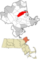
Location in Essex County and the state of Massachusetts.
See also
 In Spanish: Rowley (Massachusetts) para niños
