Rubers Law facts for kids
Quick facts for kids Rubers Law |
|
|---|---|

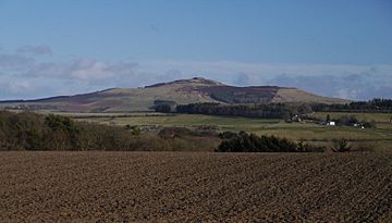
Rubers Law, seen from the edge of Hawick
|
|
| Highest point | |
| Elevation | 424 m (1,391 ft) |
| Prominence | 196 m (643 ft) |
| Parent peak | Peel Fell |
| Listing | Marilyn |
| Geography | |
| Parent range | Cheviot Hills |
| OS grid | NT 58032 15569 |
| Topo map | OS Explorer 331, Landranger 80 |
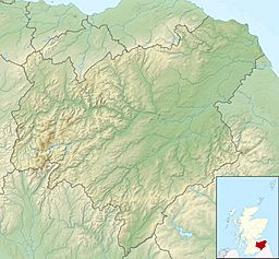
Rubers Law is a tall, cone-shaped hill in the Scottish Borders, Scotland. It sits by the River Teviot, between the towns of Hawick and Jedburgh, and south of Denholm village. The hill used to be on the edge of the old Cavers and Hobkirk areas. Until 1975, it was part of Roxburghshire.
Much of the hill is farmland with conifer tree plantations. There is also rough grazing land near the top. Walkers can choose different paths to reach the rocky summit. From the top, you get amazing views in every direction. The rocks at the summit are what's left of a volcanic vent. This formed when a volcano erupted about 330 million years ago, during the Carboniferous Period.
On and around the summit, you can find the remains of old buildings. These include an Iron Age hill fort, a Roman signal station, and an early medieval "nuclear fort." A famous preacher named Alexander Peden might have given sermons here. He spoke to illegal meetings of Covenanters from a spot called "Peden's Pulpit" among the rocks. The poet Dr John Leyden, who was born in Denholm, climbed the hill when he was young. He wrote about it in a poem in 1803.
Contents
What's in a Name?
The word "Law" is often used for hills in south-east Scotland, especially in Lothian and the Scottish Borders. It comes from an old Anglo-Saxon word, hlāw, which means a mound or hill. No one is quite sure where the first part of the name, "Rubers," comes from or what it means.
How the Hill Looks
Rubers Law is a cone-shaped hill that stretches from north to south. It stands out on its own but is connected to Peel Fell by a high ridge. This makes it a northern part of the Cheviot Hills, which are found on the border between Scotland and England. The hill is on the south side of the River Teviot and is easy to spot from many places in Teviotdale.
Rubers Law rises to 424 meters (1,391 feet) high. Its top is 196 meters (643 feet) higher than the land connecting it to the next hill. This height difference means it's classified as a Marilyn. All the water that runs off the hill flows into the Teviot River. Water from the south and east goes via the Rule Water, and water from the west goes via the Dean Burn.
The very top of the hill is rocky. The summit ridge has cliffs that are about 12 to 15 meters (40 to 50 feet) high, except on the north-east side. Two lower rocky ridges sit next to it, separated by deep gullies. A flat area, called a plateau, stretches around the south and east sides of the summit. About 15 meters (50 feet) lower, a natural terrace goes around the hill from the south and east. A deep crack splits the cliff above the plateau. This spot is known as Peden's Pulpit.
From the summit, you can see far and wide. You can see the Cheviot Hills to the south and east. To the north, you'll spot the Eildon Hills, with the Lammermuir Hills even further away. To the west, you can see Hawick and the hills of Liddesdale and Selkirkshire beyond it.
What the Land is Used For
Most of Rubers Law is used for farming. The land is divided into fields by dry stone walls and fences. There are also areas of conifer trees. The summit is surrounded by rough land where animals graze. People also use the land for pheasant shooting. There's even a campsite on the hill, with private spots in some of the wooded areas.
Paths to the Top
The Borders Abbeys Way walking path crosses the north-east side of the hill. It runs between Denholm and Bedrule. There are no other official footpaths on the hill. However, in Scotland, people have access rights to walk on most land responsibly.
From Denholm, you can start your walk on Dean Road. This road is south of the village post office. It leads to a track up the hill that begins near an electricity station. Another way is to follow the Borders Abbeys Way and then go through Denholmhill Wood. Both paths then continue through or next to a strip of woodland that goes south. From the end of the woods, a well-used path leads to the summit.
From the west, a farm track from Whitriggs Farm takes you part of the way. You then need to cross several fields next to another strip of woodland. From the east, near West Lees or the Billerwell road end, you can follow a track through the trees of West Lees Plantation. Or, you can cross a series of fields south of the woods. These routes will lead you to paths that go to the summit.
How Rubers Law Was Formed
Most of Rubers Law is made of red sandstone and other sediments. These rocks were formed during the late Devonian or early Carboniferous Periods. They came from sand and gravel left behind by ancient rivers.
After these sediments were laid down, volcanoes erupted. These eruptions created basaltic lavas, some of which are now found near Kelso. The rocks at the summit of Rubers Law formed inside a volcanic vent. There's a small area of volcanic agglomerate (bits of rock stuck together). This formed in the vent from an explosive eruption of hot magma. The rest of the summit rocks are microgabbro. This is the remains of a volcanic plug that formed when magma cooled inside the vent. Another microgabbro plug is found among the trees of Denholmhill Wood, about 2 kilometers (1.2 miles) north of the summit.
History of the Hill
Many structures have been built on or around the summit of Rubers Law over time.
Ancient Hill Fort
The earliest structure might have been an Early Iron Age hill fort. This fort had an outer wall that ran around the hilltop. It enclosed an area of about 2.8 hectares (7 acres). There was a clear entrance to the south. No Roman stones were used in this wall. This suggests it was built a long time ago. It's also possible it was a wall for keeping cattle, connected to a later fort built after the Roman period.
Roman Signal Station
A Roman signal station likely stood on the hilltop. Many Roman sandstone blocks have been found on the hill. Many of these stones are decorated with a diamond pattern. This same pattern was found on stones at the Roman site of Castlecary. These findings prove that a Roman building was once on the hilltop. In that high position, it could only have been a signal station. In 1863, a worker digging drains on the south-east side of the hill found a collection of Roman bronze items. This was about 120 meters (400 feet) below the summit. The items included a beautifully decorated handle from a bronze jug, and parts of about a dozen other vessels. These items are now kept at Hawick Museum.
Early Medieval Fort
A post-Roman fort was built on the hill. It had an inner area, or citadel, on the summit. It also had an extra section to the south, which included the southern rock ridge and the plateau. This fort was made of loose boulders. It also used stones from the earlier Roman building. The citadel measured about 72 by 32 meters (235 by 105 feet). The extra section was about 91 meters (300 feet) long. This type of structure is known as a "nuclear fort" from the Early Middle Ages. A hut circle inside the citadel was dug up in 1907. However, only small amounts of charcoal and burnt bones were found.
Peden's Pulpit and the Covenanters
In the 1600s, Alexander Peden may have preached to a group of Covenanters from a deep crack in the cliffs on Rubers Law. This spot is known as Peden's Pulpit. After King Charles II returned to the throne in 1660, he tried to change the Church of Scotland's way of worship. The Covenanters strongly wanted to keep the Kirk's traditional Presbyterian style. Ministers like Peden, who were removed from the Kirk, preached to illegal outdoor meetings of their followers between 1660 and 1688.
On Easter Day in 2000, another outdoor church service was held on the summit of Rubers Law. People from the churches in Bedrule, Denholm, and Minto met there. They wanted to celebrate 2,000 years since the birth of Jesus Christ. They also remembered earlier Christians who had worshipped in that same spot. A metal plate fixed to the summit rocks of the hill records this event. The Bedrule church still holds a service on Rubers Law every Easter Day.
Rubers Law in Poetry
The Scottish romantic poet Dr John Leyden (1775-1811) was born in Denholm. He wrote about climbing Rubers Law in his poem Scenes of Infancy (1803).
He described his youthful climbs: Oft have I wandered, in my vernal years, Where Ruberslaw his misty summit rears, And, as the fleecy surges closed amain, To gain the top have traced that shelving lane, Where every shallow stripe of level green, That, winding, runs the shattered crags between
In another part of his poem, he described a storm on the hill. He also mentioned the eagles, which he called "erne," living there.
Dark Ruberslaw, that lifts his head sublime, Rugged and hoary with the wrecks of time! On his broad misty front the giant wears The horrid furrows of ten thousand years; His aged brows are crowned with curling fern, Where perches, grave and lone, the hooded Erne, Majestic bird! by ancient shepherds stiled The lonely hermit of the russet wild, That loves amid the stormy blast to soar, When through disjointed cliffs the tempests roar, Climbs on strong wing the storm, and, screaming high, Rides the dim rack, that sweeps the darkened sky.


