
Sairecabur facts for kids
Quick facts for kids Sairecabur |
|
|---|---|

Sairecabur and Saciel
|
|
| Highest point | |
| Elevation | 5,971 m (19,590 ft) |
| Prominence | 1,300 m (4,300 ft) |
| Parent peak | Acamarachi |
| Geography | |
| Location | Bolivia-Chile |
| Parent range | Andes |
| Geology | |
| Mountain type | Stratovolcano |
| Climbing | |
| First ascent | Pre-Columbian |
Sairecabur is a large volcano found right on the border between Bolivia and Chile. It is part of the Andes mountain range, specifically a section called the Central Volcanic Zone. Sairecabur itself stands tall at about 5,971 meters (19,590 feet).
Near Sairecabur, you can find other mountains like Curiquinca (5,722 meters), Escalante (5,819 meters), and Cerro Colorado (5,748 meters). These mountains have all had lava flows in the past. Other volcanoes close by include Licancabur, Putana, and Juriques.
Sairecabur has a wide, bowl-shaped area called a caldera, which is about 4.5 kilometers (2.8 miles) across. Before this caldera formed, the volcano might have been as high as 7,000 meters (23,000 feet), making it one of the tallest volcanoes on Earth. Lava has flowed from Sairecabur in more recent times, but there are no records of it erupting in human history.
People have found an ancient Inca holy place on Sairecabur. There are also sulfur mines in the area. More recently, a special telescope called the Receiver Lab Telescope was built on the volcano. It is the highest submillimeter telescope in the world, located at an altitude of 5,525 meters (18,127 feet).
Contents
How Sairecabur Formed
Earth's Moving Plates
The Earth's surface is made of huge pieces called tectonic plates. West of South America, one plate, the Nazca Plate, slides under another, the South America Plate. This process is called subduction. This movement created the Andean Volcanic Belt, a long chain of volcanoes.
The Andean Volcanic Belt has different sections. Sairecabur is in the Central Volcanic Zone (CVZ). This area has many stratovolcanoes, which are cone-shaped volcanoes built up by layers of lava and ash. Many of these volcanoes had big, explosive eruptions that changed their shapes.
Volcanoes in the Andes
Many volcanoes in the CVZ are no longer active. Only a few have erupted in recent history. The crust, or outer layer of the Earth, is very thick under these volcanoes, sometimes up to 70 kilometers (43 miles). This thick crust changes the melted rock, or magma, that comes out.
Some of the world's highest stratovolcanoes are in the CVZ. However, they have not been as active as volcanoes in southern Chile or in countries like Colombia and Ecuador. Much of the CVZ in Chile is a desert, which makes it hard to study these volcanoes.
Sairecabur sits on older rock layers called the Puripicar and Chaxas formations. Some of Sairecabur's lava flows have also covered parts of the Purico formation. There are many faults, or cracks in the Earth's crust, beneath Sairecabur and Licancabur.
Where Sairecabur Is Located

Sairecabur is about 25 kilometers (15.5 miles) from the town of San Pedro de Atacama. It sits right on the border between Bolivia and Chile, in Chile's Antofagasta Region. To the south of Sairecabur, you can find Laguna Verde lake, Licancabur volcano, and the Portezuelo de Chaxas pass. East of the Sairecabur mountains are Mount Nelly and Cerro Laguna Verde.
The border between Bolivia and Chile was set along the Sairecabur mountain chain in a treaty from 1904. Sometimes, maps from the two countries show different names for the mountains, which can be confusing. For example, Escalante is also known as Apagado.
The Sairecabur mountain range acts like a natural wall. It separates the Salar de Atacama salt flat on its western side from several small lakes in Bolivia on its eastern side. Other volcanoes like Licancabur, Juriques, and Tocorpuri are also part of this natural divide. Dry valleys on the eastern side of Sairecabur eventually lead to Laguna Verde. A river called the Rio Purifica starts on Sairecabur's slope and later joins another river to form the San Pedro de Atacama River.
Inside Sairecabur
The Sairecabur range is a 22-kilometer (13.7-mile) long chain of volcanoes. It stretches from Escalante volcano in the north to Sairecabur itself in the south. At least ten of these volcanoes have been active in recent times.
Sairecabur, at 5,971 meters (19,590 feet), is the tallest volcano in this chain. A 4.5-kilometer (2.8-mile) wide caldera is located south of Sairecabur. This caldera formed on an older volcano. Lava flows from Sairecabur have reached up to 2.5 kilometers (1.5 miles) to the northwest.

The caldera has cliffs up to 400 meters (1,300 feet) high. Before the caldera collapsed, the volcano was about 7,000 meters (23,000 feet) tall. This would have made it one of the highest volcanoes in the world. Sairecabur has three main cones, or peaks. Some lava flows are thick and short. Glaciers have also shaped Sairecabur, leaving behind piles of rock called moraines.
Young-looking lava flows stretch out from each of the ten active centers in the range. An older center created a 30-kilometer (18.6-mile) long lava flow that went southwest. Some older lava flows from Sairecabur were later covered by lava from Licancabur.
Cerro Colorado and Curiquinca volcanoes are lined up from west to east. Other volcanoes in the area also form similar lines. This suggests that cracks in the Earth's crust control where these volcanoes appear. Sairecabur is located on these cracks, which are also visible near Laguna Verde.
What Sairecabur Is Made Of
The volcanoes Escalante and Sairecabur first erupted dark rocks called andesites. Later, they also erupted dacites, which are lighter in color. The rocks can be black, brown, or gray. They contain different minerals like amphibole, biotite, and quartz.
Scientists can tell that the melted rock inside Sairecabur was very hot, between 850 and 950 degrees Celsius (1,560 and 1,740 degrees Fahrenheit). This magma formed deep inside the Earth and then changed as it moved up through the crust. The rocks from Sairecabur have special chemical signs that are common for volcanoes in the Central Volcanic Zone.
Sairecabur's History
The Chaxas ignimbrite, a type of rock formed from hot ash and gas, might be linked to the eruption that created Sairecabur's caldera. These rocks spread southwest towards the Salar de Atacama. Scientists have named the younger lava flows "Post-Caldera Lavas I" and "Post-Caldera Lavas II." The first set formed during the Pleistocene Ice Age, and the second set formed in the Holocene, which is our current geological period. A fresh-looking lava flow to the northwest seems to be the most recent.
The caldera formed before the Holocene, and the other cones in the range formed after it. During the ice ages, a long glacier filled a valley west of Sairecabur's main peak. This glacier was about 8 kilometers (5 miles) long and reached down to an elevation of 4,600 meters (15,100 feet). The main Sairecabur peak grew inside this glacial valley.
Sairecabur is the youngest volcano in its chain. Escalante is also young but not as new as Sairecabur. There are no reports of Sairecabur being active today. However, hot springs and gas vents have been found near Laguna Verde, which borders Sairecabur. If Sairecabur were to erupt in the future, it would likely produce lava domes and lava flows.
Weather and Wildlife
The climate at Sairecabur is very dry and clear. Because of this, there are no glaciers or permanent snow on Sairecabur, even though an old map from 1985 showed some ice. The Atacama Altiplano, where Sairecabur is located, is a desert. It gets less than 200 millimeters (8 inches) of rain each year. However, it was wetter during the late Ice Age.
The dry, clear weather, along with the low latitude and high altitude, means the region gets a lot of sunlight. Sairecabur receives about 98% of the maximum possible sunlight. This is partly because the Southern Hemisphere's summer solstice (around December 21) happens close to when Earth is closest to the Sun (around January 3). The area also has very high levels of ultraviolet radiation.
Temperatures at 5,820 meters (19,090 feet) can be very cold, ranging from -8.7 to -16.3 degrees Celsius (16 to 3 degrees Fahrenheit). In winter, surface temperatures can go from -20 to 20 degrees Celsius (-4 to 68 degrees Fahrenheit). There are big differences between daytime and nighttime temperatures. The wind is also quite strong, averaging 5 to 11 meters per second (11 to 25 miles per hour).
Scientists have found about 250 different plant species in the area west of Sairecabur and Licancabur. On the volcano itself, special types of yeast that can live in extreme conditions have been discovered. In 1955, "penitentes," which are tall blades of ice, were seen in many places around Saciel.
Sairecabur's Human History
Ancient Times
Both Sairecabur and Curiquinca have ancient mountain sanctuaries built by the Inca people. Licancabur and Juriques also had such holy sites. Sairecabur was seen as a sacred mountain. Some rocks found at old archaeological sites in the Atacama Desert may have come from Sairecabur.
More Recent History
A sulfur mine is active at Saciel, which is north of Sairecabur. Sulfur mining there, and at Cerro Colorado and Putana in the 1950s, helped the town of San Pedro de Atacama grow. The mined sulfur was transported to the town. In 1955, it was reported that there were about 600,000 tons of ore containing 55–60% sulfur. A 21-kilometer (13-mile) long dirt road leads from the El Tatio highway to Sairecabur.
Since 2003, Sairecabur has been home to the Receiver Lab Telescope. This telescope is 0.8 meters (2.6 feet) wide and studies terahertz radiation, a type of light. It was once thought impossible to study this light from the ground because the atmosphere blocks it. At an altitude of 5,525 meters (18,127 feet), this telescope is the highest submillimeter telescope in the world.
Images for kids
-
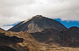
Escalante
-
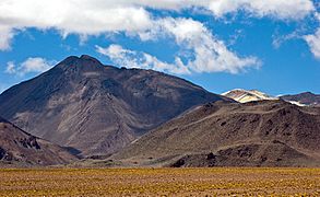
Cerro Colorado
-
Curiquinca
-
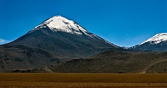
Sairecabur
-
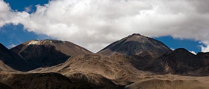
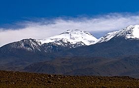
Left Saciel, right Sairecabur
-
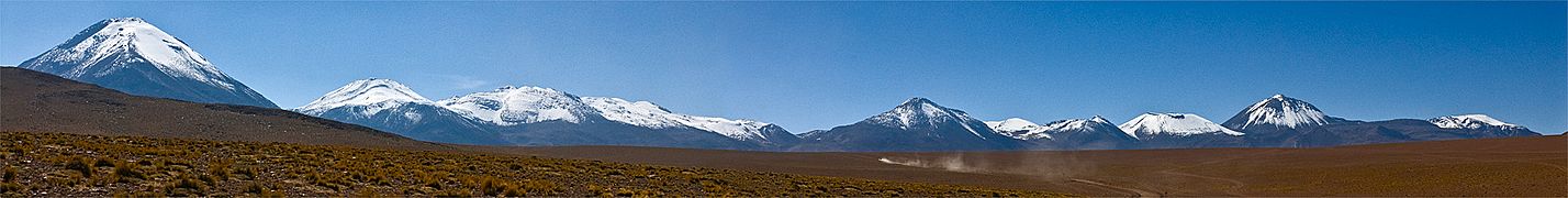
The Sairecabur range. From right to the left, Cerro Colorado, Escalante, Ojos del Toro, Saciel and Sairecabur.
-
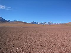
Sairecabur range
-
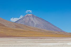
Sairecabur proper


See also
 In Spanish: Sairecabur para niños
