Shaftsbury, Vermont facts for kids
Quick facts for kids
Shaftsbury, Vermont
|
|
|---|---|

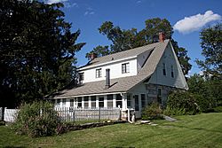
Robert Frost Stone House Museum, home of the poet Robert Frost from 1920 to 1929
|
|

Shaftsbury, Vermont
|
|
| Country | United States |
| State | Vermont |
| County | Bennington |
| Communities | Shaftsbury Shaftsbury Center South Shaftsbury |
| Area | |
| • Total | 43.2 sq mi (111.8 km2) |
| • Land | 43.1 sq mi (111.6 km2) |
| • Water | 0.08 sq mi (0.2 km2) |
| Elevation | 1,043 ft (318 m) |
| Population
(2020)
|
|
| • Total | 3,598 |
| • Density | 83/sq mi (32.2/km2) |
| Time zone | UTC-5 (Eastern (EST)) |
| • Summer (DST) | UTC-4 (EDT) |
| ZIP codes | |
| Area code(s) | 802 |
| FIPS code | 50-63550 |
| GNIS feature ID | 1462203 |
Shaftsbury is a small town located in Bennington County, Vermont, in the United States. In 2020, about 3,598 people lived there. It's a quiet place with a lot of history and natural beauty.
Contents
A Look Back: Shaftsbury's History
Shaftsbury became an official town on August 20, 1761. It was named after a person called the Earl of Shaftesbury.
An important event happened here in June 1843. It was the first time in Vermont that escaped slaves found a safe place to hide on a farm in Shaftsbury. This was part of the Underground Railroad, a secret network that helped people escape slavery to freedom.
Exploring Shaftsbury's Geography
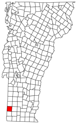
Shaftsbury is in Bennington County, right on the western edge of Vermont. It shares its borders with other towns. To the north, you'll find Arlington. To the east is Glastenbury. The town of Bennington, which is the main town for the county, is to the south. On the west side, Shaftsbury borders two towns in New York: Hoosick and White Creek.
Shaftsbury also includes smaller communities like Shaftsbury Center and South Shaftsbury. A beautiful spot called Lake Shaftsbury State Park is in the northern part of the town, surrounding Lake Shaftsbury.
The town covers a total area of about 111.8 square kilometers (or 43.2 square miles). Most of this area, about 111.6 square kilometers (43.1 square miles), is land. Only a small part, about 0.2 square kilometers (0.1 square miles), is water.
Most of the water in Shaftsbury flows south into the Walloomsac River. However, the northeastern part of town, including Lake Shaftsbury, drains north into the Batten Kill. Both of these rivers eventually flow into the Hudson River.
About the People of Shaftsbury
| Historical population | |||
|---|---|---|---|
| Census | Pop. | %± | |
| 1790 | 1,999 | — | |
| 1800 | 1,895 | −5.2% | |
| 1810 | 1,973 | 4.1% | |
| 1820 | 2,022 | 2.5% | |
| 1830 | 2,143 | 6.0% | |
| 1840 | 1,835 | −14.4% | |
| 1850 | 1,896 | 3.3% | |
| 1860 | 1,936 | 2.1% | |
| 1870 | 2,027 | 4.7% | |
| 1880 | 1,887 | −6.9% | |
| 1890 | 1,652 | −12.5% | |
| 1900 | 1,857 | 12.4% | |
| 1910 | 1,650 | −11.1% | |
| 1920 | 1,534 | −7.0% | |
| 1930 | 1,631 | 6.3% | |
| 1940 | 1,577 | −3.3% | |
| 1950 | 1,673 | 6.1% | |
| 1960 | 1,939 | 15.9% | |
| 1970 | 2,411 | 24.3% | |
| 1980 | 3,001 | 24.5% | |
| 1990 | 3,368 | 12.2% | |
| 2000 | 3,767 | 11.8% | |
| 2010 | 3,590 | −4.7% | |
| 2020 | 3,598 | 0.2% | |
| U.S. Decennial Census | |||
In 2000, there were 3,767 people living in Shaftsbury. The town had 1,450 households, and most of them (about 63%) were married couples living together. About 34.6% of households had children under 18 living with them.
The people in Shaftsbury are of different ages. About 25.8% were under 18 years old, and 13.1% were 65 years or older. The average age in the town was 40 years.
Parks and Outdoor Fun
Lake Shaftsbury State Park is a great place to visit! It's an 84-acre park that surrounds Lake Shaftsbury. It became a state park in 1974. Here, you can enjoy group camping, a nice beach for swimming, a play area, and places to have picnics. It's perfect for outdoor activities and enjoying nature.
Famous People from Shaftsbury
Many interesting people have connections to Shaftsbury:
- Irving Adler – An author, mathematician, scientist, and teacher.
- Joyce Sparer Adler – A literary critic, playwright, and teacher.
- George L. Buck – A businessman and state senator from Wisconsin.
- Robert Frost – A very famous American poet, known for poems like "Stopping By Woods On A Snowy Evening."
- Jonas Galusha – He was the sixth governor of Vermont.
- Jacob M. Howard – A US senator from Michigan.
- Norman Lear – A well-known television writer and producer.
- Andy Newell – A US Nordic skier who competed in the Olympics.
- Gideon Olin – A US congressman from Vermont.
- Henry Olin – Also a US congressman from Vermont, and the sixth Lieutenant Governor of Vermont.
- Jane Stickle – A talented quilter.
See also
 In Spanish: Shaftsbury para niños
 | Toni Morrison |
 | Barack Obama |
 | Martin Luther King Jr. |
 | Ralph Bunche |


