Shark Bay facts for kids
| UNESCO World Heritage Site | |
|---|---|
Shark Bay
|
|
| Location | Gascoyne region, Western Australia, Australia |
| Criteria | Natural: vii, viii, ix, x |
| Inscription | 1991 (15th Session) |
| Area | 2,200,902 ha |
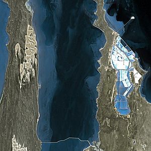
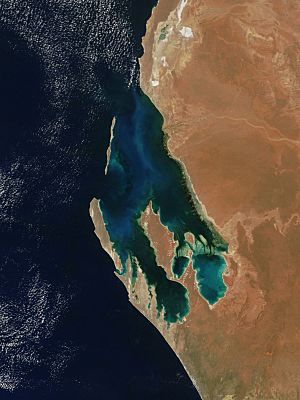
Shark Bay is a special place in Western Australia. It's known as a World Heritage Site, which means it's recognized globally for its unique natural features. The local Aboriginal people, the Malgana, call it Gathaagudu, meaning "two waters".
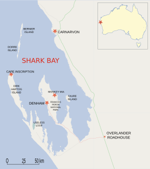
This huge area, about 23,000 square kilometers, is located around 800 kilometers north of Perth. It's the westernmost point of the Australian continent. UNESCO, the organization that lists World Heritage Sites, says Shark Bay has "exceptional natural features." These include one of the biggest and most diverse seagrass beds in the world.
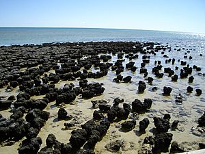
Shark Bay is also famous for its stromatolites. These are dome-shaped structures made by tiny living things, and they are thought to be some of the oldest life forms on Earth! The bay is also home to lots of marine animals, like a large group of dugongs (also called 'sea cows'). It's a safe home for many other animals that are in danger of disappearing from the planet.
This bay has Australia's richest marine ecosystems, which means it has a huge variety of ocean life. It's also a popular spot for fishing.
Contents
History of Shark Bay
People have lived in the Shark Bay area for a very long time. Australian Aboriginal people have been here for at least 22,000 years. Back then, much of the area was dry land. The sea levels rose between 8,000 and 6,000 years ago, flooding the bay. Many ancient sites, like shell middens (piles of shells from old meals), have been found. These show what foods people gathered from the sea and land.
European Explorers Arrive
The first Europeans to visit Shark Bay were led by Dirk Hartog in 1616. This was the second group of Europeans known to have reached Australia. The English explorer William Dampier gave the area the name "Shark Bay" on August 7, 1699. Other explorers, like Nicolas Baudin, also visited later.
Europeans, mostly farmers who raised animals, started settling in Shark Bay in the 1860s and 1870s. Pearling (collecting pearls from oysters) quickly became a big industry from 1870. In the early 1900s, commercial whaling also took place here, with up to 1,000 humpback whales caught each season in the late 1930s.
Today, fewer than 1,000 people live in the World Heritage area. They live in small communities that cover less than 1% of the total area. The coastline of the bay is over 1,500 kilometers long!
Climate in Shark Bay
Shark Bay has a hot desert climate. This means it has very hot and dry summers. The winters are very mild and a bit wetter.
| Climate data for Shark Bay Airport (25º53'S, 113º35'E, 34 m AMSL) (2004-2020 normals and extremes) | |||||||||||||
|---|---|---|---|---|---|---|---|---|---|---|---|---|---|
| Month | Jan | Feb | Mar | Apr | May | Jun | Jul | Aug | Sep | Oct | Nov | Dec | Year |
| Record high °C (°F) | 47.3 (117.1) |
49.8 (121.6) |
47.2 (117.0) |
39.9 (103.8) |
37.0 (98.6) |
30.7 (87.3) |
30.3 (86.5) |
35.6 (96.1) |
36.7 (98.1) |
42.8 (109.0) |
44.8 (112.6) |
46.2 (115.2) |
49.8 (121.6) |
| Mean daily maximum °C (°F) | 34.1 (93.4) |
34.9 (94.8) |
34.2 (93.6) |
31.0 (87.8) |
27.5 (81.5) |
23.8 (74.8) |
22.9 (73.2) |
24.2 (75.6) |
26.1 (79.0) |
28.4 (83.1) |
30.4 (86.7) |
32.5 (90.5) |
29.2 (84.5) |
| Mean daily minimum °C (°F) | 21.6 (70.9) |
22.3 (72.1) |
21.4 (70.5) |
18.3 (64.9) |
14.5 (58.1) |
11.7 (53.1) |
10.6 (51.1) |
11.2 (52.2) |
12.8 (55.0) |
15.4 (59.7) |
17.7 (63.9) |
19.8 (67.6) |
16.4 (61.6) |
| Record low °C (°F) | 16.3 (61.3) |
16.5 (61.7) |
13.8 (56.8) |
10.0 (50.0) |
4.5 (40.1) |
3.7 (38.7) |
2.8 (37.0) |
5.0 (41.0) |
6.2 (43.2) |
7.6 (45.7) |
10.3 (50.5) |
13.2 (55.8) |
2.8 (37.0) |
| Average precipitation mm (inches) | 6.7 (0.26) |
24.5 (0.96) |
16.3 (0.64) |
10.3 (0.41) |
23.1 (0.91) |
42.3 (1.67) |
28.6 (1.13) |
19.3 (0.76) |
8.1 (0.32) |
4.6 (0.18) |
2.1 (0.08) |
7.1 (0.28) |
193 (7.6) |
| Average precipitation days (≥ 1.0 mm) | 0.7 | 1.2 | 0.9 | 1.1 | 2.8 | 4.3 | 4.1 | 3.1 | 2.0 | 1.2 | 0.5 | 0.3 | 22.2 |
| Average relative humidity (%) | 43 | 43 | 38 | 41 | 40 | 42 | 43 | 39 | 40 | 41 | 41 | 41 | 41 |
| Average dew point °C (°F) | 16.7 (62.1) |
17.4 (63.3) |
14.6 (58.3) |
13.1 (55.6) |
10.1 (50.2) |
8.1 (46.6) |
7.7 (45.9) |
6.9 (44.4) |
8.3 (46.9) |
10.4 (50.7) |
12.3 (54.1) |
14.1 (57.4) |
11.6 (53.0) |
| Source: Bureau of Meteorology | |||||||||||||
Exploring the Shark Bay World Heritage Site
Shark Bay was named a World Heritage Site in 1991. It was the first place in Western Australia to get this special status. The site covers about 23,000 square kilometers. About 70% of this area is ocean water.
Protected Areas and Parks
The World Heritage Site includes many protected areas. These help keep the natural environment safe. Some of these areas are:
- Shark Bay Marine Park
- Francois Peron National Park
- Hamelin Pool Marine Nature Reserve
- Zuytdorp Nature Reserve
- Many protected islands
The towns of Denham and Useless Loop are within the site's borders, but they are not part of the protected area itself.
Landforms of the Bay
The bay itself is huge, covering 1.3 million hectares. It's not very deep, with an average depth of about 9 meters. The bay is divided by shallow sandbanks and has many peninsulas (pieces of land almost surrounded by water) and islands. Its coastline stretches over 1,500 kilometers.
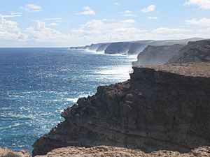
There are about 300 kilometers of limestone cliffs overlooking the bay. One amazing part of these cliffs is called the Zuytdorp Cliffs. The bay is also a meeting point for three different climate zones and two major plant regions.
The Peron Peninsula splits the bay. It's home to the biggest towns and a National Park at its northern tip.
Dirk Hartog Island is important for its history. In 1616, Dirk Hartog landed there and left a special pewter plate to mark his discovery. This plate is now in a museum in the Netherlands, but you can see a copy in Denham.
Bernier and Dorre islands are in the northwest of the heritage area. They are some of the last places where two types of Australian hare-wallabies (small marsupials) still live. These islands are free of introduced animals that might harm the wallabies. This makes them safe places to help bring back species that are in danger on the mainland.
Amazing Animals of Shark Bay
Shark Bay is super important for its animal life. It's home to about 10,000 dugongs, which is about 12.5% of all the dugongs in the world! There are also many Indo-Pacific bottlenose dolphins, especially at Monkey Mia. These dolphins have been very friendly with people since the 1960s.
The area supports 26 different Australian mammal species that are in danger. There are also over 230 types of birds and nearly 150 types of reptiles. It's a key place for fish, crustaceans, and other sea creatures to breed and grow. You can find over 323 fish species here, including many sharks and rays.
Some bottlenose dolphins in Shark Bay are known to use tools. They protect their noses with a sponge while looking for food on the sandy seabed. Humpback and southern right whales use the bay's waters when they migrate. Other whales, like Bryde's whales, come to the bay to feed or rest. The endangered green and loggerhead sea turtles lay their eggs on the bay's sandy beaches. The biggest fish in the world, the whale shark, gathers in the bay during April and May.
Unique Plants of Shark Bay
Shark Bay has the largest known area of seagrass in the world. These seagrass meadows cover over 4,000 square kilometers of the bay. This includes the 1,030 square kilometer Wooramel Seagrass Bank, which is the biggest seagrass bank on Earth. There's even a 200 square kilometer Posidonia australis meadow formed by a single plant, making it the largest plant in the world!
Shark Bay also has the most types of seagrass found in one place. Twelve different species have been discovered here, with up to nine growing together in some spots. Seagrasses are a very important part of the bay's environment. Over thousands of years, sand and shell pieces have built up in the seagrasses, creating huge seagrass beds. This has made the bay shallower. Seagrasses are the base of the food chain in Shark Bay. They provide homes and shelter for many marine animals and attract the large dugong population.
Because Shark Bay has a hot, dry climate, more water evaporates than falls as rain. This makes the seawater in the shallow parts of the bay very salty, or 'hypersaline'. The seagrasses also slow down the flow of tides, which stops the ocean water from making the bay less salty. The water in the bay is 1.5 to 2 times saltier than the ocean water nearby.
Ancient Stromatolites
It's believed that about 1,000 years ago, tiny living things called cyanobacteria (blue-green algae) started building stromatolites in Hamelin Pool. These structures are like living fossils. They are modern examples of some of the earliest signs of life on Earth! Scientists have found fossilized stromatolites that are 3.5 billion years old.
The living stromatolites in Shark Bay were first found in 1956. Before that, they were only known from fossils. Hamelin Pool has the most diverse and abundant living stromatolites in the world. It's thought that some stromatolites might even contain a new type of chlorophyll, which is what plants use to make food from sunlight.
Shark Bay World Heritage Discovery Centre
If you visit Shark Bay, you can go to the Shark Bay World Heritage Discovery Centre in Denham. It has interactive displays and lots of information about the region's amazing features.
Getting to Shark Bay
You can get to Shark Bay by flying into Shark Bay Airport. You can also drive there along the World Heritage Drive, a 150-kilometer road that connects Denham to the North West Coastal Highway.
Special Protected Areas in Shark Bay
National Parks and Reserves
Here are some of the specific national parks and reserves found within the Shark Bay World Heritage Area:
- Bernier Island
- Dorre Island
- Charlie Island
- Francois Peron National Park
- Friday Island
- Hamelin Pool Marine Nature Reserve
- Hamelin Pool/East Faure Island High-Low Water Mark
- Koks Island
- Monkey Mia
- Shark Bay Marine Park
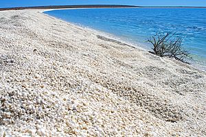
- Shell Beach
- Small Islands
- Zuytdorp Nature Reserve
Bays within the World Heritage Area
- Hamelin Pool
- Henri Freycinet Harbour
- L'Haridon Bight
Islands within the World Heritage Area
- Bernier Island
- Dirk Hartog Island
- Faure Island
Peninsulas within the World Heritage Area
- Bellefin Prong
- Heirisson Prong
- Carrarang Peninsula
- Peron Peninsula
See also
 In Spanish: Bahía Shark para niños
 | Delilah Pierce |
 | Gordon Parks |
 | Augusta Savage |
 | Charles Ethan Porter |


