Skykomish, Washington facts for kids
Quick facts for kids
Skykomish
|
|
|---|---|
 |
|
Location of Skykomish, Washington
|
|
| Country | United States |
| State | Washington |
| County | King |
| Founded | 1889 |
| Incorporated | June 5, 1909 |
| Area | |
| • Total | 0.34 sq mi (0.88 km2) |
| • Land | 0.31 sq mi (0.81 km2) |
| • Water | 0.03 sq mi (0.07 km2) |
| Elevation | 929 ft (283 m) |
| Population
(2020)
|
|
| • Total | 161 |
| • Estimate
(2022)
|
158 |
| • Density | 700.64/sq mi (270.42/km2) |
| Time zone | UTC−8 (Pacific (PST)) |
| • Summer (DST) | UTC−7 (PDT) |
| ZIP code |
98288
|
| Area code(s) | 360 |
| FIPS code | 53-64855 |
| GNIS feature ID | 1525897 |
Skykomish is a small town in King County, Washington, United States. In 2020, about 161 people lived there. This is much fewer than the "several thousand" people who lived there in the 1920s.
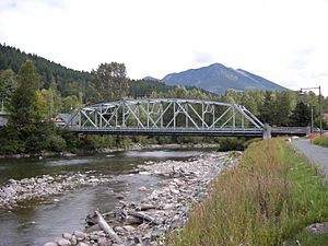
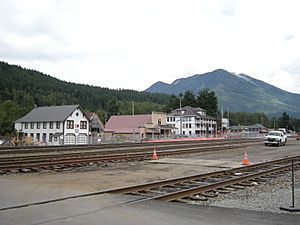
The town is located inside the Mount Baker-Snoqualmie National Forest. It is about 49 miles east of Everett, Washington, along the South Fork of the Skykomish River. Skykomish started as a town for the railroad. Today, it is a popular stop for people who enjoy outdoor activities in the mountains. This includes skiing at nearby Stevens Pass.
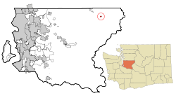
Skykomish is in the far northeastern part of King County. Mountains block direct road access to the rest of the county. Instead, U.S. Highway 2 connects it to Snohomish County to the north. It also connects through Stevens Pass, about 17 miles east, to Chelan County.
Contents
History of Skykomish
How Skykomish Got Its Name
The name "Skykomish" comes from the Skykomish or Skai-whamish tribe. These Native American people lived in the area before settlers from Europe arrived. They were once considered a part of the Snoqualmie tribe.
Early Days and Growth
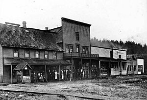
In 1892, John Maloney, a guide for the Great Northern Railway, settled in a flat area. This spot was first called "Maloney's Siding." The railroad was finished the next year, in 1893. When a post office opened, the place became known as Skykomish. The town was officially planned in 1889. It became an official town on June 5, 1909.
John Maloney opened Maloney's General Store in 1893. Soon after, the Skykomish Hotel was built. This hotel burned down in 1902 and was replaced by Schneider's Hotel. In 1904, another fire destroyed almost every business building except Maloney's store. Maloney's General Store is now a historic place, added to the National Register of Historic Places in 1997. In 2000, the entire business area, including the historic Skykomish Hotel (built after Schneider's Hotel burned down), was also added to the Register.
The Railroad's Role
From the 1890s until 1974, Skykomish was an important stop for the Great Northern Railway. This railway later became part of the Burlington Northern Railroad, and now it is the BNSF Railway. At its busiest, eight passenger trains stopped in Skykomish every day. Famous trains like the Great Northern Flyer and the Empire Builder also stopped there.
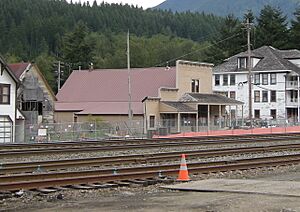
Skykomish was also where electric trains started their journey through the Cascade Tunnel to Wenatchee from 1928 to 1956. Here, steam or diesel locomotives would switch to electric ones. The old Great Northern Depot, which was the Skykomish station, was moved to a new city park in 2012. Today, it is a visitors center and a history museum.
Community Services and Population Changes
The town got a public library service in 1944, run by the King County Rural Library District. The library opened in the city hall the next year. It moved to a new building in 1993, which was made bigger in 2006.
Skykomish's population was highest in the 1920s, with about 8,000 people. By 1990, it had shrunk to under 300. This happened because many businesses and jobs left the town.
Environmental Cleanup Efforts
In the past, some waste disposal methods were not safe. This caused the soil, groundwater, and the Skykomish River to become polluted with oil and heavy metals. Students from the local school made a video about the oil under the town. They won the 2002 President’s Environmental Youth Award for their work.
BNSF (the railroad company) and the Washington State Department of Ecology started talking about cleaning up the area in the 1980s. In 2006, they agreed on a plan. The railroad would pay up to $50 million to clean the area over three years, which was finished in 2009. This cleanup involved huge excavations. Workers removed the polluted soil and replaced it with clean soil. They also rebuilt a levee to protect the town. The total cost of the cleanup ended up being over $100 million.
During the cleanup, 22 buildings in Skykomish, including homes and businesses, were temporarily moved. After the polluted soil was removed, the buildings were put back on new foundations with new utilities. The town also got new sidewalks and street lights. The cleanup helped keep Skykomish's historic look while adding modern features. A big benefit for everyone was a new Waste Water Treatment system connected to every building.
Sports History
In 1954, the Skykomish Basketball team won the State B championship. They beat the much larger Bainbridge team. Skykomish had only 51 students that year, while Bainbridge had 266.
Geography of Skykomish
Skykomish is located at 47°42′36″N 121°21′21″W / 47.71000°N 121.35583°W. It does not have a direct road connection to the rest of King County. Instead, you reach it by U.S. Route 2 through Snohomish County. Because Skykomish is somewhat isolated from the rest of King County, some people have suggested it should join Snohomish County.
The United States Census Bureau says the town covers about 0.33 square miles (0.88 square kilometers). Most of this area, about 0.31 square miles (0.81 square kilometers), is land. The rest, about 0.02 square miles (0.07 square kilometers), is water.
Climate
Skykomish has a climate that is often described as Cfb. This means it has warm, sunny summers and cold, snowy winters.
| Climate data for Skykomish, Washington (1955) | |||||||||||||
|---|---|---|---|---|---|---|---|---|---|---|---|---|---|
| Month | Jan | Feb | Mar | Apr | May | Jun | Jul | Aug | Sep | Oct | Nov | Dec | Year |
| Mean daily maximum °F (°C) | 39.7 (4.3) |
42.4 (5.8) |
49.9 (9.9) |
58.2 (14.6) |
64.9 (18.3) |
69.8 (21.0) |
76.1 (24.5) |
75.2 (24.0) |
70.5 (21.4) |
59.0 (15.0) |
46.8 (8.2) |
40.9 (4.9) |
57.8 (14.3) |
| Mean daily minimum °F (°C) | 27.2 (−2.7) |
27.5 (−2.5) |
31.4 (−0.3) |
38.0 (3.3) |
43.5 (6.4) |
49.0 (9.4) |
49.0 (9.4) |
49.7 (9.8) |
47.0 (8.3) |
40.8 (4.9) |
32.7 (0.4) |
31.3 (−0.4) |
38.9 (3.8) |
| Average precipitation inches (mm) | 12.60 (320) |
12.26 (311) |
9.35 (237) |
6.17 (157) |
5.25 (133) |
3.77 (96) |
1.62 (41) |
2.14 (54) |
3.86 (98) |
8.19 (208) |
11.37 (289) |
15.15 (385) |
91.73 (2,329) |
| Average snowfall inches (cm) | 14.2 (36) |
17.7 (45) |
6.8 (17) |
0.2 (0.51) |
0 (0) |
0 (0) |
0 (0) |
0 (0) |
0 (0) |
0 (0) |
0 (0) |
7.6 (19) |
46.5 (117.51) |
| Average precipitation days (≥ 0.01 in) | 17 | 16 | 15 | 14 | 13 | 10 | 6 | 7 | 9 | 10 | 14 | 18 | 149 |
| Source: Western Regional Climate Center | |||||||||||||
Population of Skykomish
| Historical population | |||
|---|---|---|---|
| Census | Pop. | %± | |
| 1910 | 238 | — | |
| 1920 | 267 | 12.2% | |
| 1930 | 562 | 110.5% | |
| 1940 | 479 | −14.8% | |
| 1950 | 497 | 3.8% | |
| 1960 | 366 | −26.4% | |
| 1970 | 283 | −22.7% | |
| 1980 | 209 | −26.1% | |
| 1990 | 273 | 30.6% | |
| 2000 | 214 | −21.6% | |
| 2010 | 198 | −7.5% | |
| 2020 | 161 | −18.7% | |
| 2022 (est.) | 158 | −20.2% | |
| U.S. Decennial Census | |||
2020 Census Information
According to the 2020 census, 161 people lived in Skykomish. There were 49 households in the town.
2010 Census Information
In the 2010 census, there were 198 people living in Skykomish. There were 95 households and 45 families. The town had about 638.7 people per square mile (246.6 per square kilometer). There were 168 housing units, with about 541.9 units per square mile (209.2 per square kilometer).
Most of the people in town were White (95.5%). There were also small numbers of African American, Native American, and Asian residents. About 1.5% of the population was Hispanic or Latino.
Out of the 95 households, 20% had children under 18. About 34.7% were married couples. About 44.2% of households had only one person living there. About 14.7% had someone aged 65 or older living alone. The average household had 2.08 people, and the average family had 2.87 people.
The average age in Skykomish was 51.3 years. About 18.2% of residents were under 18. About 18.7% were 65 or older. The town had more males (57.1%) than females (42.9%).
Infrastructure and Internet Access
For a long time, people in Skykomish mostly used dial-up for internet. This was much later than other parts of King County. In the 2010s, DSL internet became widely available. In 2021, a project was announced to bring fiber-optic internet to Skykomish. This $1.3 million project is funded by the state government and carried out by Ziply Fiber. Even though an existing fiber-optic cable runs underground through parts of the town, it did not serve the residents before this project.
See also
 In Spanish: Skykomish (Washington) para niños
 | James Van Der Zee |
 | Alma Thomas |
 | Ellis Wilson |
 | Margaret Taylor-Burroughs |


