
The Solent facts for kids
Quick facts for kids
Designations
|
|
| Official name: Solent and Southampton Water | |
| Designated: | 1 October 1998 |
|---|---|
| Reference #: | 965 |


The Solent (pronounced SOH-lənt) is a narrow stretch of water, like a river, that lies between the Isle of Wight and the mainland of Great Britain. It is about 20 miles (32 km) long. Its width changes, from about 2.5 miles (4 km) to 5 miles (8 km). However, at one point, a narrow strip of land called the Hurst Spit makes the crossing only a bit over 1 mile (1.6 km) wide.
The Solent is a very busy waterway. Many ships use it for passengers, goods, and military purposes. It's also a popular place for water sports, especially yachting. A famous sailing event called Cowes Week happens here every year. The Isle of Wight protects the Solent from big waves. It also has a special tidal pattern, which helps Southampton's port. This "double high tide" means big ships can use the port for longer periods. The city of Portsmouth is also located on its shores. Spithead, an area near Gosport, is where the Royal Navy traditionally shows off its ships to the monarch.
This area is very important for nature and its beautiful scenery. Its coastlines and river mouths are special habitats. Much of the coastline is a protected area called a Special Area of Conservation. The Solent is also part of important landscapes like the New Forest National Park and the Isle of Wight AONB.
Contents
What's in a Name?
The name "Solent" is very old, even older than Old English. It was first written down in the year 731 as Soluente. This old spelling might come from a very early British word, -uente. This word is also found in other local names, like the Roman city of Venta Belgarum (now Winchester).
Later, the Anglo-Saxons called it Solentan.
Some people think the name might come from an even older word, possibly from Semitic languages, meaning "free-standing rock." This could describe the cliffs at the western entrance. This idea suggests that Phoenician traders, who sailed to Britain for tin long ago, might have used this word.
Another idea is that the name comes from the Northern Gannet bird. These birds were once called "Solans" or "Solan Goose" and were common along the coast.
How the Solent Was Formed
The Solent was not always a body of water. Long, long ago, it was a river valley. Over thousands of years, it slowly became wider and deeper. The River Frome was the main river, and other rivers like the Avon, Hamble, Itchen, and Test flowed into it.
Scientists have found that when sea levels were much lower, the Solent River carved its bed very deep, more than 150 feet (46 meters) below where the sea is now.
About 10,000 years ago, at the end of the last Ice Age, huge glaciers in the north began to melt. This caused two big changes:
- First, a lot of meltwater flowed into the Solent River, making its valley even deeper.
- Second, as the heavy ice melted in Scotland, the land there rose. This made Great Britain tilt, causing the south of England to slowly sink. This sinking is still happening today.
Over thousands of years, the land in the south continued to sink. This caused many river valleys to become flooded, creating places like Southampton Water and Poole Harbour. The Solent River estuary was slowly covered by water. Eventually, the Isle of Wight became separated from the mainland. This happened when the chalk ridge that connected The Needles on the island to Old Harry Rocks on the mainland wore away. This is thought to have happened about 7,500 years ago.
The coast of the Solent is still changing. Some soft cliffs, like at Fort Victoria, are slowly eroding away. Other areas, like Ryde Sands, are growing as sand builds up.
Unique Tides and Safety
The Solent is a fairly shallow area with strong tides. It has a very unusual "double tide." This means it has two high tides and two low tides each day, which can be both helpful and tricky for boats. The strong currents and quick changes in sea conditions make navigation challenging.
Because so many boats use the Solent, it has many lifeboat stations. There are six RNLI stations (like at Calshot and Cowes) and five independent stations (like Hamble Lifeboat). These stations help keep everyone safe on the water.
A Look Back in Time
People have lived around the Solent for a very long time. Evidence of human homes has been found from prehistoric times, the Roman era, and the Saxon period. This shows that people moved to higher ground as the sea level rose over these periods. Divers have even found the remains of a wooden building underwater near Bouldnor, Isle of Wight. It was built on land around 6000 BC, when the sea was much lower.
There are old stories that much of Hayling Island was lost to the sea. Divers have found the remains of a stone building, probably a church, underwater south of Hayling Island. If so much land was lost, the Solent might have been much narrower in Roman times. Some old reports even say people could wade to the Isle of Wight at low tide!

In the early 1500s, King Henry VIII of England built many forts along the Solent. These forts, called Device Forts, helped control who could enter and leave the area. In 1545, a naval battle was fought here between English and French ships. The battle was a draw, but Henry VIII's famous ship, the Mary Rose, sank. Out of over 400 crew members, fewer than 35 survived. The Mary Rose was found at the bottom of the Solent in 1971 and brought to the surface in 1982.
More forts were built in the 1800s, both on land and in the sea. These were known as Palmerston Forts.
The Solent was also a location for the sailing events during the 1908 Summer Olympics. In April 1912, the famous ocean liner Titanic began its journey from the Solent.
There's a sandbank in the middle of the Solent called Bramble Bank. It appears above the water during the lowest tides of the year. People even play cricket on it once a year during this time, though the game often ends quickly as the tide comes in!
The Solent is also the only place in Western Europe with a regular passenger hovercraft service. Hovercraft can travel right up onto the beach, which is a big advantage with the Solent's changing tides. The company, Hovertravel, has been operating for over 50 years!
Images for kids
-
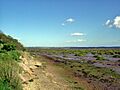
Salt marsh near Lepe Country Park, with the Isle of Wight in the distance.
-
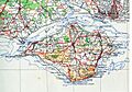
A map of the Solent and surrounding areas from 1945.


See also
 In Spanish: Solent para niños
