
Springville, Utah facts for kids
Quick facts for kids
Springville
|
||
|---|---|---|

Main Street with the snowy Wasatch Mountains in the background
|
||
|
||
| Nickname(s):
Art City
|
||

Location in Utah County and the state of Utah
|
||
| Country | United States | |
| State | Utah | |
| County | Utah | |
| Settled | September 18, 1850 | |
| Incorporated | April 4, 1853 | |
| Named for | a local spring | |
| Area | ||
| • Total | 14.39 sq mi (37.28 km2) | |
| • Land | 14.34 sq mi (37.15 km2) | |
| • Water | 0.05 sq mi (0.13 km2) | |
| Elevation | 4,554 ft (1,388 m) | |
| Population
(2020)
|
||
| • Total | 35,268 | |
| • Density | 2,459.41/sq mi (949.34/km2) | |
| Time zone | UTC−7 (Mountain (MST)) | |
| • Summer (DST) | UTC−6 (MDT) | |
| ZIP code |
84663
|
|
| Area code(s) | 385, 801 | |
| FIPS code | 49-72280 | |
| GNIS feature ID | 2411963 | |

Springville is a city in Utah County, Utah, United States. It is part of the Provo–Orem metropolitan area. In 2020, the city had a population of 35,268 people.
Springville is sometimes called "Art City" because it has a strong focus on the arts. Many people who live in Springville travel to work in nearby cities like Provo, Orem, and Salt Lake City. Other cities close to Springville include Spanish Fork and Mapleton.
Contents
Discovering Springville's Past
The first European explorer to visit the area that is now Springville was Father Silvestre Vélez de Escalante. He was a Franciscan padre (a type of priest) who explored the region in 1776.
Later, the area became part of the Mormon Road. This was a wagon route used by Mormon pioneers and gold seekers. They traveled through Utah, Arizona, Nevada, and California. From 1855 to the late 1860s, freight wagons used this road to carry goods between Los Angeles and Salt Lake City.
How Springville Was Settled
In 1849, a group of pioneers led by William Miller and James Mendenhall explored the area. They loved the Hobble Creek area. Springville was settled in 1850 by eight pioneer families. They were led by Aaron Johnson. These families traveled from the eastern United States to the Salt Lake Valley. Brigham Young, a leader of the pioneers, told them to settle about 50 miles (80 km) further south.
From Hobble Creek to Springville
The city was officially formed in February 1853. The pioneers first named it Hobble Creek. This name came from an early exploration team in 1849. A horse on that team lost its iron hobbles (restraints tied to its front legs) while camped by the creek.
As the town grew, its name changed to Springville. This new name came from Fort Springville. The fort was named for the many freshwater springs in the area. Even though the city's name changed, the original name lives on. The canyon stream, a local elementary school, and a city golf course are still called Hobble Creek.

Springville: The Art City
Springville is known as "Art City" because it has a strong focus on the arts. It is home to the Springville Museum of Art. This is Utah's oldest museum for visual fine arts, opening around 1937.
The museum is in a beautiful Spanish Colonial Revival-style building. It shows art from many famous local and national artists. Its collections include Utah art, a large collection of Soviet art, early American art, and the European Steed collection. The museum was called a "sanctuary of beauty and a temple of meditation."
Springville is also the birthplace of the famous sculptor Cyrus Dallin. The main street of the city has many bronze statues. Some of these were made by local sculptors like Gary Price and Jeff Decker.
Springville's Location and Size
Springville is located on the west side of the Wasatch Mountain Range. It is about 3 miles (4.8 km) east of Utah Lake. Most of the city is east of Interstate 15.
The city covers an area of about 14.39 square miles (37.28 square kilometers). Most of this area is land, with a small part being water.

Who Lives in Springville?
| Historical population | |||
|---|---|---|---|
| Census | Pop. | %± | |
| 1860 | 1,357 | — | |
| 1870 | 1,661 | 22.4% | |
| 1880 | 2,312 | 39.2% | |
| 1890 | 2,849 | 23.2% | |
| 1900 | 4,322 | 51.7% | |
| 1910 | 3,356 | −22.4% | |
| 1920 | 3,010 | −10.3% | |
| 1930 | 3,748 | 24.5% | |
| 1940 | 4,796 | 28.0% | |
| 1950 | 6,475 | 35.0% | |
| 1960 | 7,913 | 22.2% | |
| 1970 | 8,790 | 11.1% | |
| 1980 | 12,101 | 37.7% | |
| 1990 | 13,950 | 15.3% | |
| 2000 | 20,424 | 46.4% | |
| 2010 | 29,466 | 44.3% | |
| 2020 | 35,268 | 19.7% | |
| U.S. Decennial Census | |||
In 2000, there were 20,424 people living in Springville. By 2010, the population had grown to 29,466. In 2020, it increased again to 35,268 people.
Most people in Springville are White. About 4.77% of the population is Hispanic or Latino.
Many households in Springville have children under 18 living at home. The average household has about 3.41 people. The average family has about 3.76 people.
The median age in the city is 25 years old. This means half the people are younger than 25 and half are older. A large number of people aged 18 to 24 live in Springville. This is because students and graduates from Brigham Young University in Provo and Utah Valley University in Orem are moving to the city.
Businesses in Springville
Springville is home to several important businesses and employers. These companies provide many jobs for the people living in the city.
Some of the major businesses include:
- digEcor, Inc: This company makes portable entertainment devices for airplanes.
- Flowserve: This company makes large valves. It has a factory in Springville's Industrial Park.
- Modere: This company moved its main office to Springville in 2003.
- Stouffer's: This is a division of Nestle. It also has a factory in Springville's Industrial Park.
- Wing Enterprises: This company makes the Little Giant Ladder Systems. Its main office is in Springville.
- W.W. Clyde Company: This is a company that does heavy construction work.
- Namify: This company specializes in making name tags and offering other printing services.
- Tatton Baird: This company makes custom hats and accessories.
Fun Events in Springville
Springville hosts several exciting events throughout the year. These events bring the community together and attract visitors.
Art City Days
Art City Days happens every year in early June. It is one of the first city celebrations of the summer in Utah Valley. Residents enjoy many activities to celebrate their community and its history. The event includes a parade, a carnival, hot air balloons, contests, sports, and fireworks.
Springville World Folkfest
The Springville World Folkfest is a week-long celebration of folk dance and music. It takes place every July at the outdoor amphitheater in Spring Acres Arts Park. Folk dance groups from all over the world come to perform at this festival. Local families in Springville host the performers in their homes.
Indian Festival of Utah
Every May, Springville hosts the annual Indian Festival of Utah. This event is also held at Spring Acres Arts Park. It is the only cultural event in Utah focused on the East Indian, Pakistani, and South Asian communities. It celebrates the small but growing Indian American and South Asian American communities in northern Utah.
Springville Public Library
As Springville grew quickly, there was a need for a new library. The old library, the Springville Carnegie Library, was not big enough for the fast-growing city. From 1965 to 2008, the library was in the north wing of the Springville Office Building. The old Carnegie building now houses the Daughters of Utah Pioneers Museum and the Springville Historical Society.
Construction on the current library began in 2008 and finished in 2011. The new library has over one million books, movies, and audiobooks. It also hosts many events, classes, and programs for children.

Schools in Springville
Springville is part of the Nebo School District. The public schools in Springville include:
- Springville High School
- Springville Junior High School
- Spring Canyon Middle School
- Art City Elementary
- Brookside Elementary
- Cherry Creek Elementary
- Sage Creek Elementary
- Meadow Brook Elementary
- Westside Elementary
There are also two charter schools in Springville: Reagan Academy and Merit Academy.
The Elizabeth DeLong School of the Springville Campus of the Utah Schools for the Deaf and the Blind is also in Springville. Construction for this school started in March 2019 and was completed in January 2020.
Springville's Climate
Springville has a climate that can be described as either humid subtropical or humid continental. This means it has warm, humid summers and cold winters.
| Climate data for Springville, Utah | |||||||||||||
|---|---|---|---|---|---|---|---|---|---|---|---|---|---|
| Month | Jan | Feb | Mar | Apr | May | Jun | Jul | Aug | Sep | Oct | Nov | Dec | Year |
| Mean daily maximum °F (°C) | 40 (4) |
46 (8) |
57 (14) |
65 (18) |
75 (24) |
85 (29) |
94 (34) |
92 (33) |
82 (28) |
67 (19) |
52 (11) |
40 (4) |
66 (19) |
| Mean daily minimum °F (°C) | 22 (−6) |
26 (−3) |
33 (1) |
39 (4) |
47 (8) |
54 (12) |
61 (16) |
60 (16) |
51 (11) |
40 (4) |
31 (−1) |
24 (−4) |
41 (5) |
| Average precipitation inches (mm) | 1.9 (48) |
1.9 (48) |
1.9 (48) |
2.0 (51) |
2.1 (53) |
1.2 (30) |
0.8 (20) |
1.0 (25) |
1.4 (36) |
2.0 (51) |
1.7 (43) |
1.9 (48) |
19.8 (501) |
| Source: weather.com | |||||||||||||
Images for kids
-
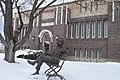
This building was the Springville public library from 1922 to 1965. Now, a sculpture of Mark Twain reading a book is on the lawn.
-
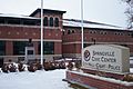
The Springville Civic Center building with the Dallin Pioneer Mother Memorial.
-
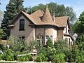
This is the Dallin House, connected to sculptor Cyrus E. Dallin, built around 1905.
-
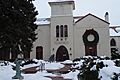
The Art Museum is located on 400 South.
-
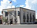
The Central Bank on South Main Street.
-
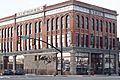
This old building is at the corner of 200 South and Main Street.
-
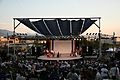
Springville, Utah's World Folkfest.


Famous People from Springville
Many notable people have connections to Springville, including:
- Charity Anderson (born 2000), a dancer
- Quinn Allman (born 1982), lead guitarist for the band The Used
- Don Bluth (born 1937), a film director and animator
- Jeff Decker (born 1966), a sculptor
- Claybourne Elder (born 1982), an actor
- Elfie Caroline Huntington (1868 – 1949), a photographer
- Bryan Johnson (born 1977), an entrepreneur
- Scott Mitchell (born 1968), a former NFL player
- Gary Lee Price (born 1955), a sculptor
- Colby Ward (born 1964), a former pitcher for the Cleveland Indians
See also
 In Spanish: Springville (Utah) para niños
