Steele County, Minnesota facts for kids
Quick facts for kids
Steele County
|
|
|---|---|

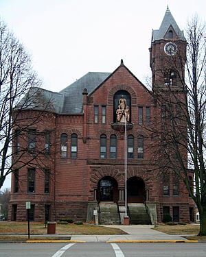
Steele County Courthouse in Owatonna
|
|

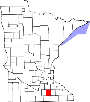
Location within the U.S. state of Minnesota
|
|
 Minnesota's location within the U.S. |
|
| Country | |
| State | |
| Founded | February 20, 1855 |
| Named for | Franklin Steele |
| Seat | Owatonna |
| Largest city | Owatonna |
| Area | |
| • Total | 432 sq mi (1,120 km2) |
| • Land | 430 sq mi (1,100 km2) |
| • Water | 2.7 sq mi (7 km2) 0.6%% |
| Population
(2020)
|
|
| • Total | 37,406 |
| • Estimate
(2023)
|
37,421 |
| • Density | 87.0/sq mi (33.6/km2) |
| Time zone | UTC−6 (Central) |
| • Summer (DST) | UTC−5 (CDT) |
| Congressional district | 1st |
Steele County is a county in the state of Minnesota, USA. In 2020, about 37,406 people lived here. The main city and county seat is Owatonna.
Steele County is part of the Owatonna area, which is a "micropolitan statistical area." This means it's a smaller city area with close ties to nearby communities.
Contents
History of Steele County
The county was created on February 20, 1855. It was formed by the Minnesota Territory government. Parts of Rice, Blue Earth, and Le Sueur counties were used to make Steele County.
The city of Owatonna was chosen as the county seat. People started settling in Owatonna in 1854. The county was named after Franklin Steele. He was an important early resident of the Minnesota Territory.
Geography and Rivers
Steele County has low, rolling hills. Most of the land is used for farming. The land slopes down towards the east and north. The highest point is about 1,293 feet (394 meters) above sea level.
The county covers about 432 square miles (1,119 square kilometers). Most of this is land, with only a small part being water.
Rivers and Waterways
The Straight River starts in Freeborn County. It flows north through the middle of Steele County. It then continues into Rice County.
The South Branch of the Middle Fork of the Zumbro River also starts in Steele County. It flows east into Dodge County. The Le Sueur River flows through the southwest part of the county.
How to Get Around: Transit
- Southern Minnesota Area Rural Transit is a public transportation service.
Major Roads and Highways
Several important roads run through Steele County:
 Interstate 35 runs north and south. It passes through Medford, Clinton Falls, Owatonna, Hope, and Ellendale.
 U.S. Route 14 runs east and west. It passes through Owatonna.
 U.S. Route 218 runs from the southeast to an intersection with US 14.
 Minnesota State Highway 30 runs east and west across the southern part of the county. It passes through Ellendale.
Airports in Steele County
- Owatonna Degner Regional Airport (OWA) is located northwest of Owatonna.
Neighboring Counties
Steele County shares borders with these counties:
- Rice – to the north
- Dodge – to the east
- Mower – to the southeast
- Freeborn – to the south
- Waseca – to the west
Protected Natural Areas
These areas help protect nature in Steele County:
- Aurora State Wildlife Management Area
- Oak Glen State Wildlife Management Area
- Rice Lake State Park
- Somerset State Wildlife Management Area
- Swan Lake State Wildlife Management Area
Lakes in Steele County
Here are some of the lakes you can find in the county:
- Beaver
- Fosilen
- Kohlmeier
- Lonergan
- Oak Glen
- Rice (part)
- Rickert
- Swan
People of Steele County: Demographics
| Historical population | |||
|---|---|---|---|
| Census | Pop. | %± | |
| 1860 | 2,863 | — | |
| 1870 | 8,271 | 188.9% | |
| 1880 | 12,400 | 49.9% | |
| 1890 | 13,232 | 6.7% | |
| 1900 | 16,524 | 24.9% | |
| 1910 | 16,146 | −2.3% | |
| 1920 | 18,061 | 11.9% | |
| 1930 | 18,475 | 2.3% | |
| 1940 | 19,749 | 6.9% | |
| 1950 | 21,155 | 7.1% | |
| 1960 | 25,029 | 18.3% | |
| 1970 | 26,931 | 7.6% | |
| 1980 | 30,328 | 12.6% | |
| 1990 | 30,729 | 1.3% | |
| 2000 | 33,680 | 9.6% | |
| 2010 | 36,576 | 8.6% | |
| 2020 | 37,406 | 2.3% | |
| 2023 (est.) | 37,421 | 2.3% | |
| U.S. Decennial Census 1790-1960 1900-1990 1990-2000 2010-2020 |
|||
The table above shows how the population of Steele County has grown over many years.
2020 Census Information
In 2020, the United States Census collected information about the people living in Steele County. Here's a look at the different groups:
| Race | Number of People | Percentage |
|---|---|---|
| White (Non-Hispanic) | 31,376 | 83.9% |
| Black or African American (Non-Hispanic) | 1,359 | 3.63% |
| Native American (Non-Hispanic) | 65 | 0.2% |
| Asian (Non-Hispanic) | 330 | 0.9% |
| Pacific Islander (Non-Hispanic) | 18 | 0.05% |
| Other/Mixed (Non-Hispanic) | 1,118 | 3% |
| Hispanic or Latino | 3,140 | 8.4% |
This table shows that most people in Steele County are White. There are also many people of Hispanic or Latino background, and other groups too.
Cities and Towns
Steele County has several communities, including cities and smaller towns.
Cities in Steele County
- Blooming Prairie (partly in Dodge County)
- Ellendale
- Medford
- Owatonna (This is the county seat, where the main county government offices are.)
Unincorporated Communities
These are smaller communities that are not officially cities or towns:
- Bixby
- Clinton Falls
- Deerfield
- Havana
- Hope
- Lemond
- Litomysl
- Meriden
- Merton
- Moland
- Pratt
- Saco
- Steele Center
Ghost Town
- Rice Lake is a former community that is no longer inhabited.
Townships
Townships are local government areas, usually rural:
- Aurora
- Berlin
- Blooming Prairie
- Clinton Falls
- Deerfield
- Havana
- Lemond
- Medford
- Meriden
- Merton
- Owatonna
- Somerset
- Summit
See also
 In Spanish: Condado de Steele (Minnesota) para niños
 | Misty Copeland |
 | Raven Wilkinson |
 | Debra Austin |
 | Aesha Ash |

