
Street Mountain (New York) facts for kids
Quick facts for kids Street Mountain |
|
|---|---|
_Peak.jpg)
The trail sign at Street Mountain's peak.
|
|
| Highest point | |
| Elevation | 1,265 metres (4,150 ft) |
| Prominence | 390 m (1,280 ft) |
| Listing | Adirondack High Peaks 31st |
| Geography | |

Street Mountain
Location in New York Adirondack Park

Street Mountain
Location in the United States
|
|
| Location | North Elba, Essex County, New York |
| Parent range | Street Range |
| Topo map | USGS Ampersand Lake |
Street Mountain is a tall mountain found in Essex County, New York. It was named after Alfred Billings Street (1811–1881), who was a poet and a librarian for New York State. This mountain is the highest point in the Street Range, which is part of the famous Adirondack Mountains. Just northeast of Street Mountain is another peak called Nye Mountain.
Street Mountain is located within the High Peaks Wilderness Area. This area is a special part of New York's Adirondack Park, protected for its wild nature.
Contents
Where Does the Water Go?
Street Mountain is important for water flow. All the water that runs off its slopes eventually reaches the Saint Lawrence River. This large river then flows into the Gulf of Saint Lawrence in Canada.
Water Flowing East
Water from the southeast, east, and northeast sides of Street Mountain flows into a stream called Indian Pass Brook. This brook then joins the West Branch of the Ausable River. From there, the water travels to Lake Champlain, then into Canada's Richelieu River, and finally into the Saint Lawrence River.
Water Flowing West
The north and northwest slopes of Street Mountain send their water into the start of the Chubb River. This river also flows into the Ausable's West Branch. The far west side of Street Mountain drains into Moose Creek, which leads to the Cold River. The Cold River then joins the Raquette River, which also flows into the Saint Lawrence River in Canada. Even the southwest slopes of Street Mountain contribute water to Roaring Brook, which feeds into Duck Hole pond, the beginning of the Cold River.
Hiking Street Mountain
Climbing Street Mountain can be a fun adventure, but it's important to be prepared. The trail to the top is not marked with signs. This means it can be tricky to follow, especially if there's snow covering the path.
Trail Challenges
One part of the trail requires hikers to cross a stream. If it has been raining a lot, or during the spring snowmelt, this stream can become too wide or fast to cross safely. Because of these challenges, it's a good idea for hikers to bring a map and a compass to help them find their way.
Images for kids
-
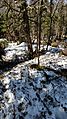
Snow conditions descending Street Mountain on a warm May day.

