
Sussex County, Virginia facts for kids
Quick facts for kids
Sussex County
|
|
|---|---|
,_Sussex,_Virginia.jpg)
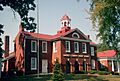
Sussex County Courthouse
|
|

Location within the U.S. state of Virginia
|
|
 Virginia's location within the U.S. |
|
| Country | |
| State | |
| Founded | 1754 |
| Named for | Sussex, England |
| Seat | Sussex |
| Largest town | Waverly |
| Area | |
| • Total | 493 sq mi (1,280 km2) |
| • Land | 490 sq mi (1,300 km2) |
| • Water | 2.6 sq mi (7 km2) 0.5% |
| Population
(2020)
|
|
| • Total | 10,829 |
| • Density | 21.966/sq mi (8.481/km2) |
| Time zone | UTC−5 (Eastern) |
| • Summer (DST) | UTC−4 (EDT) |
| Congressional district | 4th |
Sussex County is a rural area in the southeast part of Virginia. It is called a "county" and is part of the state of Virginia. In 2020, about 10,829 people lived here.
The main town and government center is Sussex. The county was created in 1754 from Surry County. It was named after Sussex, a county in England. Sussex County is also part of the larger Greater Richmond Region.
Contents
A Look at Sussex County's Past
Long, long ago, maybe even 10,000 years ago, Native Americans lived near the Nottoway River in what is now Sussex County. One important group was the Nottoway people. Even though they spoke a different language, they were loosely connected to the Powhatan Confederacy. This was a large group of Native American tribes.
When English colonists arrived in Virginia in 1607, some explored the Nottoway River area. The first counties were set up, and this land became part of James City County. Later, in 1652, the area south of the James River became Surry County. Finally, in 1754, Sussex County was formed from the southwestern part of Surry County.
For many years, Sussex County's economy was mostly about farming. People grew crops like tobacco and cotton. Much of this farm work was done by enslaved African Americans. The county has kept some of its old history alive. Important places like the Nottoway Archeological Site and the Sussex County Courthouse Historic District are listed on the National Register of Historic Places. This means they are special historical sites.
In 1943, a very large forest fire happened in Virginia. It burned over 12,000 acres in Sussex County in just six hours. Usually, workers from a local lumber company helped fight fires. But that day, the company was closed, and many people were at a funeral. Senator Garland Gray, whose family was important in the county, helped show that Virginia needed better ways to protect its forests. Later, Senator Gray was involved in efforts to resist the desegregation of public schools in Virginia.
Where is Sussex County?
Sussex County covers about 493 square miles. Most of this area, 490 square miles, is land. Only a small part, about 2.6 square miles, is water.
Neighboring Counties
Sussex County shares borders with several other counties:
- Dinwiddie County to the northwest
- Prince George County to the north
- Surry County to the northeast
- Southampton County to the southeast
- Greensville County to the southwest
Main Roads and Highways
Several important roads run through Sussex County:
 I-95: This is a major highway that goes from north to south along the East Coast. It enters Sussex County from Greensville County. You can get on or off I-95 at several exits in Sussex County.
 US 301: This road used to be the main north-south route before I-95 was built. It runs alongside I-95 for much of its way through the county.
 US 460: This road goes from west to east. It connects the mountains to the Hampton Roads area. It passes through towns like Waverly and Wakefield in Sussex County.
 SR 31: This state road goes northeast from US 460. It heads towards the Jamestown-Scotland Ferry and Williamsburg.
 SR 35: This road enters Sussex County from North Carolina. It runs northwest through communities like Homeville.
 SR 40: This state road goes from west to east. It passes through Stony Creek, West Hope, Sussex, and Waverly.
 SR 139: This is a shorter state road in Jarratt.
People of Sussex County
| Historical population | |||
|---|---|---|---|
| Census | Pop. | %± | |
| 1790 | 10,549 | — | |
| 1800 | 11,062 | 4.9% | |
| 1810 | 11,362 | 2.7% | |
| 1820 | 11,884 | 4.6% | |
| 1830 | 12,720 | 7.0% | |
| 1840 | 11,229 | −11.7% | |
| 1850 | 9,820 | −12.5% | |
| 1860 | 10,175 | 3.6% | |
| 1870 | 7,885 | −22.5% | |
| 1880 | 10,062 | 27.6% | |
| 1890 | 11,100 | 10.3% | |
| 1900 | 12,082 | 8.8% | |
| 1910 | 13,664 | 13.1% | |
| 1920 | 12,834 | −6.1% | |
| 1930 | 12,100 | −5.7% | |
| 1940 | 12,485 | 3.2% | |
| 1950 | 12,785 | 2.4% | |
| 1960 | 12,411 | −2.9% | |
| 1970 | 11,464 | −7.6% | |
| 1980 | 10,874 | −5.1% | |
| 1990 | 10,248 | −5.8% | |
| 2000 | 12,504 | 22.0% | |
| 2010 | 12,087 | −3.3% | |
| 2020 | 10,829 | −10.4% | |
| 2021 (est.) | 10,763 | −11.0% | |
| U.S. Decennial Census 1790-1960 1900-1990 1990-2000 2010 2020 |
|||
Population in 2020
In 2020, there were 10,829 people living in Sussex County. The population was made up of different groups:
- About 40.46% were White (not Hispanic or Latino).
- About 53.25% were Black or African American (not Hispanic or Latino).
- Smaller percentages were Native American, Asian, Pacific Islander, or other races.
- About 2.95% were of two or more races.
- About 2.83% were Hispanic or Latino (who can be of any race).
Population in 2010
In 2010, there were 12,087 people in the county. About 58.1% were Black or African American, and 39.3% were White.
Population in 2000
In 2000, there were 12,504 people. The county had about 26 people per square mile. There were 4,126 households, and 2,809 families.
About 28.5% of households had children under 18. The average household had 2.41 people. The average family had 2.94 people.
The median age in the county was 38 years old. This means half the people were younger than 38, and half were older.
The median income for a household was $31,007. This is the middle income for all households. About 16.1% of the people lived below the poverty line.
In the 1990s, two prisons were built in Sussex County. Because of the prisons, the county's population seemed to grow very fast. But if you didn't count the people in prisons, the county's population actually went down.
Schools and Libraries
Sussex County Public Schools runs all the public schools in the county. The Blackwater Regional Library provides library services for everyone in Sussex County.
High School
- Sussex Central High School
Middle School
- Sussex Central Middle School
Elementary Schools
- Sussex Central Elementary School
- Agnes Helena Jones Elementary School
Special Schools
- Appomattox Regional Governor's School for the Arts And Technology (a special school for arts and technology)
- Rowanty Technical Center (a place for learning technical skills)
Private Schools
- Tidewater Academy
- Yale Seventh-day Adventist School
Towns and Communities
Sussex County has several towns and communities:
Towns
Census-designated Place
- Sussex (This is a community that the U.S. Census Bureau defines for statistics, but it's not an official town.)
Unincorporated Communities
- Yale (These are communities that are not officially part of a town or city.)
Images for kids
-
Sussex County Courthouse
See also
 In Spanish: Condado de Sussex (Virginia) para niños
