Tahkenitch Lake facts for kids
Quick facts for kids Tahkenitch Lake |
|
|---|---|

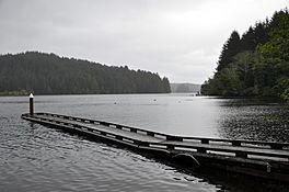
Tahkenitch Lake from near a boat launch along U.S. Route 101
|
|
| Location | Near Pacific Ocean coast in Douglas County, Oregon |
| Coordinates | 43°48′26″N 124°09′01″W / 43.80722°N 124.15028°W |
| Type | Natural, permanent, mesotrophic |
| Primary inflows | Fivemile and Leitel creeks |
| Primary outflows | Tahkenitch Creek |
| Catchment area | 34 square miles (88 km2) |
| Basin countries | United States |
| Surface area | 2,118 acres (857 ha) |
| Average depth | 11 feet (3.4 m) |
| Max. depth | 23 feet (7.0 m) |
| Water volume | 18,200 acre-feet (22,400,000 m3) |
| Residence time | 2 months |
| Shore length1 | 29 miles (47 km) |
| Surface elevation | 20 feet (6 m) |
| Islands | Weed, Jewitt |
| 1 Shore length is not a well-defined measure. | |
Tahkenitch Lake is one of the biggest lakes along the coast of Oregon, a state in the United States. It covers about 2,118 acres (857 ha), which is like having over 1,600 football fields! The lake gets its water from a large area around it, about 34 square miles (88 km2) in size.
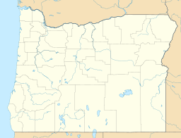
You can find Tahkenitch Lake in Douglas County, east of U.S. Route 101. It's located between the towns of Florence and Reedsport. The name "Tahkenitch" comes from a local Native American language called Lower Umpqua (Siuslaw). It means "having arms running out like a crab," which describes the lake's shape very well!
How Tahkenitch Lake Was Formed
Tahkenitch Lake, along with its nearby neighbor Siltcoos Lake, was created a long, long time ago. This happened during and after the Pleistocene Ice Age, a period when huge glaciers covered much of the Earth. As these glaciers melted, the sea level rose.
When the sea level went up, it flooded the lower parts of Oregon's coastal rivers. Big rivers, like the Umpqua to the south, formed wide, open areas where river water mixes with sea water, called estuaries. But smaller streams filled up with sand and dirt, which eventually formed large sand dunes.
Tahkenitch Lake, Siltcoos Lake, Woahink Lake, and other lakes nearby formed behind these sand dunes. Even today, the lake's surface is about 20 feet (6 m) above sea level.
Exploring Tahkenitch Lake's Features
Tahkenitch Lake gets most of its water from Fivemile and Leitel creeks, plus several smaller streams. These include Elbow Lake, Mallard, and John Sims creeks. The lake is not very deep, with an average depth of about 11 feet (3.4 m). The deepest spot is about 23 feet (7.0 m).
Water leaves the lake from its west end through Tahkenitch Creek. This creek flows under Route 101 and into the Oregon Dunes National Recreation Area. It then winds its way less than a mile before reaching the Pacific Ocean. Of all the creeks that flow into the lake, only Fivemile Creek has smaller streams joining it, named Perkins, Harry, and Bell creeks.
There's a small dam at the west end of the lake. It was originally built to help keep a steady supply of fresh water for a paper mill in Gardiner. The lake has a shape that looks like the branches of a tree, which is called "dendritic." Many of these branches have their own names!
Starting from the dam and going around the lake, some of the named branches include Shag Arm, Deer Arm, Big Arm, Catfish Cove, North Arm, Bear Trap Arm, Spike Arm, Fivemile Arm, Dismal Swamp, Cleves Cove, Cherry Arm, Mallard Arm, Bombard Bay, Bedolf Arm, and Bass Arms. The lake also has two named islands, Weed and Jewitt, both located toward the west end. On the east side, you'll find Leitel Marsh, which stretches about 2 miles (3 km) beyond the lake, and Fivemile Marsh, which is about twice as long.
Plants and Animals of Tahkenitch Lake
Most of the land around Tahkenitch Lake is covered by forests. These forests are mainly made up of Douglas fir trees, spruce trees, alder trees, and many different kinds of shrubs. About half of these forests have been harvested for wood at some point.
The lake is home to many different kinds of fish. You can find yellow perch, catfish, bluegill, and both smallmouth and largemouth bass. The lake is also stocked with rainbow trout and cutthroat trout. Sometimes, you might even find a few coho salmon and steelhead, which are rainbow trout that travel to the ocean.
It can be hard to fish from the shore because of the thick bushes. However, fishing from boats is a great way to catch fish here. There are two public boat ramps off Highway 101, and you can also find the Tahkenitch Landing Campground nearby. An RV (recreational vehicle) resort at the lake also rents out boats and fishing gear.
One plant that causes problems in the lake is Brazilian waterweed. This weed has formed a thick mat over most of the lake bottom. It makes it difficult for people to swim, boat, and fish. This plant was introduced to the lake in the 1930s and has been very hard to control.
 | Madam C. J. Walker |
 | Janet Emerson Bashen |
 | Annie Turnbo Malone |
 | Maggie L. Walker |


