
Tatra Mountains facts for kids
Quick facts for kids Tatra Mountains |
|
|---|---|

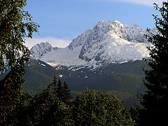
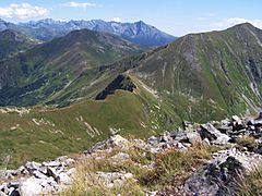
Bird's-eye view of Western Tatras
|
|
| Highest point | |
| Peak | Gerlachovský štít |
| Elevation | 2,655 m (8,711 ft) |
| Geography | |
 |
|
| Countries | Slovakia and Poland |
| Range coordinates | 49°10′N 20°08′E / 49.167°N 20.133°E |
| Parent range | Western Carpathians |

The Tatra Mountains, also called the Tatras, are a stunning mountain range. They are part of the Western Carpathians and form a natural border between Slovakia and Poland. These are the highest mountains in the entire Carpathian range. It's important not to confuse them with the Low Tatras in Slovakia, which are a different mountain range.
The Tatra Mountains cover an area of about 785 square kilometers (303 square miles). Most of this area, about 610 square kilometers (236 square miles), is in Slovakia. The remaining 175 square kilometers (68 square miles) are in Poland. The tallest peak is Gerlachovský štít, standing at 2,655 meters (8,710 feet) high. This peak is entirely within Slovakia, north of Poprad. The highest point in Poland is Rysy, at 2,499 meters (8,200 feet). It sits right on the border with Slovakia, south of Zakopane.
The Tatras stretch for about 57 kilometers (35 miles) in a straight line. If you measure along their main ridge, they are about 80 kilometers (50 miles) long. The range is only about 19 kilometers (12 miles) wide. The main ridge goes from the village of Huty in the west to the village of Ždiar in the east.
Today, the Tatras are protected by law. Both the Tatra National Park, Slovakia and the Tatra National Park, Poland were created to keep them safe. These parks are even part of UNESCO's World Network of Biosphere Reserves. In 1992, UNESCO officially recognized them together as a special transboundary reserve.
Contents
What's in the Tatra Mountains?

The Tatras are a rugged mountain range. They were formed by the same powerful forces that created the Alps. This means they have a similar, dramatic look, even though they are much smaller. They are the highest mountains in the entire Carpathian range.
The Tatras are divided into different parts:
- The Eastern Tatras (called Východné Tatry in Slovak and Tatry Wschodnie in Polish). These include:
- The Belianske Tatras (Belianske Tatry in Slovak, Tatry Bielskie in Polish).
- And the High Tatras (Vysoké Tatry in Slovak, Tatry Wysokie in Polish).
- The Western Tatras (Západné Tatry in Slovak, Tatry Zachodnie in Polish).
Because they are so beautiful and easy to reach, the Tatras are very popular. Many tourists and researchers visit them. They are a great place for winter sports, with famous resorts like Poprad and the town of Vysoké Tatry in Slovakia. This town was created in 1999 and includes places like Štrbské Pleso, Starý Smokovec, and Tatranská Lomnica. On the Polish side, Zakopane is known as the "winter capital of Poland." The High Tatras have 24 or 25 peaks that are over 2,500 meters (8,200 feet) high. Along with the Southern Carpathians, they are the only truly alpine (high-mountain) landscapes in the 1,200-kilometer (750-mile) long Carpathian arc.
How Borders Changed in the Tatras
For a long time, the exact border between the Kingdom of Hungary and the First Polish Republic in the Tatras wasn't clear. This area became an unclaimed borderland. In 1770, an Austrian army entered Polish land, supposedly to stop a plague. They took control of areas like Spiš and Podhale. Two years later, in 1772, these lands officially became part of Austria during the First Partition of Poland.
In 1824, a Hungarian man bought the Zakopane region and the area around Morskie Oko from the Austrian Empire. When Austria-Hungary was formed in 1867, the Tatra Mountains became a natural border between the two parts of this dual monarchy. But the border was still not perfectly set. In 1889, a Polish Count bought the Zakopane region and Morskie Oko. Because of many arguments over land ownership, people tried to draw the border more clearly in the late 1800s. These efforts didn't work until 1897. Finally, an international court decided the exact border on September 13, 1902.
After World War I, Poland and Czechoslovakia became new countries. This led to new arguments about the border. Poland claimed a large part of the Spiš region, which included more of the Tatra Mountains. After several years of small conflicts, a treaty was signed in 1925. Poland received a small part of Spiš, but it didn't change the border within the mountains themselves. During World War II, both sides tried to take more land. However, the final treaty signed in 1958 kept the border line agreed upon in 1925. This border is still in place today.
Crossing the Border for Hikers
When the Austrian Empire fell in 1918, the Tatra Mountains were split by an international border. This made hiking difficult. It was against the law to cross the border without going through an official checkpoint. For many years, there were no checkpoints for hikers on the mountain ridge. If you crossed elsewhere, you could be fined or even arrested by border police.
However, the border was also used for smuggling goods like tobacco and coffee. Things finally got better in 1999. Poland and Slovakia signed an agreement to create several unstaffed border crossings for hikers and cyclists. One of these was on the summit of Rysy peak in the Tatras. But many other trails still crossed the border illegally. This changed in 2007 when both countries joined the Schengen Area. Now, it's legal to cross the border at any point. However, the rules of the national parks still apply. They limit movement to official hiking trails and often close trails seasonally to protect wildlife.
Weather in the Tatras

The Tatras are located in the middle of Europe. They act like a big wall against moving air masses, which creates a very varied climate.
Rain and Snow
The most rain and snow fall on the northern slopes. In June and July, about 250 millimeters (10 inches) of precipitation can fall each month. It rains or snows on 215 to 228 days a year. Thunderstorms happen about 36 days a year.
The deepest snow can be:
- In Poland, at Kasprowy Wierch: 355 centimeters (140 inches).
- In Slovakia, at Lomnický Štít: 410 centimeters (160 inches).
Some peaks can have snow or ice all year round. Avalanches are common.
Temperatures
Temperatures can be very cold, dropping to -40°C (-40°F) in winter. In warmer months, they can reach 33°C (91°F). Temperatures also change depending on how high up you are and how much sun a slope gets. On the mountain tops, temperatures stay below 0°C (32°F) for 192 days a year.
Winds

The average wind speed on the summits is 6 meters per second (13 miles per hour).
- Southerly winds blow on the northern side.
- Westerly winds blow at the base of the Tatras.
- Strong, warm, and dry winds called foehn winds (or halny in Polish) often occur between October and May. These winds can cause a lot of damage.
The fastest wind ever recorded was 288 kilometers per hour (179 miles per hour) on May 6, 1968.
On November 19, 2004, a very strong wind storm damaged large parts of the forests in the Slovak High Tatras. Three million cubic meters of trees were blown down. Two people died, and several villages were completely cut off. A later forest fire caused even more damage. It will take many years for the natural environment to fully recover.
Plants of the Tatras

The Tatra Mountains have a huge variety of plant life. They are home to over 1,000 different kinds of vascular plants (plants with roots, stems, and leaves). There are also about 450 types of mosses, 200 liverworts, 700 lichens, 900 fungi, and 70 slime moulds. The plants grow in five different zones based on altitude:
- Up to 1,300 meters (4,265 feet): You'll find beech forests here. There are almost no shrubs, but many herbs cover the forest floor.
- To 1,550 meters (5,085 feet): This zone has Spruce forests. There are not many shrubs, but mosses are very common.
- To 1,800 meters (5,905 feet): Here, you'll see Mountain Pine trees and many different herbs.
- To 2,300 meters (7,545 feet): This area is mostly high-altitude grasslands.
- From 2,300 meters (7,545 feet) up: This is the Subnivean zone. It's mostly bare rock with very little plant life, mainly lichens.
Animals of the Tatras
.JPG)
The Tatra Mountains are home to many different animal species. This includes 54 types of tardigrades (tiny creatures), 22 turbellarians (flatworms), 100 rotifers (microscopic animals), 22 copepods (small crustaceans), 162 spiders, 81 molluscs, 43 mammals, 200 birds, 7 amphibians, and 2 reptiles.
Some of the most famous mammals living here are the Tatra chamois (a type of goat-antelope), marmots, snow voles, brown bears, wolfes, Eurasian lynxes, red deer, roe deer, and wild boars. In the waters, you can find fish like the brown trout and alpine bullhead.
Some unique insects and spiders that live only in the Tatras include a type of caddis fly, the spider Xysticus alpicola, and a springtail.
Tallest Peaks in the Tatras
-
Gerlachovský štít (2,655 meters or 8,710 feet), the highest peak in Slovakia.
-
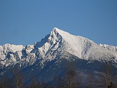
Kriváň (2,495 meters or 8,186 feet), a symbol of Slovakia found on their euro coins.
-
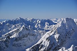
View from Lomnický štít (2,634 meters or 8,642 feet).
-
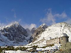
Skalnaté pleso Observatory (1,751 meters or 5,745 feet).
-
Bystrá (2,248 meters or 7,375 feet).
-
Kościelec (2,155 meters or 7,070 feet).


Eastern Tatras Peaks
- Gerlachovský štít - 2,655 m (Slovakia)
- Lomnický štít - 2,634 m (Slovakia)
- Ľadový štít - 2,627 m (Slovakia)
- Pyšný štít - 2,621 m (Slovakia)
- Zadný Gerlach - 2,616 m (Slovakia)
- Lavínový štít - 2,606 m (Slovakia)
- Ľadová kopa - 2,602 m (Slovakia)
- Kotlový štít - 2,601 m (Slovakia)
- Malý Pyšný štít - 2,592 m (Slovakia)
- Kežmarský štít - 2,558 m (Slovakia)
- Vysoká - 2,547 m (Slovakia)
- Končistá - 2,538 m (Slovakia)
- Baranie rohy - 2,526 m (Slovakia)
- Dračí štít - 2,523 m (Slovakia)
- Ťažký štít - 2,520 m (Slovakia)
- Malý Kežmarský štít - 2,513 m (Slovakia)
- Rysy - 2,503 m (Slovakia/Poland)
- Kriváň - 2,495 m (Slovakia)
- Slavkovský štít - 2,452 m (Slovakia)
- Batizovský štít - 2,448 m (Slovakia)
- Veľký Mengusovský štít (Slovak); Mięguszowiecki Szczyt Wielki (Polish) - 2,438 m (Slovakia/Poland)
- Malé Rysy (Slovak); Niżnie Rysy (Polish) - 2,430 m (Slovakia/Poland)
- Východna Vysoka - 2,429 m (Slovakia)
- Východný Mengusovský štít (Slovak); Mięguszowiecki Szczyt Czarny (Polish) - 2,410 m (Slovakia/Poland)
- Prostredný Mengusovský štít (Slovak); Mięguszowiecki Szczyt Pośredni (Polish) - 2,393 m (Slovakia/Poland)
- Čubrina (Slovak); Cubryna (Polish) - 2,376 m (Slovakia/Poland)
- Svinica (Slovak); Świnica (Polish) - 2,301 m (Slovakia/Poland)
- Kozi Wierch - 2,291 m (Poland)
- Jahňaci štít - 2,230 m (Slovakia)
- Zamarła Turnia - 2,179 m (Poland)
- Kościelec - 2,155 m (Poland)
- Mnich - 2,068 m (Poland)
Western Tatras Peaks
- Bystrá - 2,248 m (Slovakia)
- Jakubina - 2,194 m (Slovakia)
- Baranec - 2,184 m (Slovakia)
- Baníkov - 2,178 m (Slovakia)
- Klin (Slovak); Starorobociański Wierch (Polish) - 2,176 m (Slovakia/Poland)
- Pachoľa - 2,167 m (Slovakia)
- Hrubá kopa - 2,166 m (Slovakia)
- Nižná Bystrá - 2,163 m (Slovakia)
- Štrbavy - 2,149 m (Slovakia)
- Jalovecký príslop - 2,142 m (Slovakia)
- Hrubý vrch (Slovak); Jarząbczy Wierch (Polish) - 2,137 m (Slovakia/Poland)
- Tri kopy - 2,136 m (Slovakia)
- Veľká Kamenistá (Slovak); Kamienista (Polish) - 2,126 m (Slovakia/Poland)
- Krzesanica - 2,122 m (Slovakia/Poland) - summit of Czerwone Wierchy / Red Mountains
- Volovec (Slovak); Wołowiec (Polish) - 2,064 m (Slovakia/Poland)
- Kasprov vrch (Slovak); Kasprowy Wierch (Polish) - 1,987 m (Slovakia/Poland)
- Giewont - 1,894 m (Poland)
- Sivý vrch - 1,809 m (Slovakia)
Visiting the Tatras

In 1683, a book about adventures in the Tatras was published. It became very popular and helped tourism grow. The author was Daniel Speer, who lived near the Tatras for a while.
A popular place to visit in Poland is Zakopane. Other tourist towns include Kościelisko, Poronin, Biały Dunajec, Bukowina Tatrzańska, Białka Tatrzańska, Murzasichle, Małe Ciche, Ząb, Jurgów, and Brzegi.
In Slovakia, the main tourist area is the city of Vysoké Tatry. This city is made up of three parts: Štrbské Pleso, Starý Smokovec, and Tatranská Lomnica.
The Polish "national mountain" is Giewont, which appears in many myths. The Slovak national mountain is Kriváň.
Hiking Trails

Orla Perć is known as the most difficult and dangerous hiking trail in the Tatras. It's only for experienced hikers and climbers. This trail is entirely in the Polish part of the Tatras. It was planned in 1901 and built between 1903 and 1906. More than 100 people have died on this route since it opened. The path is marked with red signs. Guides often tell the story of Polish philosopher Bronisław Bandrowski, who died after being stuck for days on a rocky ledge near Zakopane, as a warning to tourists.
The highest point in the Tatra Mountains that you can reach on a marked hiking trail is Rysy.
Most peaks in the Western Tatras, on both sides of the border, can be reached by hiking trails. However, in the Slovak part of the Eastern Tatras, only seven peaks have hiking trails. These are Rysy, Svinica/Świnica, Slavkovský štít, Kriváň, Kôprovský štít, Východná Vysoká, and Jahňací štít. Two of these, Rysy and Svinica/Świnica, are on the border and can be reached from Poland. Other peaks in Slovakia, including the highest one, Gerlachovský štít, can only be climbed with a certified mountain guide.
In the Slovak Tatras, most hiking trails are closed from November 1st to June 15th. Only trails leading to mountain huts stay open. In Poland, the trails are open all year round.
How Humans Impact the Tatras
In the 1700s and 1800s, people used the mountains for grazing sheep and for mining. Many trees were cut down. Even though these activities have stopped, their effects can still be seen. Also, pollution from industrial areas like Kraków in Poland and Ostrava in the Czech Republic, along with too much tourism, causes damage. But many volunteers often organize clean-up events on both sides of the border.
The Slovak Tatra National Park (TANAP) was created in 1949, covering 738 square kilometers (285 square miles). The Polish Tatra National Park was created in 1954, covering 215.56 square kilometers (83.23 square miles). Both parks were added to the UNESCO Biosphere Reserve list together in 1993.
In 2013, a group called the International Union for Conservation of Nature warned that they might remove the Slovak TANAP's national park status. This was because of large projects, mainly for skiing, that were changing the landscape and nature too much.
See also
 In Spanish: Montes Tatras para niños
- Mountain Rescue Service (Slovakia)
- Sudetes
- Tatrzańskie Ochotnicze Pogotowie Ratunkowe (Tatra Volunteer Search and Rescue (Poland))
- Tourism in Poland
