
Poprad facts for kids
Quick facts for kids
Poprad
|
|||
|---|---|---|---|
|
City
|
|||
|
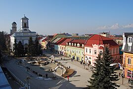
From the top, Central Poprad, Renaissance bell tower, Tatra Gallery
Central Poprad
|
|||
|
|||

Poprad
Location in Prešov Region

Poprad
Location in Slovakia
|
|||
| Country | |||
| Region | Prešov | ||
| District | Poprad | ||
| First mentioned | 1250 | ||
| Area | |||
| • Total | 63.09 km2 (24.36 sq mi) | ||
| (2022) | |||
| Elevation | 684 m (2,244 ft) | ||
| Population
(2022)
|
|||
| • Total | 49,091 | ||
| • Density | 778.11/km2 (2,015.30/sq mi) | ||
| Time zone | UTC+1 (CET) | ||
| • Summer (DST) | UTC+2 (CEST) | ||
| Postal code |
058 01
|
||
| Area code(s) | +421 52 | ||
| Car plate | PP | ||


Poprad is a city in northern Slovakia. It sits at the foot of the High Tatra Mountains. Poprad is known for its beautiful old town and as a popular place for holidays. It is the largest city in the Spiš region. It is also the biggest town near the High Tatra Mountains in both Slovakia and Poland. Poprad is the tenth largest city in Slovakia, with about 50,000 people living there.
The Poprad-Tatry Airport is an international airport right outside the city. Poprad is also where the Tatra Electric Railway starts. These are special narrow-gauge trains that connect the mountain resorts with each other and with Poprad. Regular trains link Poprad to other places in Slovakia and beyond. You can even take a direct train from Poprad to Prague in the Czech Republic.
Contents
History of Poprad
![]() Kingdom of Hungary 1256–1412
Kingdom of Hungary 1256–1412
![]() Kingdom of Poland 1412–1569
Kingdom of Poland 1412–1569
![]() Polish–Lithuanian Commonwealth 1569–1769
Polish–Lithuanian Commonwealth 1569–1769
![]() Kingdom of Hungary 1769–1867
Kingdom of Hungary 1769–1867
![]() Austria-Hungary 1867–1918
Austria-Hungary 1867–1918
![]() Czechoslovakia 1918–1939
Czechoslovakia 1918–1939
![]() Slovak Republic 1939–1945
Slovak Republic 1939–1945
![]() Czechoslovakia 1945–1990
Czechoslovakia 1945–1990
![]() Czech and Slovak Federative Republic 1990–1992
Czech and Slovak Federative Republic 1990–1992
![]() Slovak Republic 1993–present
Slovak Republic 1993–present
People called Slavic settlers lived in this area a long time ago. The first time Poprad was written about was on March 16, 1256. This was in a document from the Hungarian King Bela IV. After the Mongol invasions in the 1200s, German settlers moved here. The town became known as Deutschendorf, which means 'Germans' village'.
From 1412 to 1770, Poprad was part of a group of towns given by the Kingdom of Hungary to the Kingdom of Poland. This led to a strong Polish influence on the city. By the 1600s, the number of German people started to decrease. In 1918, the area became part of Czechoslovakia.
For 690 years, until 1946, Poprad was just one of several small towns. Today, these towns make up the modern city. Some of these older parts are Matejovce, Spišská Sobota, Veľká, and Stráže pod Tatrami. The most important of these was Spišská Sobota, which was a main town until the late 1800s.
Poprad grew more important after the Košice–Bohumín Railway was built in 1871. More railway lines were added later, like the one to Kežmarok in 1892 and the Tatra Electric Railway in 1908.
During World War II, many Jewish people were forced to leave Slovakia from the Poprad railway station. This happened in 1942.
Poprad was set free on January 28, 1945, by Soviet troops. After the war, the German population was asked to leave.
After the war, the nearby towns joined Poprad. These included Spišská Sobota and Veľká in 1945, Stráže pod Tatry in 1960, and Matejovce in 1974. As winter sports became popular, Poprad became a main starting point for trips into the High Tatras.
In 1999, Poprad tried to host the 2006 Winter Olympics. However, the games were given to Turin, Italy, instead.
Geography and Climate
Poprad is about 672 metres (2,205 ft) above sea level. It covers an area of about 63 square kilometres (24.3 sq mi). It is located in northeastern Slovakia. It is about 110 kilometres (68 mi) from Košice and 330 kilometres (205 mi) from Bratislava.
Poprad is on the Poprad River in the Sub-Tatra Basin. It is known as a gateway to the High Tatras. Mountains around the city include the Levoča Hills to the east and the Low Tatras to the southwest.
Climate in Poprad
Poprad has a climate with four clear seasons. Summers are warm, and winters are cold.
| Climate data for Poprad (1991–2020, extremes 1926–present) | |||||||||||||
|---|---|---|---|---|---|---|---|---|---|---|---|---|---|
| Month | Jan | Feb | Mar | Apr | May | Jun | Jul | Aug | Sep | Oct | Nov | Dec | Year |
| Record high °C (°F) | 12.3 (54.1) |
18.2 (64.8) |
22.3 (72.1) |
27.0 (80.6) |
31.2 (88.2) |
33.8 (92.8) |
34.8 (94.6) |
33.9 (93.0) |
31.5 (88.7) |
29.2 (84.6) |
20.5 (68.9) |
16.3 (61.3) |
34.8 (94.6) |
| Mean daily maximum °C (°F) | 0.5 (32.9) |
2.7 (36.9) |
7.1 (44.8) |
13.5 (56.3) |
18.1 (64.6) |
21.7 (71.1) |
23.4 (74.1) |
23.7 (74.7) |
18.3 (64.9) |
12.9 (55.2) |
6.6 (43.9) |
1.2 (34.2) |
12.5 (54.5) |
| Daily mean °C (°F) | −3.7 (25.3) |
−2.3 (27.9) |
1.4 (34.5) |
7.2 (45.0) |
12.0 (53.6) |
15.6 (60.1) |
17.0 (62.6) |
16.6 (61.9) |
11.7 (53.1) |
7.0 (44.6) |
2.2 (36.0) |
−2.6 (27.3) |
6.8 (44.2) |
| Mean daily minimum °C (°F) | −8.0 (17.6) |
−6.9 (19.6) |
−3.3 (26.1) |
1.2 (34.2) |
5.9 (42.6) |
9.3 (48.7) |
10.9 (51.6) |
10.5 (50.9) |
6.4 (43.5) |
2.2 (36.0) |
−1.6 (29.1) |
−6.5 (20.3) |
1.7 (35.1) |
| Record low °C (°F) | −29.1 (−20.4) |
−33.1 (−27.6) |
−26.7 (−16.1) |
−12.8 (9.0) |
−6.6 (20.1) |
−2.9 (26.8) |
0.4 (32.7) |
0.1 (32.2) |
−6.6 (20.1) |
−13.2 (8.2) |
−19.5 (−3.1) |
−30.5 (−22.9) |
−33.1 (−27.6) |
| Average precipitation mm (inches) | 25.0 (0.98) |
27.4 (1.08) |
30.3 (1.19) |
43.2 (1.70) |
75.5 (2.97) |
84.0 (3.31) |
101.5 (4.00) |
79.2 (3.12) |
56.0 (2.20) |
51.1 (2.01) |
36.6 (1.44) |
26.9 (1.06) |
636.6 (25.06) |
| Average precipitation days (≥ 1.0 mm) | 6.2 | 6.6 | 6.8 | 7.6 | 10.4 | 10.5 | 11.3 | 8.6 | 7.7 | 7.1 | 6.8 | 6.3 | 95.9 |
| Average snowy days | 16.5 | 14.8 | 12.8 | 4.6 | 0.3 | 0.0 | 0.0 | 0.0 | 0.0 | 2.6 | 8.3 | 14.5 | 74.4 |
| Average relative humidity (%) | 80.7 | 76.8 | 70.9 | 67.4 | 69.8 | 72.0 | 72.0 | 73.2 | 76.7 | 79.5 | 82.4 | 84.4 | 75.5 |
| Mean monthly sunshine hours | 86.6 | 107.9 | 160.7 | 189.8 | 223.3 | 227.1 | 237.7 | 239.5 | 178.2 | 142.7 | 87.5 | 68.7 | 1,949.7 |
| Source 1: NOAA | |||||||||||||
| Source 2: SHMI (extremes, 1926–present) | |||||||||||||
People of Poprad
| Historical population | ||
|---|---|---|
| Year | Pop. | ±% |
| 1970 | 23,447 | — |
| 1980 | 38,077 | +62.4% |
| 1991 | 52,914 | +39.0% |
| 2001 | 56,157 | +6.1% |
| 2011 | 52,862 | −5.9% |
| 2021 | 49,855 | −5.7% |
| Source: Censuses | ||
As of December 31, 2005, Poprad had a population of 55,158 people. Most of the people living in Poprad are Slovaks. There are also smaller groups of Romani, Czechs, Hungarians, Germans, and others.
Religion in Poprad
The oldest churches in Poprad are the Roman Catholic Church and the Lutheran Church. Other churches and religious groups also have places of worship here. These include the Greek Catholic Church, Orthodox Church, Baptists, and Jehovah's Witnesses.
Famous Places in Poprad
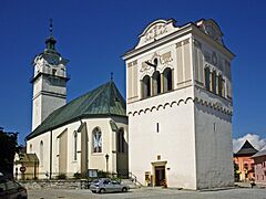
The historic center of Poprad is around St. Giles Square (Námestie svätého Egídia). This square is surrounded by old houses, mostly from the 1700s and 1800s. Important churches in the city include the old Gothic Catholic Church of St. Giles from the late 1200s. There is also the classicist Lutheran Church of Holy Trinity from the 1800s.
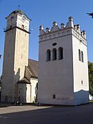
Another historic area is Spišská Sobota. This place was named a Town Monument Reserve in 1953. A key landmark there is the Church of St. George. It has five old Gothic altars and a main altar made by Master Paul of Levoča.
Modern places to visit include the Poprad-Tatry railway station and the AquaCity Poprad water park.
-
St. Giles Square with the Lutheran Church of Holy Trinity
-
Church of St. Giles
-
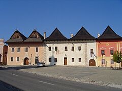
Main Square in Spišská Sobota
-
Church in Spišská Sobota
-
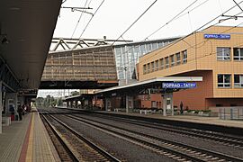
Poprad-Tatry railway station


City Parts and Sports
The city of Poprad is divided into six main areas for local government. These are:
- Staré Mesto ("Old Town")
- Spišská Sobota
- Stráže
- Veľká
- Matejovce
- Kvetnica
Sports in Poprad

Poprad has an ice hockey team called HK Poprad. They play at the Poprad Ice Stadium.
Another ice hockey team, Lev Poprad, used to play in Poprad. They were part of the KHL for one season. Many ice hockey players who have played in the NHL were born in Poprad.
The city has also hosted several big sports events. These include the 1994 Men's Ice Hockey World Championships and the 2017 IIHF World U18 Championships. Every year, the city holds the Tatra Cup ice hockey tournament.
There are many football stadiums in Poprad. The main one is NTC Poprad. This is the home stadium for the FK Poprad football club, which started in 1906. It is also used by the Slovakia national youth football teams.
Poprad also has a women's basketball team called Basketbalová Akadémia Mládeže Poprad (BAMP). They play their games in Aréna Poprad. This arena also hosted games for the 2017 FIVB Volleyball World League.
Education in Poprad
Poprad has 12 public primary schools and one religious primary school. About 5,464 students attend these schools. For older students, there are four high schools with 1,800 students. There are also three specialized high schools and four vocational schools.
Getting Around Poprad

Poprad is a great starting point for visiting the High Tatras mountains. The city is on the main road (E 50) and railway that connect western and eastern Slovakia.
The Poprad-Tatry railway station connects Poprad to other big cities in Slovakia. It also links to the mountains using the metre gauge Tatra Electric Railway. You can even take a direct train called SuperCity Pendolino from Poprad to Prague.
The international Poprad–Tatry Airport opened in 1938. It is the airport with the highest elevation in Central Europe. You can find scheduled flights from here to London.
Bus and Rail Lines
- Bus lines: 1, 2, 3, 4, 5, 6, 7, 8
- Rail lines: 183, 185
Famous People from Poprad

Many notable people were born or grew up in Poprad, including:
- Daniela Hantuchová – a professional tennis player who won Grand Slam titles.
- Peter Bondra – an ice hockey player who scored over 500 goals in the NHL.
- Jan Brokoff – a famous sculptor from the Baroque period (born in Spišská Sobota).
- Adolf Burger – an author whose life story was made into the Oscar-winning movie The Counterfeiters.
- Andrej Kiska – a businessman who became a former president of Slovakia.
- Miroslav Lajčák – a well-known diplomat.
Sister Cities
Poprad has "sister city" relationships with several other cities around the world. This means they share cultural and educational ties. These cities include:
See also
 In Spanish: Poprad para niños
