
Bratislava facts for kids
Quick facts for kids
Bratislava
|
|||||
|---|---|---|---|---|---|
|
Clockwise from top: View of Bratislava; Financial district; Old Town streets; Grassalkovich Palace; Blue Church; View of Old Town
|
|||||
|
|||||
| Nicknames:
Beauty on the Danube, Little Big City
|
|||||

Bratislava
Location in Slovakia

Bratislava
Location in Bratislava Region

Bratislava
Location in Europe
|
|||||
| Country | |||||
| Region | |||||
| First mentioned | 907 | ||||
| Area | |||||
| • Capital city | 367.584 km2 (141.925 sq mi) | ||||
| • Urban | 853.15 km2 (329.40 sq mi) | ||||
| • Metro | 2,053 km2 (792.66 sq mi) | ||||
| Elevation | 134 m (440 ft) | ||||
| Population
(2022)
|
|||||
| • Metro | 728,370 | ||||
| • Capital city census | 476,922 | ||||
| • Capital city estimate | 660,000 | ||||
| • Capital city estimate density | 1,297/km2 (3,360/sq mi) | ||||
| Demonym(s) | |||||
| GDP | |||||
| • Capital city | €30.7 billion (2022) | ||||
| • Per capita | €42,679 (2022) | ||||
| Time zone | UTC+1 (CET) | ||||
| • Summer (DST) | UTC+2 (CEST) | ||||
| Postal code |
8XX XX
|
||||
| Area code(s) | 421 2 | ||||
| Car plate | BA, BL, BT | ||||


.jpg)


Bratislava is the capital and largest city of Slovakia. It is also the fourth largest city located on the River Danube. About 475,000 people officially live here. However, some guess the number is closer to 660,000.
Bratislava is in southwestern Slovakia. It sits at the foot of the Little Carpathians mountains. The city is on both sides of the River Danube and the left side of the River Morava. It borders Austria and Hungary. This makes it the only capital city that touches two other countries.
Many different groups have shaped the city's history. These include Austrians, Bulgarians, Croats, Czechs, Germans, Hungarians, Jews, and Slovaks. Bratislava was once the capital of the Kingdom of Hungary from 1563 to 1783. Many Hungarian kings and queens were crowned there.
Today, Bratislava is the main political, cultural, and economic center of Slovakia. It is where the Slovak president, the parliament, and the Slovak Executive are located. The city has many universities, museums, theaters, and art galleries. Many big Slovak businesses and banks also have their main offices here.
Bratislava is the 57th largest city in the European Union. It is also one of the richest regions in the EU. Its economy is about three times stronger than other parts of Slovakia. Around one million tourists visit Bratislava each year. Most come from the Czech Republic, Germany, and Austria.
Contents
What's in a Name?
The city got its current name, Bratislava, on March 16, 1919. Before that, it was mostly known as "Pressburg" in English. This name came from its German name, Preßburg. After 1526, the city was mainly ruled by the Habsburg monarchy. Many German people lived there. The older Slovak name, Prešporok, and Czech name, Prešpurk, came from "Pressburg."
A language expert named Ján Stanislav thought the Hungarian name, Pozsony, came from a prince named Božan. He might have owned the castle before 950. However, no old records confirm this. Still, old names like Vratislaburgum (905) and Braslavespurch (907) are similar.
The modern name "Bratislava" came from a mistake. A scholar thought an old name, Braslav, was Bratislav. This led to the name Břetislaw, which later became Bratislav.
During a time of big changes in 1918–1919, some American Slovaks suggested naming the city 'Wilsonov' or 'Wilsonstadt'. This was after US President Woodrow Wilson, who supported countries choosing their own future. But the name Bratislava became official in March 1919. This Slavic name helped show that the city should be part of Czechoslovakia.
Other old names for the city include Istropolis (meaning 'Danube City') and Posonium.
Bratislava's Story
The first people settled in this area around 5000 B.C. during the Stone Age. Around 200 B.C., the Celtic Boii tribe built a strong, fortified town called an oppidum. They also made their own gold and silver coins called biatecs.

The area was part of the Roman Empire from the 1st to the 4th century A.D. It was a border defense system called the Danubian Limes. The Romans brought grape growing to the area. This started a long tradition of winemaking that still exists today.

Slavs arrived from the East between the 5th and 6th centuries. In the 9th century, the castles at Bratislava and Devín were important centers for Slavic states.
The first time "Brezalauspurc" was written down was in 907. This was about the Battle of Pressburg, where a Bavarian army lost to the Hungarians. This battle was part of the fall of Great Moravia.


In the 10th century, Pressburg became part of the Kingdom of Hungary. It grew into an important trading and administrative center. In 1291, King Andrew III gave the city its first "town privileges." In 1405, King Sigismund declared it a free royal town. He also let the town use its own coat of arms in 1436.
The Ottoman Empire defeated the Kingdom of Hungary in 1526. The Ottomans attacked Pressburg but could not conquer it. Because the Ottomans were moving into Hungarian lands, Pressburg became the new capital of Hungary in 1536. This was the start of a new time under the Habsburg monarchy. The city became a place where kings were crowned. It also became home to archbishops, nobles, and important offices. Between 1536 and 1830, eleven Hungarian kings and eight queens were crowned at St Martin's Cathedral.
The 17th century was a tough time. There were rebellions against the Habsburgs, fights with the Ottomans, floods, and plagues. These events reduced the population. A very bad plague in 1678–1681 caused about 11,000 deaths. The city's population was around 30,000 at that time.


Pressburg thrived during the 18th century under Queen Maria Theresa. It became the largest and most important town in the Kingdom of Hungary. The population grew three times larger. Many new palaces, monasteries, and streets were built. The city became a center for social and cultural life. Famous musicians like Wolfgang Amadeus Mozart, Joseph Haydn, and Ludwig van Beethoven performed here.
The city started to lose its importance under Maria Theresa's son, Joseph II. The crown jewels were moved to Vienna in 1783. Many government offices and nobles then moved to Buda. The first newspapers in Hungarian and Slovak were published here. The city also became a center for the Slovak national movement.


The 19th century was shaped by big events in Europe. The Peace of Pressburg was signed here in 1805. Napoleon's French troops destroyed Devín Castle in 1809. In 1811, a huge fire ruined Bratislava Castle. It stayed in ruins until the 1950s.
Industry grew quickly in the 19th century. The first horse-drawn railway in Hungary was built here in 1840. New train lines to Vienna and Pest opened later. The city's first permanent bridge over the Danube, Starý most (Old Bridge), was built in 1891.
Before World War I, about 42% of the people in Pressburg spoke German. 41% spoke Hungarian, and 15% spoke Slovak. After the war, Czechoslovakia was formed. The city's name became Bratislava in March 1919. Many Hungarians and Germans left or were asked to leave. More Slovaks and Czechs moved in. By 1930, the Hungarian population was much smaller.


In 1938, Nazi Germany took over neighboring Austria. They also took parts of Bratislava, like Petržalka and Devín, because many Germans lived there. Bratislava became the capital of the first independent Slovak Republic in 1939. But this new state was strongly influenced by the Nazis. Many Jewish people living in Bratislava were forced to leave their homes during this time, and sadly, many did not survive.

Bratislava was bombed by the Allies during World War II. On April 4, 1945, the Soviet Red Army took the city. After the war, many Germans living in Bratislava had to leave the city.
Bratislava was reunited with the Czech Republic as Czechoslovakia. Some villages south of Bratislava were also added to the city.


After the Communist Party took power in 1948, Bratislava became part of the Eastern Bloc. The city grew, and its population became mostly Slovak. Large apartment buildings were built, like those in Petržalka. The Communist government also built new big buildings, such as the Slovak Radio Building. A part of the Old Town was taken down to build the Bridge of the Slovak National Uprising. This included a historic Jewish quarter.
In 1968, the city was occupied by troops from the Warsaw Pact. Soon after, Bratislava became the capital of the Slovak Socialist Republic. This was one of the two states in Czechoslovakia.
People in Bratislava showed their desire for change in 1988. The city became a main center of the peaceful Velvet Revolution in 1989. This led to the end of Communist rule.
In 1993, Bratislava became the capital of the newly independent Slovak Republic. This happened after Czechoslovakia peacefully split into two countries.
Where is Bratislava?


Bratislava is in southwestern Slovakia, in the Bratislava Region. It is special because it borders both Austria and Hungary. This makes it the only capital city that touches two countries. It is only 18 kilometers (11 miles) from the border with Hungary. It is also only 60 kilometers (37 miles) from the Austrian capital, Vienna.
The city covers 367.58 square kilometers (141.92 sq mi). This makes it the second-largest city in Slovakia by area. The Danube River flows through the city from west to southeast. The Carpathian mountain range starts in the city with the Little Carpathians. The lowest point in the city is at the Danube's surface, 126 meters (413 ft) above sea level. The highest point is Devínska Kobyla at 514 meters (1,686 ft).
Weather in Bratislava
Bratislava has a mild climate with four clear seasons. It can be windy, and there are big differences between hot summers and cold, humid winters. Snow falls less often than it used to. The city is one of the warmest and driest parts of Slovakia.
Some areas, like Devín, can get floods from the Danube and Morava rivers. New flood protection has been built to help.
| Climate data for Bratislava Airport (1991–2020 normals, extremes 1951–present) | |||||||||||||
|---|---|---|---|---|---|---|---|---|---|---|---|---|---|
| Month | Jan | Feb | Mar | Apr | May | Jun | Jul | Aug | Sep | Oct | Nov | Dec | Year |
| Record high °C (°F) | 19.8 (67.6) |
19.7 (67.5) |
25.0 (77.0) |
30.3 (86.5) |
33.4 (92.1) |
36.3 (97.3) |
38.2 (100.8) |
39.4 (102.9) |
34.0 (93.2) |
28.0 (82.4) |
21.6 (70.9) |
17.9 (64.2) |
39.4 (102.9) |
| Mean daily maximum °C (°F) | 3.1 (37.6) |
5.8 (42.4) |
11.1 (52.0) |
17.5 (63.5) |
21.7 (71.1) |
25.6 (78.1) |
28.0 (82.4) |
27.9 (82.2) |
21.9 (71.4) |
15.6 (60.1) |
9.3 (48.7) |
3.7 (38.7) |
15.9 (60.6) |
| Daily mean °C (°F) | 0.3 (32.5) |
1.9 (35.4) |
6.1 (43.0) |
11.7 (53.1) |
16.2 (61.2) |
20.2 (68.4) |
22.0 (71.6) |
21.5 (70.7) |
16.2 (61.2) |
10.7 (51.3) |
5.7 (42.3) |
1.1 (34.0) |
11.1 (52.0) |
| Mean daily minimum °C (°F) | −2.8 (27.0) |
−1.7 (28.9) |
1.7 (35.1) |
5.7 (42.3) |
10.6 (51.1) |
14.2 (57.6) |
16.2 (61.2) |
15.9 (60.6) |
11.2 (52.2) |
6.3 (43.3) |
2.6 (36.7) |
−1.5 (29.3) |
6.5 (43.7) |
| Record low °C (°F) | −24.6 (−12.3) |
−24.6 (−12.3) |
−16.4 (2.5) |
−5.0 (23.0) |
−1.6 (29.1) |
2.7 (36.9) |
4.4 (39.9) |
4.8 (40.6) |
−1.7 (28.9) |
−7.6 (18.3) |
−12.5 (9.5) |
−20.3 (−4.5) |
−24.6 (−12.3) |
| Average precipitation mm (inches) | 37.4 (1.47) |
32.9 (1.30) |
36.8 (1.45) |
35.9 (1.41) |
58.6 (2.31) |
59.2 (2.33) |
61.8 (2.43) |
60.5 (2.38) |
58.6 (2.31) |
43.6 (1.72) |
46.2 (1.82) |
42.7 (1.68) |
574.3 (22.61) |
| Average precipitation days (≥ 1.0 mm) | 13.2 | 11.4 | 11.7 | 9.2 | 11.3 | 10.9 | 11.5 | 10.0 | 9.6 | 11.2 | 12.5 | 13.6 | 136.1 |
| Average snowy days | 11.2 | 8.7 | 5.8 | 1.3 | 0.0 | 0.0 | 0.0 | 0.0 | 0.0 | 0.2 | 4.1 | 8.6 | 39.8 |
| Average relative humidity (%) | 80.9 | 74.7 | 67.5 | 61.0 | 62.8 | 62.0 | 60.5 | 62.3 | 69.2 | 76.8 | 81.9 | 83.2 | 70.2 |
| Mean monthly sunshine hours | 65.5 | 99.3 | 153.7 | 218.6 | 258.1 | 269.4 | 286.5 | 273.3 | 194.5 | 134.6 | 69.5 | 51.9 | 2,074.9 |
| Source 1: World Meteorological Organisation | |||||||||||||
| Source 2: SHMI (extremes, 1951-present) | |||||||||||||
Where is Bratislava Located?
 |
|
|||
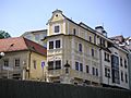
City Sights and Buildings
.jpg)

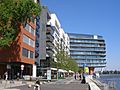
Bratislava's skyline has old towers and grand 20th-century buildings. The city has changed a lot with new construction in the 21st century.
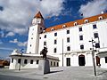
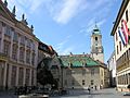
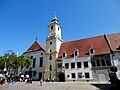
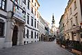
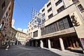
Most historic buildings are in the Old Town. The Bratislava's Town Hall is a group of three buildings from the 14th–15th centuries. It now holds the Bratislava City Museum. Michael's Gate is the only gate left from the old city walls. It is one of the oldest buildings in town.
Many baroque palaces fill the historic center. The Grassalkovich Palace, built around 1760, is now where the Slovak president lives. The Slovak government is in the old Archiepiscopal Palace. In 1805, the Peace of Pressburg was signed in the Primate's Palace.


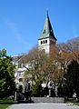
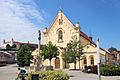
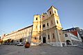
Important churches include the Gothic St. Martin's Cathedral. It was built between the 13th and 16th centuries. It was the church where Hungarian kings and queens were crowned. The Franciscan Church is the oldest church in the city, from the 13th century. The Church of St. Elizabeth, also called the Blue Church, is known for its unique blue color. Bratislava has one synagogue that is still used today.
The Slavín military cemetery was opened in 1960. It honors Soviet soldiers who died freeing Bratislava in 1945. It also offers great views of the city.
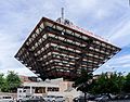
Other famous 20th-century buildings include the Most Slovenského národného povstania (Bridge of the Slovak National Uprising). It has a UFO-shaped restaurant on top. The Slovak Radio building looks like an upside-down pyramid. The Kamzík TV Tower has a viewing deck and a spinning restaurant.
Bratislava Castle
.JPG)
One of the most famous buildings is Bratislava Castle. It sits on a hill 85 meters (279 ft) above the Danube. People have lived on this castle hill since the Stone and Bronze ages. It was a Celtic town, a Roman border post, and a big Slavic settlement. A stone castle was built in the 10th century.
The castle was made stronger in 1430. It became a Renaissance castle in 1562 and was rebuilt in the baroque style in 1649. Under Queen Maria Theresa, it became a fancy royal home. In 1811, a fire accidentally destroyed the castle. It was in ruins until the 1950s when it was rebuilt. Today, it is used for special events and as a historical museum.
Devín Castle
.jpg)

The ruined and now repaired Devín Castle is in the Devín area. It sits on a rock where the Morava River meets the Danube. This river forms the border between Austria and Slovakia. It is a very important place for Slovak history and has a museum. Devín Castle was a key border castle for Great Moravia and early Hungary. Napoleon's troops destroyed it in 1809. It is a strong symbol of Slovak and Slavic history.
Rusovce Area
The Rusovce mansion, with its English park, is in the Rusovce area. The house was built in the 17th century. It was changed into an English neo-Gothic mansion in 1841–1844. This area is also known for the old Roman military camp Gerulata. This camp was part of the Roman border defense system.
Parks and Lakes

Bratislava has many forests close to the city center. This is because it is near the Little Carpathians mountains and the Danube river. The city has 46.8 square kilometers (18.1 sq mi) of public green space. That's about 110 square meters (1,184 sq ft) per person.
The biggest city park is Horský park (Mountainous Park). The Bratislavský lesný park (Bratislava Forest Park) is in the Little Carpathians. It has many popular spots like Železná studienka. The Forest Park covers 27.3 square kilometers (10.5 sq mi). Most of it is forest with oak trees. On the right side of the Danube is Janko Kráľ Park, started in 1774–76.
Bratislava's zoological park is in Mlynská dolina. It has 152 types of animals, including rare white lions. The Botanical Gardens belong to Comenius University. They have over 120 types of plants.
The city has many natural and human-made lakes. Most are used for fun activities. Examples include Štrkovec lake, Kuchajda, Zlaté Piesky, and Rusovce lake.
People of Bratislava

| District | Population | Ethnic group | Population |
|---|---|---|---|
| Bratislava I–V | 475,577 | Slovaks | 407,358 |
| Bratislava I | 46,432 | Hungarians | 11,167 |
| Bratislava II | 112,001 | Czechs | 5,031 |
| Bratislava III | 76,694 | Ukrainians | 1524 |
| Bratislava IV | 105,154 | Germans | 750 |
| Bratislava V | 122,296 | Other/undeclared | 47,239 |
From the city's start until the 1800s, Germans were the main group. By the end of World War I, 42% of people spoke German, 40% Hungarian, and 15% Slovak. After Czechoslovakia was formed in 1918, more Slovaks and Czechs moved to the city. The number of Germans and Hungarians went down.
In 1938, 59% of people were Slovaks or Czechs. Germans were 22% and Hungarians 13%. When the first Slovak Republic was created in 1939, many Czechs had to leave. Many Jewish people were also forced to leave their homes. In 1945, most Germans were moved out. After the war, many Germans and Hungarians living in Bratislava had to leave the city.
Since the 1950s, Slovaks have been the main group in Bratislava. They make up about 90% of the city's population.
Bratislava's Economy

The Bratislava Region is the richest part of Slovakia. It is the smallest region but makes up about 26% of Slovakia's total economy. Bratislava is the 19th richest region in the European Union. The unemployment rate in Bratislava was very low in June 2023, at 2.38%. The average monthly salary in Bratislava in 2024 was €2,101.

Many government offices and private companies have their main offices in Bratislava. More than 75% of people in Bratislava work in the service industry. This includes jobs in trade, banking, IT, and tourism. The Bratislava Stock Exchange was started in 1991.
Big companies in Bratislava include the Volkswagen Bratislava Plant, Slovnaft (an oil refinery), and Eset (a software company).
Volkswagen Group took over a factory in 1991. They now make many different cars there, including Audi Q7 and Volkswagen Touareg.
In recent years, service and high-tech businesses have grown a lot. Many global companies like IBM, Dell, Lenovo, and Amazon have set up offices here. They come because Bratislava is close to Western Europe. It also has many skilled workers and universities. Slovak IT companies like ESET also have their main offices in Bratislava.

Other big companies in Bratislava include Slovak Telekom and Tesco.
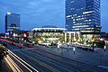
The strong growth of Slovakia's economy in the 2000s led to a building boom in Bratislava. Many new projects have been finished or are planned. These include areas along the Danube riverfront, like River Park and Eurovea.
Visiting Bratislava


In 2022, nearly 928,000 people visited Bratislava. Most of them (65%) were from other countries. Visitors mainly come from nearby countries like the Czech Republic, Germany, Austria, and Poland. The UK is also a top country for visitors. Bratislava had 272 places to stay with over 10,000 rooms in 2022. Many people also visit Bratislava for just one day.
More low-cost flights to Bratislava have made it a popular place for group trips. While this helps tourism, some visitors came for lively parties, which sometimes caused concerns for local officials.
Shopping in Bratislava


Bratislava has eight large shopping centers. These include Aupark, Avion Shopping Park, Bory Mall, Central, Eurovea, Nivy Centrum, Vivo!, and Shopping Palace.
A month before Christmas, the Main Square lights up with a Christmas tree. Christmas market stalls officially open then. About 100 booths are open every year, all day and evening.
Culture in Bratislava
Bratislava is the cultural heart of Slovakia. Its history means its culture is a mix of German, Slovak, Hungarian, and Jewish influences. Bratislava has many theaters, museums, art galleries, and concert halls.
Shows and Performances


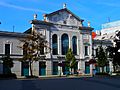
Bratislava is home to the Slovak National Theatre. It has two buildings. The old one is in the Old Town. The new one opened in 2007 by the river. The theater has groups for opera, ballet, and plays. Smaller theaters include the New Scene Theatre and the Arena Theatre.

Music was very important in Bratislava in the 1700s. It was connected to the music scene in Vienna. Mozart visited the city when he was six. Other famous composers like Joseph Haydn and Ludwig van Beethoven also visited. Bratislava is the birthplace of composers like Johann Nepomuk Hummel.
Bratislava is home to the Slovak Philharmonic Orchestra. The city also hosts yearly festivals, like the Bratislava Music Festival. In summer, many music events happen at Bratislava Castle.
Museums and Art Galleries
.jpg)


The Slovak National Museum was founded in 1961. Its main office is in Bratislava. It is the biggest cultural organization in Slovakia. It manages 16 different museums. The Bratislava City Museum is the oldest museum in Slovakia, started in 1868. It tells the story of Bratislava's history.
The Slovak National Gallery has the largest network of galleries in Slovakia. The Bratislava City Gallery is the second largest. The Danubiana Art Museum is one of Europe's newest art museums. It is near the Čunovo waterworks.
News and Media
As the capital, Bratislava is home to many news and media companies. TV stations like Slovak Television and Radio (STVR), Markíza, and JOJ are based here. STVR's radio headquarters is in the city center. Many Slovak newspapers are also based in Bratislava.
Sports in Bratislava

Bratislava has a long history with many sports and teams. Many teams and athletes compete in Slovak and international leagues.
Football is popular. ŠK Slovan Bratislava is the main club in the top Slovak league. They play at the Tehelné pole stadium. ŠK Slovan is the most successful football club in Slovak history. They are the only club from old Czechoslovakia to win a European football competition.
FC Petržalka akadémia is the oldest football club in Bratislava, started in 1898. They are the only Slovak team to win a match in the UEFA Champions League group stage.

Bratislava has three winter sports arenas. The Ondrej Nepela Winter Sports Stadium is home to the HC Slovan Bratislava ice hockey team. Bratislava has hosted the Ice Hockey World Championships several times.
The Čunovo Water Sports Centre is a place for whitewater slalom and rafting. It hosts many international and national canoe and kayak competitions.
The National Tennis Centre, which includes Aegon Arena, hosts many events. Several Davis Cup tennis matches have been played there. The city also has teams in top Slovak leagues for basketball, handball, volleyball, and water polo. The Devín–Bratislava National run is the oldest running event in Slovakia. The Bratislava City Marathon has been held every year since 2006.
Learning and Science


The first university in Bratislava was Universitas Istropolitana. King Matthias Corvinus founded it in 1465. It closed in 1490.
Bratislava is home to the largest university in Slovakia, Comenius University in Bratislava. It has over 27,000 students. The largest technical university, Slovak University of Technology in Bratislava, is also here. It has over 18,000 students. The oldest art schools, the Academy of Performing Arts and the Academy of Fine Arts and Design, are also in Bratislava. In total, about 56,000 students go to university in Bratislava.
There are 65 public primary schools in the city, with over 25,000 students. The city also has many high schools and vocational schools.
The Slovak Academy of Sciences is also based in Bratislava.
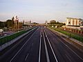
Getting Around Bratislava
.jpg)


Bratislava's location in Central Europe has made it a natural hub for trade and travel.
Public transport in Bratislava is run by a city company. It uses buses, trams, and trolleybuses. Most public transport vehicles are red and black. Bratislava is also part of a system that connects city transport with other companies in the Bratislava region. You can travel with one ticket throughout the whole system.
As a train hub, the city has direct connections to Austria, Hungary, the Czech Republic, and other parts of Slovakia. Bratislava-Petržalka railway station and Bratislava Main station are the main train stations.
Trains and buses run many times every hour from Bratislava to Vienna. This makes it easy to travel to other parts of Europe.
The main bus station, Nivy, is east of the city center. It offers bus connections to cities in Slovakia and other countries. A new underground bus station opened in 2021. It is part of a shopping mall and office center.
Motorways connect Bratislava directly to Brno in the Czech Republic, Vienna in Austria, and Budapest in Hungary. The A6 motorway between Bratislava and Vienna opened in 2007.
The Port of Bratislava is one of two international river ports in Slovakia. It connects to the Black Sea via the Danube. It also connects to the North Sea through a canal. Tourist boats also run from Bratislava to Devín and Vienna.
There are six bridges over the Danube in Bratislava. These include Most Lafranconi, Most SNP (with the UFO Tower), Starý most (The Old Bridge), Most Apollo, Prístavný most (The Harbor Bridge), and Lužný most.
Bratislava's M. R. Štefánik Airport is the main international airport in Slovakia. It is 9 kilometers (5.6 miles) northeast of the city center. It handles flights for people and government, both regular and special. The airport can handle all common types of planes. Bratislava is also served by the Vienna International Airport, which is 49 kilometers (30 miles) west of the city. Many Bratislava residents use the Vienna airport because it offers more flight choices.
.jpg)


International Connections

Sister Cities
Bratislava has special partnerships with these cities:
* The first agreement was signed with the city of Perugia in Italy on July 18, 1962.
Famous People
Honorary Citizens
These people have been given the special honor of being a citizen of Bratislava:
| Date | Name | Notes |
|---|---|---|
| 4 September 1990 | Helmut Zilk | Mayor of Vienna |
| 24 September 1997 | Edita Gruberová | Soprano singer |
| 19 November 2009 | Václav Havel (1936–2011) | Former President of Czechoslovakia and the Czech Republic |
| 26 September 2011 | Major General Roy Martin Umbarger | United States Army Officer |
| 28 October 2014 | Karel Gott | Czech singer |
| 19 December 2020 | John Paul II | Catholic Pope |
Images for kids
-
Main entrance of the Bratislava Castle
-
Hviezdoslav Square
-
Primate's Square
-
The Old Town Hall, the oldest city hall in the country
-
Michael's Gate
-
Laurinc Gate
-
Reformed church
-
Church of Saint Stephen
-
Trinitarian Church
-
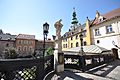
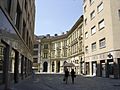
The Old Town of Bratislava
-
Streets of the Old Town
-
Bratislava Old Town
-
The Rococo-style "House of the Good Shepherd", home to the Museum of Clocks
-
Laurinská Street
-
Stará Tržnica Market Hall, the oldest indoor market in Bratislava
-
Einsteinova street
-
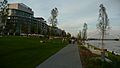
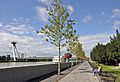
Danube promenade
-
Embankment
-
Danube river and the Slovak National Uprising Bridge
-
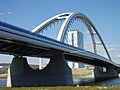
Apollo Bridge
-
VIVO! Shopping Center
-
Slovak Radio headquarters building
-
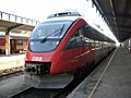
CityShuttle train connects Bratislava with Austria's capital Vienna.
-
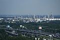
Refinery of Slovnaft in Bratislava
-
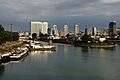
Port of Bratislava
-
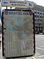
Map of Bratislava in city centre
-
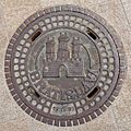
Manhole cover in Bratislava

.jpg)


.jpg)


.jpg)
.jpg)

.jpg)


.jpg)

_2019.jpg)


See also
 In Spanish: Bratislava para niños
