
Tidworth facts for kids
Quick facts for kids Tidworth |
|
|---|---|
 Tidworth Camp: a view over the garrison from Clarendon Hill |
|

Tidworth
|
|
| Population | 12,089 (2021 Census) |
| OS grid reference | SU2348 |
| Unitary authority |
|
| Ceremonial county | |
| Region | |
| Country | England |
| Sovereign state | United Kingdom |
| Post town | TIDWORTH |
| Postcode district | SP9 |
| Dialling code | 01980 |
| Police | Wiltshire |
| Fire | Wiltshire |
| Ambulance | Great Western |
| EU Parliament | South West England |
| UK Parliament |
|
Tidworth is a town in south-east Wiltshire, England. It's known as a military town because it has a large British Army base. Tidworth is on the eastern edge of Salisbury Plain, a big open area used for army training.
The town sits on both sides of the A338 road. It's about 5.6 kilometres (3.5 miles) north of the A303 main road. Tidworth is around 13 kilometres (8 miles) west of Andover and 21 kilometres (13 miles) north-east of Salisbury. In 2011, about 10,600 people lived here.
Tidworth used to be two separate villages: North Tidworth and South Tidworth. Today, the town is mostly shaped by Tidworth Camp, which is a very large British Army site. Another army base, Swinton Barracks, is located in the western part of the town.
Contents
History of Tidworth
Ancient Times
People have lived in the Tidworth area for a very long time. We know this because there are several ancient burial mounds called bowl barrows here. One group has seven of these mounds. There's also an Iron Age hillfort (an old fort on a hill) at Sidbury Hill in the north of the area.
Early Settlements
In 1086, the Domesday Book recorded the villages that would become Tidworth. What is now North Tidworth had four landowners and 18 households. South Tidworth had three landowners, 20 households, and a church. The names were written as Todeworde, Tedorde, or Todeorde.
The two villages grew up in the valley of a small river called the River Bourne. This river flows south to join the Hampshire Avon near Salisbury. Later, a road connecting Oxford and Salisbury also followed this valley.
Changes Over Time
On maps from 1611 by John Speed, the villages were called North Tudworth and South Tudworth. Before 1650, there was a large country house with parkland in South Tidworth. The house you see today, Tedworth House, was rebuilt between 1828 and 1830.
In 1897, the War Office (which manages the army) bought Tedworth House and its land. They also bought land to the north, which gave them access to Salisbury Plain for army training. Many barracks (army buildings) were built in the early 1900s. These were mostly in South Tidworth but also spread into North Tidworth. From 1902 to 1963, North Tidworth even had its own railway station, connected to a main line.
Boundary Changes
North and South Tidworth used to be separate church areas, and then became separate local government areas in the 1800s. An Ordnance Survey map from 1958 still showed them as North Tidworth and South Tedworth.
In 1992, the border between Wiltshire and Hampshire counties was changed. This meant that the whole town of Tidworth became part of Wiltshire. However, it still remained part of the Hampshire postal county for mail. The two parts stayed as separate local government areas until April 1, 2004, when they officially joined to form one town.
In the 2000s, the number of people living in Tidworth grew. This happened because the army barracks, now called Tidworth Camp, got bigger. Many army units moved back from Germany in 2019 and 2020 as part of the Army Basing Plan.
Religious Sites
Holy Trinity Church

Holy Trinity in North Tidworth is the local Church of England parish church. There might have been a church here as early as the 1100s, but the first official record is from 1291. The building you see today was built in the late 1300s and 1400s. It's made of flint and stone, with some repairs done with red brick.
In 1882, the church was restored by J. L. Pearson, who replaced the roofs and rebuilt the porch. In 1988, the church was given a special status as a Grade II* listed building, meaning it's an important historic building.
Inside, the font (a basin for baptisms) is from the 1100s. Three of the six bells were made in 1619, and another in 1700. There are also two old stone tombs from the 1600s in the churchyard.
Other Churches
There was a church called St Mary's in South Tidworth from the 1200s or 1300s. By 1784, it was in bad shape. The owner of Tedworth House, Thomas Assheton Smith the elder, was allowed to pull it down. Some parts of the old church, like a 1300s window and some monuments, were used to build a small chapel. This chapel is still used today as a mortuary chapel for the nearby cemetery.

A new St Mary's Church was built closer to Tedworth House in 1878. It was designed by John Johnson and paid for by Sir John Kelk. This church is a Grade I listed building, which means it's considered very important historically. It is now looked after by the Churches Conservation Trust.
For the soldiers in the garrison, there are two military churches built in 1912: St Michael's Garrison Church (Church of England) and St Patrick's Garrison Church (Roman Catholic).
How Tidworth is Governed
Tidworth has its own town council, which is a group of local people elected to make decisions for the town. The town is also part of the Wiltshire Council unitary authority. This means Wiltshire Council is in charge of most local services, like roads and schools.
Tidworth elects two people to represent it on Wiltshire Council. One represents Tidworth North & West, which includes most of the town and Tidworth Camp. The other represents Tidworth East & Ludgershall South.
For national elections, Tidworth is part of the East Wiltshire area. This area has been represented by Danny Kruger from the Conservatives since 2024.
Things to Do and See in Tidworth
Tidworth has a small shopping area. You can find two supermarkets (a Lidl and a large Tesco), two animal doctors (veterinary surgeries), a pharmacy, and other shops. There's also a dental surgery that helps about 5,000 people in Tidworth and nearby areas. In 2003, a new medical centre was built. The cost was shared by the Ministry of Defence and the NHS, as it helps both military families and local residents.
Castledown FM is a community radio station that broadcasts to Tidworth and Ludgershall. Its studios are at Wellington Academy.
Tidworth is known for being a safe place to live. It has one of the lowest crime rates in Wiltshire. In 2014, the Royal Mail even said it was the most attractive place to live in England based on its postcode area.
Tidworth Garrison Golf Club was built in 1904 for army officers. It became a proper club in 1908 and slowly opened up to all soldiers and civilians. In 2000, it became a limited company.
Tidworth Polo Club, also called Tedworth Park Polo Club, is south of Tedworth House. It's a key place for the British Army Polo Association.
South of Tidworth, there's a place for downhill mountain biking. Local mountain bikers secretly built it in 2006. Later, a company called B1KE took it over and now runs it as a business. It has trails for all skill levels.
Education
The Wellington Academy is a secondary school in Tidworth. It opened in September 2009 and replaced Castledown School. The academy has a sixth form college for older students, a sports pitch that can be used in any weather, and special facilities for the Combined Cadet Force (CCF). The CCF is a program that teaches young people about the military. The local army unit that supports the CCF is the 26 Royal Engineers, based at Swinton Barracks.
The community also has three primary schools and one infant school for younger children.
Media
Local news and TV shows for Tidworth come from BBC South and ITV Meridian. TV signals are received from the Hannington and local relay transmitters.
Local radio stations include BBC Radio Wiltshire on 103.5 FM and Greatest Hits Radio Salisbury on 102 FM. The British Forces Broadcasting Service (BFBS) also provides radio programs for the military on Salisbury Plain on 106.8 FM.
The local newspapers that cover Tidworth are the Salisbury Journal and the Andover Advertiser.
Famous People from Tidworth
- Duggie Fields, an artist, was born in Tidworth.
- The musician James Blunt was born in Tidworth in 1974.
Some important people who owned the South Tidworth estate and Tedworth House include:
- John Smith (1656–1723), who was a Speaker of the House of Commons and a Chancellor of the Exchequer.
- Thomas Assheton Smith (1752–1828), who owned the Dinorwic quarry and was a Member of Parliament (MP).
- His son Thomas (1776–1858), who was a cricketer, foxhunter, yacht designer, and MP. He was the one who built the current Tedworth House.
Images for kids
-
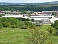
Tidworth Camp: a view over the garrison from Clarendon Hill
-
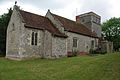
Holy Trinity, North Tidworth
-
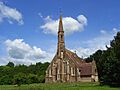
St Mary's Church, South Tidworth
See also
 In Spanish: Tidworth para niños
