Toombs County, Georgia facts for kids
Quick facts for kids
Toombs County
|
|
|---|---|

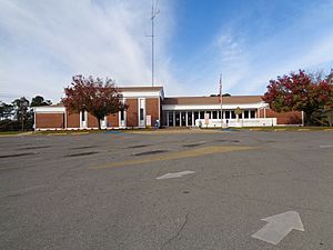
Former Toombs County Courthouse in Lyons
|
|

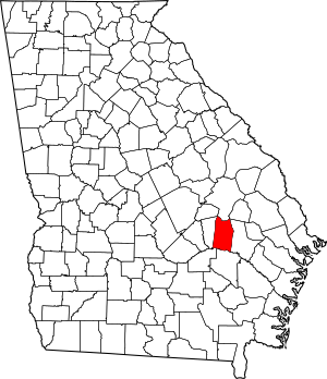
Location within the U.S. state of Georgia
|
|
 Georgia's location within the U.S. |
|
| Country | |
| State | |
| Founded | August 18, 1905 |
| Named for | Robert Toombs |
| Seat | Lyons |
| Largest city | Vidalia |
| Area | |
| • Total | 371 sq mi (960 km2) |
| • Land | 364 sq mi (940 km2) |
| • Water | 7.0 sq mi (18 km2) 1.9%% |
| Population
(2020)
|
|
| • Total | 27,030 |
| • Density | 74/sq mi (29/km2) |
| Time zone | UTC−5 (Eastern) |
| • Summer (DST) | UTC−4 (EDT) |
| Congressional district | 12th |
Toombs County is a county located in the eastern part of Georgia. In 2020, about 27,030 people lived here. The main town, called the county seat, is Lyons. The biggest city in the county is Vidalia. Toombs County was created on August 18, 1905. It is also part of the Vidalia area, which is a group of towns connected by jobs and daily life.
Contents
History of Toombs County
Toombs County became the 144th county in Georgia. The State Legislature officially created it on August 18, 1905. The county started with parts of Tattnall and Montgomery Counties. Later, in 1907, a small piece of Emanuel County was added. This addition gave Toombs County the borders it has today.
The county is named after Robert Toombs. He was an important person in American history. Robert Toombs served as a representative and a senator for the United States. During the Civil War, he was a leader in the Confederate government and a general in their army.
Geography and Nature
Toombs County covers a total area of about 371 square miles. Most of this area, about 364 square miles, is land. The remaining 7 square miles, which is about 1.9% of the county, is water.
The southern part of Toombs County is special. It is located in the Altamaha River area. This river basin is a large region where water drains into the Altamaha River. The northern part of the county is in the Ohoopee River area. The Ohoopee River is another important waterway that flows into the Altamaha River.
Main Roads in Toombs County
Many important roads run through Toombs County. These roads help people travel and transport goods. They connect the county to other parts of Georgia and beyond.
 U.S. Route 1
 U.S. Route 280
 State Route 4
 State Route 15
 State Route 29
 State Route 30
- 20px State Route 56
 State Route 86
 State Route 130
 State Route 147
 State Route 152
 State Route 178
 State Route 292
 State Route 297
 State Route 298
Neighboring Counties
Toombs County shares its borders with several other counties. Knowing these helps understand its location in Georgia.
- Emanuel County (to the north)
- Tattnall County (to the east)
- Appling County (to the south)
- Jeff Davis County (to the southwest)
- Montgomery County (to the west)
- Treutlen County (to the northwest)
- Candler County (to the northeast)
Towns and Places
Toombs County has several towns and one special area. These are the places where people live and work.
Cities
- Lyons (the county seat)
- Santa Claus
- Vidalia (the largest city)
Census-Designated Place
- Ohoopee (a community identified for census purposes)
Population and People
The number of people living in Toombs County has changed over the years. Here's a look at the population from past records.
| Historical population | |||
|---|---|---|---|
| Census | Pop. | %± | |
| 1910 | 11,206 | — | |
| 1920 | 13,897 | 24.0% | |
| 1930 | 17,165 | 23.5% | |
| 1940 | 16,952 | −1.2% | |
| 1950 | 17,382 | 2.5% | |
| 1960 | 16,837 | −3.1% | |
| 1970 | 19,151 | 13.7% | |
| 1980 | 22,592 | 18.0% | |
| 1990 | 24,072 | 6.6% | |
| 2000 | 26,067 | 8.3% | |
| 2010 | 27,223 | 4.4% | |
| 2020 | 27,030 | −0.7% | |
| 2023 (est.) | 27,040 | −0.7% | |
| U.S. Decennial Census 1790-1880 1890-1910 1920-1930 1930-1940 1940-1950 1960-1980 1980-2000 2010 |
|||
People Living in Toombs County (2020)
In 2020, the census counted 27,030 people living in Toombs County. These people lived in about 10,030 households. Here's a breakdown of the different groups of people living in the county:
| Group | Number | Percentage |
|---|---|---|
| White (not Hispanic) | 16,007 | 59.22% |
| Black or African American (not Hispanic) | 6,980 | 25.82% |
| Native American | 31 | 0.11% |
| Asian | 207 | 0.77% |
| Pacific Islander | 6 | 0.02% |
| Other/Mixed | 755 | 2.79% |
| Hispanic or Latino | 3,044 | 11.26% |
Famous People from Toombs County
Many talented individuals have come from Toombs County. They have made a name for themselves in sports, music, business, and other fields.
- Mel Blount (a football hall of famer and founder of Mel Blount Youth Home)
- Nick Eason (a former NFL player and current NFL assistant defensive line coach)
- Craig Campbell (a country music singer)
- Fred Stokes (a former professional football player)
- Travares Tillman (a professional football player)
- Don Collins (a former professional baseball player)
- Paul Claxton (a professional golfer on the PGA tour)
- Wally Moses (a former professional baseball player)
- Algur H. Meadows (a successful oilman and businessman)
- Iris Blitch (a politician)
- Carl Simpson (a former professional baseball player)
- Don Harris (a journalist)
- Ben Utt (a professional football player)
- Paul Anderson (known as one of the strongest men in the world)
See also
 In Spanish: Condado de Toombs para niños

