Towns County, Georgia facts for kids
Quick facts for kids
Towns County
|
|
|---|---|

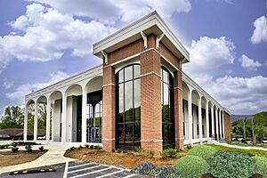
Towns County Courthouse in Hiawassee
|
|

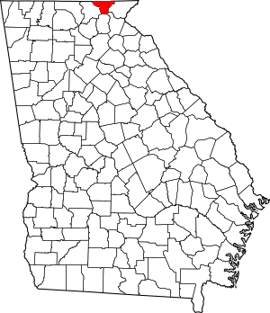
Location within the U.S. state of Georgia
|
|
 Georgia's location within the U.S. |
|
| Country | |
| State | |
| Founded | 1856 |
| Named for | George W. Towns |
| Seat | Hiawassee |
| Largest city | Young Harris |
| Area | |
| • Total | 172 sq mi (450 km2) |
| • Land | 167 sq mi (430 km2) |
| • Water | 5.4 sq mi (14 km2) 3.2%% |
| Population
(2020)
|
|
| • Total | 12,493 |
| • Density | 75/sq mi (29/km2) |
| Time zone | UTC−5 (Eastern) |
| • Summer (DST) | UTC−4 (EDT) |
| Congressional district | 9th |
Towns County is a county located in the Northeast part of the U.S. state of Georgia. In 2020, about 12,493 people lived there. The main town and county seat is Hiawassee. Towns County was created on March 6, 1856. It was named after George W. Towns, who was a lawyer, lawmaker, and politician.
Contents
History of Towns County
Long ago, a special road called the Unicoi Turnpike went through Towns County. This road was an old Cherokee trading path. It helped people travel north and south through the county, passing through Unicoi Gap.
For many years, this road was a border between European-American settlers and the Cherokee people. After the 1830s, when Native American lands were taken and people were moved, the road became fully controlled by white settlers.
During the Indian Removal period, Cherokee people were forced to leave their homes. They were temporarily held in "removal forts." One of these forts was built in what is now Hiawassee. From there, they were made to travel a long, sad journey known as the Trail of Tears to new lands west of the Mississippi River.
In the early 1700s, animal skins like deerskins and furs were sent along the Unicoi Turnpike. They went from Tennessee to cities like Savannah and Charleston. From these cities, the furs were shipped to Europe. Between 1807 and 1811, a special factory for fur trading was built in modern-day Hiawassee by the United States government.
White settlers started living in Hiawassee around 1820. In 1856, it became the main town for the new Towns County. Hiawassee officially became a town in 1870 and a city in 1916.
Young Harris College was started in 1886. The old Towns County Jail was built in downtown Hiawassee around 1935. This two-story stone building is now a special historic place. Blue Ridge Mountain EMC, an electric company, was founded in Young Harris in 1937.
Lake Chatuge is a lake made by people. It was created when the Chatuge Dam was finished in 1942 by the Tennessee Valley Authority. In July 1980, President Jimmy Carter visited Towns County. He landed by helicopter to go fishing for trout with his friends.
The Brasstown Valley Resort was built in 1995. It cost $27 million and is located on 503 acres east of Young Harris. The Fieldstone Inn opened in June 1987 on the shore of Lake Chatuge. The movie Trouble with the Curve, starring Clint Eastwood, was partly filmed in Towns County in 2012. A special "moon tree" was planted in Towns County in 2024.
Geography of Towns County
Towns County covers about 172 square miles. About 167 square miles of this is land, and 5.4 square miles (which is 3.2%) is water.
Most of Towns County is in the Hiwassee River area, which is part of the larger Middle Tennessee-Hiwassee basin. A small part of the county is in the Tugaloo River area, which is part of the Savannah River basin. A tiny bit of the county's southwest corner is in the Chattahoochee River area. This is near where the Chattahoochee River starts in Union County.
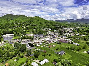
Towns County is located among the Blue Ridge Mountains. These mountains are part of the larger Appalachian Mountains. Some parts of these mountains are protected within the Chattahoochee National Forest. Brasstown Bald, which is the highest mountain in Georgia, is partly in southwest Towns County and partly in Union County.
The Hiwassee River begins in eastern Towns County and flows north into North Carolina. Chatuge Lake is a very important lake in the northeastern part of Towns County. It also goes into North Carolina. It is the highest major lake in Georgia. State Route 515, a highway from north of Atlanta, ends here at the North Carolina state line near Young Harris.
Main Roads
Nearby Counties
- Clay County, North Carolina (north)
- Rabun County (east)
- Habersham County (southeast)
- White County (south)
- Union County (west)
Protected Natural Areas
- Appalachian Trail (part of it)
- Chattahoochee National Forest (part of it)
Population of Towns County
| Historical population | |||
|---|---|---|---|
| Census | Pop. | %± | |
| 1860 | 2,459 | — | |
| 1870 | 2,780 | 13.1% | |
| 1880 | 3,261 | 17.3% | |
| 1890 | 4,064 | 24.6% | |
| 1900 | 4,748 | 16.8% | |
| 1910 | 3,932 | −17.2% | |
| 1920 | 3,937 | 0.1% | |
| 1930 | 4,346 | 10.4% | |
| 1940 | 4,925 | 13.3% | |
| 1950 | 4,803 | −2.5% | |
| 1960 | 4,538 | −5.5% | |
| 1970 | 4,565 | 0.6% | |
| 1980 | 5,638 | 23.5% | |
| 1990 | 6,754 | 19.8% | |
| 2000 | 9,319 | 38.0% | |
| 2010 | 10,471 | 12.4% | |
| 2020 | 12,493 | 19.3% | |
| 2023 (est.) | 13,035 | 24.5% | |
| U.S. Decennial Census 1790-1880 1890-1910 1920-1930 1930-1940 1940-1950 1960-1980 1980-2000 2010 |
|||
2020 Census Information
| Race | Num. | Perc. |
|---|---|---|
| White (not Hispanic) | 11,469 | 91.8% |
| Black or African American (not Hispanic) | 124 | 0.99% |
| Native American | 28 | 0.22% |
| Asian | 81 | 0.65% |
| Pacific Islander | 3 | 0.02% |
| Other/Mixed | 373 | 2.99% |
| Hispanic or Latino | 415 | 3.32% |
In 2020, there were 12,493 people living in Towns County. There were 4,898 households and 3,240 families.
2010 Census Information
In 2010, there were 10,471 people living in the county. Most people were white (97.7%). Other groups included black or African American (0.4%), Asian (0.4%), and American Indian (0.3%). About 2.0% of the people were of Hispanic or Latino background.
The average age of people in Towns County was 51.1 years. The average income for a family was $48,020. About 9.3% of the people lived below the poverty line. This included 13.2% of those under 18 years old.
Education in Towns County
Towns County School District
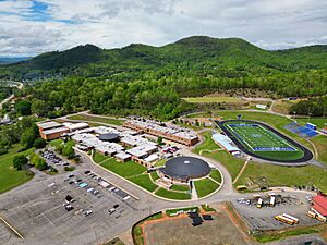
The Towns County School District teaches students from pre-school all the way to twelfth grade. All the public schools are on one campus east of Hiawassee. This includes an elementary school, a middle school, and a high school. The district has over 2,408 students and 144 full-time teachers.
- Towns County Elementary School
- Towns County Middle School
- Towns County High School
Young Harris College
For higher education, students can go to Young Harris College in Young Harris. This is a private college that is connected to the Methodist church. It was started in 1886. In 2020, about 1,425 students were studying there. The college offers degrees in more than 30 main subjects and 22 smaller subjects.
Media in Towns County
The Towns County Herald is a newspaper that has been published every week in Hiawassee since 1928. Before that, a newspaper called The Young Harris News was first published around 1900.
Towns County Communities
Cities
Census-Designated Place
Famous People from Towns County
- Zell Miller – He was a former governor of Georgia and a U.S. senator.
Images for kids
See also
 In Spanish: Condado de Towns para niños
 | Aaron Henry |
 | T. R. M. Howard |
 | Jesse Jackson |


