
Trans-Asian Railway facts for kids
The Trans-Asian Railway (TAR) is a big plan to connect Europe and Asia with a network of train tracks. It's like building a super-highway for trains! The United Nations (UN) started this project. It's managed by their group called the Economic and Social Commission for Asia and the Pacific (UNESCAP).
This idea began way back in the 1950s. The first goal was to create a 8,750-mile (14,000 km) train link. It would stretch all the way from Singapore to Istanbul, Turkey. They even thought about connecting it to Europe and Africa.
Back then, there weren't as many ships or planes for moving goods. So, this train project promised to make shipping faster and cheaper. But, political and money problems slowed it down for many years. By the 1990s, after the Cold War, countries started getting along better. This made the idea of a rail network across Asia seem possible again.
Contents
Why the Trans-Asian Railway is Important
The TAR project was seen as a way to handle the huge increase in trade between countries in Europe and Asia. It would make shipping goods much easier.
It was also a way to help countries that are landlocked. These are countries like Laos, Afghanistan, Mongolia, and the Central Asian republics. They don't have a coastline. The railway would make it easier for them to trade and connect with the rest of the world. This would help their economies grow.
Challenges: Different Train Tracks
Most of the railway network for the TAR already exists. But there are still some big gaps. A major challenge is that different countries use different track widths. This is the distance between the two rails.
There are four main track widths across Asia:
- Most of Europe, Turkey, Iran, China, and the Koreas use the 1435 mm width. This is called Standard gauge.
- Finland, Russia, and countries that used to be part of the Soviet Union use a 1520 mm width.
- Most railways in India, Pakistan, Bangladesh, and Sri Lanka use a 1676 mm width.
- Most of Southeast Asia uses a 1000 mm width, called metre-gauge.
The TAR plan doesn't usually change these national track widths. Instead, large machines will be built. These machines will move shipping containers from one train to another at places where the track width changes.
Main Routes of the Railway
By 2001, experts had studied four main routes for the Trans-Asian Railway. These routes are called corridors.
The Northern Corridor
This route will connect Europe and the Pacific Ocean. It goes through Germany, Poland, Belarus, Russia, Kazakhstan, Mongolia, China, and the Koreas.
The track width changes at these borders:
- Polish-Belarusian border (from 1435 mm to 1520 mm)
- Kazakhstan-Chinese border (from 1520 mm to 1435 mm)
- Mongolian-Chinese border (from 1520 mm to 1435 mm)
The 5,750-mile (9,200 km) Trans-Siberian Railway covers much of this route. It already carries many goods from East Asia to Moscow and then to Europe. Because of political issues with North Korea, goods from South Korea must be shipped by sea to the port of Vladivostok to join this route.
The Southern Corridor
This route will go from Europe to Southeast Asia. It connects Turkey, Iran, Pakistan, India, Bangladesh, Myanmar, and Thailand. It also has links to China's Yunnan Province and, through Malaysia, to Singapore.
There are still some missing sections of track:
- In eastern Iran
- Between India and Myanmar
- Between Myanmar and Thailand
- Between Thailand and Cambodia
- Between Cambodia and Vietnam
- Between Thailand and Yunnan
The track width changes at these borders:
- Iran-Pakistan border (from 1435 mm to 1676 mm)
- India-Myanmar border (from 1676 mm to 1000 mm)
- To China (from 1000 mm to 1435 mm)
The Southeast Asian Network
This part of the plan focuses on connecting countries within Southeast Asia.
The North-South Corridor
This route will link Northern Europe to the Persian Gulf. The main path starts in Helsinki, Finland. It continues through Russia to the Caspian Sea.
At the Caspian Sea, it splits into three routes:
- A western route through Azerbaijan, Armenia, and western Iran.
- A central route that crosses the Caspian Sea to Iran by ferry.
- An eastern route through Kazakhstan, Uzbekistan, and Turkmenistan to eastern Iran.
All these routes meet in the Iranian capital of Tehran. From there, they continue to the Iranian port of Bandar Abbas.
Related pages
- Asian Highway Network
Images for kids
-
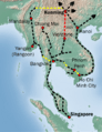
Connections in southeast Asia, built (black) and projected (yellow).

See also
 In Spanish: Ferrocarril transasiático para niños
