Transport on the Gold Coast, Queensland facts for kids
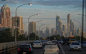
The Gold Coast is a big and fast-growing city in Australia. Because of this, it has many ways to get around. You can use cars, bikes, buses, trains, and even a light rail system. Most people use cars, and the city has a large road network to connect all the suburbs.
The Queensland Government helps manage public transport on the Gold Coast. A group called Translink helps plan how all the different types of transport work together in the wider South East Queensland area.
Contents
Walking and Cycling Around the Gold Coast
Moving Actively
The Gold Coast has programs to help people choose ways to travel that are good for the environment and for them. These programs encourage walking and cycling. They want people to enjoy their journey and avoid traffic jams.
Walking Paths
The Gold Coast has many paths for walking. One famous path is the Gold Coast Oceanway. It's a long path, about 36 kilometres (22 miles) long, that runs along the coast. Many people who live or visit here like to walk to the beach, shops, or other nearby places, especially in busy areas.
The Gold Coast hinterland also has beautiful walking tracks. These are in the Lamington National Park, which is a World Heritage site. The park has over 160 kilometres (100 miles) of walking tracks. These tracks were developed a long time ago by people like Romeo Lahey and Arthur Groom.
Cycling Routes
The Gold Coast is mostly flat, which makes it great for cycling. Many main roads have special lanes just for bikes. There are also paths along rivers that connect the coastal paths to the hinterland. A new bike route, called the V1, is being built along the M1 motorway. It will eventually go all the way from Smith Street to the New South Wales border.
The Gold Coast City Council is working to make cycling easier. They have a bike-sharing program. This lets people borrow a bike from almost anywhere and ride it to their destination. You don't have to return it to a special station, but there are preferred parking areas for bikes.
Roads for Cars and Trucks
Most people on the Gold Coast use private cars. This means the city has a very large road network for an Australian regional city. Different levels of government help manage these roads.
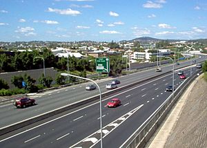
The Australian Federal Government looks after the Pacific Motorway (M1). This is the city's main highway and an important route for moving goods across the country. It starts in Brisbane and goes south through the Gold Coast, continuing into New South Wales.
The Department of Transport and Main Roads, which is part of the Queensland Government, manages state roads. These roads connect the Pacific Motorway to major towns and areas on the Gold Coast.
The Gold Coast City Council looks after all the smaller, local roads in the suburbs.
Public Transport Options
The Gold Coast has a public transport system that includes trains, buses, light rail, and ferries.
Translink is a group that plans and organises public transport in South East Queensland. They make sure all the services, like trains, buses, and light rail, work together. They also manage tickets and zones. You can use a go card to pay for your travel, which is cheaper than paper tickets.
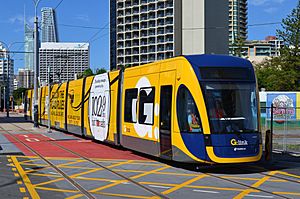
Trains are run by Queensland Rail. Their Citytrain services run on the Gold Coast railway line from Varsity Lakes on the Gold Coast all the way to Brisbane Airport. The light rail, called G:link, runs for 20 kilometres (12 miles) from Broadbeach South to Helensvale. It goes through popular areas like Surfers Paradise and Southport. Buses are run by Kinetic Group and cover most of the city with many routes.
The Gold Coast's public transport system is getting better. More people are using it, especially with new light rail lines and better bus services.
Ferries on the Water
The newest public transport option is Hopo Ferries. This ferry service stops at five popular places: Surfers Paradise, Home of the Arts (HOTA), Marina Mirage, Broadwater Parklands, and Sea World. It runs every day and connects with some Gold Coast light rail stops.
Buses Around Town
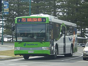
Kinetic Group runs the bus services on the Gold Coast. Translink sets the timetables and manages the tickets. Buses usually run from early morning until midnight, with some services running 24 hours on Friday and Saturday nights.
Trains for Longer Journeys
Heavy Rail Trains
The Gold Coast is connected to Brisbane by the Gold Coast railway line. These trains are part of Brisbane's CityTrain network. They run from Central Station in Brisbane to Varsity Lakes railway station on the Gold Coast. The journey takes about 100 minutes. The train line mostly runs next to the Pacific Motorway. More sections of the line have been added over the years to make travel easier.
Light Rail Trams
The Gold Coast is growing very fast, and more people are travelling. To help with traffic, the city built the G:link light rail system. It opened in 2014 and is 20 kilometres (12 miles) long. It connects areas like Broadbeach, Surfers Paradise, Main Beach, Southport, Parkwood, and Helensvale. The trams run very often, every 8 minutes during busy times and every 15 minutes at other times on weekdays. On weekends, they run every 10 minutes. This system helps reduce traffic and pollution.
The Gold Coast City Council is planning to extend the light rail south to Burleigh Heads. This extension would be about 6.6 kilometres (4.1 miles) long and would add eight new stations. It is planned to be built in the middle of the Gold Coast Highway.
Main Transport Hubs
The Gold Coast has several main places where you can change between different types of transport, like light rail, buses, and trains.
Some of these important hubs include:
- Tweed Mall Shopping Centre: In Tweed Heads, connects to bus services.
- Varsity Lakes railway station: Connects to the Gold Coast train line and buses to southern suburbs.
- Broadbeach South: Connects G:link light rail and buses to western and southern suburbs.
- Robina Railway station: Connects trains and buses to eastern suburbs.
- Nerang Railway station: Connects trains and buses to eastern suburbs.
- Southport: Connects G:link and buses in the city centre.
- Helensvale: This is a special place where you can connect between trains, buses, and the light rail.
- Ormeau railway station: Connects buses to northern Gold Coast suburbs and the City of Logan.
Airports Near the Gold Coast
The Gold Coast is close to Brisbane, so it has two international airports that serve the city.
Gold Coast Airport
The Gold Coast Airport handles flights to places within Australia and other countries. It serves the Gold Coast and the Northern Rivers area of New South Wales. The airport's entrance is in Bilinga, but the runway crosses the border between Queensland and New South Wales. The airport always uses Queensland time.
The Gold Coast Airport is one of the busiest airports in Australia, especially for a city that isn't a state capital. Many people travel through it each year.
Brisbane Airport
Brisbane Airport is the main airport for flights within Australia and to other countries in South East Queensland. It's in Brisbane, about an hour's drive from the Gold Coast city centre in Southport. Many airlines fly from Brisbane Airport to lots of different places.
Brisbane Airport has two train stations. You can catch a train from the airport to Brisbane city, and some trains continue all the way to the Gold Coast, ending at Varsity Lakes.
A Look Back in Time: Old Transport
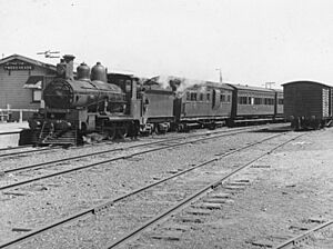
A long time ago, there was a train line called the South Coast Railway Line. It connected the Gold Coast towns to Brisbane. The line reached Southport in 1889. Later, in 1903, it was extended even further south to Tweed Heads on the New South Wales border. This line had stations in many towns like Nerang and Coolangatta.
People could travel by train from South Brisbane to Southport, and then connect to trains going to Tweed Heads. On Sundays, special picnic trains would run all the way from South Brisbane to Tweed Heads.
In the 1950s, more people started using cars. Because of this, the train line to Tweed Heads closed in 1961, and the line to Southport closed in 1964. For over 30 years, the closest train station for the Gold Coast was in Beenleigh. But then, a new train line, the Gold Coast railway line, was built next to the Pacific Motorway. The first part of this new line opened to Helensvale in 1996, giving the Gold Coast a train connection to Brisbane again.
Future Transport Plans
The Gold Coast is still growing very fast, and this means more traffic. The different levels of government in Australia are working on ways to reduce traffic and make travel quicker.
Pacific Motorway Upgrades
The Pacific Motorway is one of Australia's busiest highways. Many thousands of vehicles use the Gold Coast section every day, and this number is expected to grow. The Queensland State Government and the Australian Federal Government are working together to make the motorway bigger.
Mudgeeraba to Varsity Lakes
They are currently making a 5.7-kilometre (3.5-mile) section of the motorway wider, from two lanes to three lanes in each direction. This section is between Mudgeeraba and Varsity Lakes.
Varsity Lakes to Tugun
Plans are also being made to widen and upgrade the motorway between Varsity Lakes and Tugun. This will be a very big and expensive project.
Gold Coast Light Rail Extensions
There is a lot of support for extending the G:link light rail system further south, possibly all the way to the Gold Coast Airport.
Stage 3A – Burleigh Heads Extension
A plan is being made to extend the light rail from Broadbeach South to Burleigh Heads. This would add about 6.6 kilometres (4.1 miles) and eight new stations. The line would run in the middle of the Gold Coast Highway. The Queensland Government and the City of Gold Coast are working together to study the costs and options for this extension.
Stage 3B – Gold Coast Airport Extension
The Gold Coast City Council asked people what they thought about extending the light rail. Many people supported extending it to Burleigh Heads and then even further to the airport.
The council's transport plan for 2031 supports a future extension to the airport. This would be a 14-kilometre (8.7-mile) extension from the planned Burleigh Heads station. It would go south along the Gold Coast Highway, through Palm Beach and Tugun, and end at the Airport.
Heavy Rail Extensions
There have been many ideas over the years to extend the train line from Varsity Lakes to the Gold Coast Airport. The Queensland Government has done planning for this extension. The first part of the extension to Varsity Lakes was finished in 2009. However, the next part has faced some challenges and budget issues. The Queensland Government still plans to extend the line with new stations at Tallebudgera, Elanora, Tugun, and the Gold Coast Airport. However, construction is not likely to start until after a big train project in Brisbane, called Cross River Rail, is finished.
 | Chris Smalls |
 | Fred Hampton |
 | Ralph Abernathy |


