G:link facts for kids
Quick facts for kids G:link |
|
|---|---|
 GCLR Set 9 at Broadwater Parklands 2014-09-28.jpg |
|
| Info | |
| Owner | Translink |
| Locale | Gold Coast, Queensland, Australia |
| Transit type | Light rail |
| Number of lines | 1 |
| Number of stations | 19 (27 after stage 3 completion) |
| Chief executive | Phil Mumford |
| Headquarters | Southport |
| Website | www.ridetheg.com.au |
| Operation | |
| Began operation | 20 July 2014 |
| Operator(s) | Keolis Downer |
| Number of vehicles | 23 Bombardier/Alstom Flexity 2 trams |
| Train length | 43.5 m (143 ft) |
| Headway | 7–30 minutes |
| Technical | |
| System length | 20 km (12 mi) (26 km (16 mi) after stage 3 completion) |
| Track gauge | 1,435 mm (4 ft 8 1⁄2 in) standard gauge |
| Electrification | 750 V DC overhead catenary |
| Average speed | 27 km/h (17 mph) |
| Top speed | 70 km/h (43 mph) |
G:link, also known as the Gold Coast Light Rail, is a modern tram system. It helps people travel around the Gold Coast in Queensland, Australia. It's the only light rail system in Queensland.
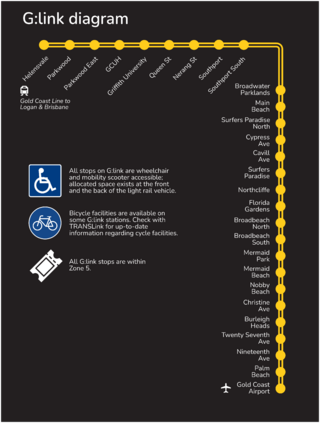
G:link is part of Translink's public transport network. It has one line that is 20 km (12 mi) long. There are nineteen stations along the line. The tram travels from Helensvale railway station in the north to Broadbeach South in the south. The first part of the line opened on 20 July 2014. It was later extended to Helensvale on 17 December 2017.
Contents
How G:link Started
The Gold Coast is a very fast-growing area in Australia. Its population grows by 2–3% each year. Because of this growth, a new transport system was needed. The idea for the Gold Coast Light Rail was first suggested in 1996.
In 2002, the Queensland and Federal Governments helped fund a study. This study looked into how a light rail system could work. A report with the main findings was released in 2004.
Building Stage 1
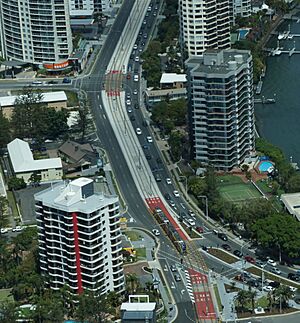
In 2009, the Queensland Government promised $464 million for the project. The Federal Government added $365 million, and the Gold Coast City Council gave $120 million.
In June 2011, a group called GoldLinq won the contract. This group included companies like Bombardier Transportation and Keolis. They were chosen to build and run the light rail line for 18 years.
The first 13 km (8.1 mi) section was estimated to cost $1.6 billion in 2012. Construction started in July 2010 at the Gold Coast University Hospital station. Roadwork began in Broadbeach and Southport in late 2010.
By November 2013, most of the work was finished. Testing of the northern part of the line began in October 2013. The G:link officially opened on 20 July 2014. On opening day, people could ride for free. Regular services started the next day.
Building Stage 2
After Stage 1 was successful, the Queensland Government announced plans in February 2016. They wanted to extend the line from the University Hospital to the Helensvale railway station. This would connect the tram to the Gold Coast railway line, which goes to Brisbane.
The state and federal governments agreed on funding in late 2016. This new extension added 7.3 km (4.5 mi) of tracks and 3 new stations. Helensvale became the new northern end of the line. Construction started in 2016. The goal was to finish before the 2018 Gold Coast Commonwealth Games. The work finished early, and passenger services began in December 2017.
Future Plans
Stage 3 Extension
The Queensland Government, Gold Coast City Council, and the federal government plan to extend the line south. This extension will be 6.4 km (4.0 mi) long. It will go from the current Broadbeach South station to Burleigh Heads.
Construction officially began in July 2022. This involved upgrading water, sewerage, and gas pipes. Major construction, like building tracks, started in 2023. This part of the line is expected to be ready for use by 2026.
New Stations for Stage 3
There will be 8 new stations in Stage 3. They will look similar to the first two stages. All these stations will have a central platform. This means both directions of travel will use platforms in the middle, with tracks on either side. They will have safe pedestrian crossings and be wheelchair accessible. Construction is expected to be completed by 2030.
- Mermaid Beach station is near Crescent Avenue and Montana Road. It's close to shops, restaurants, parks, and a medical centre.
- Mermaid Beach South station is south of Markeri Street. It's near holiday places, shops, and homes.
- Nobby Beach station is between Albicore Street and Dolphin Avenue. It serves the Nobby Beach shopping area and is a short walk to the beach.
- Miami North station is at Paradise Avenue. It serves northern Miami and Miami State High School.
- Miami station is at Hythe Street. It's near Miami Beach and holiday resorts.
- Christine Avenue station is on the southern side of Miami. It's close to shops, restaurants, and North Burleigh Surf Beach.
- Second Avenue Burleigh station is just north of Burleigh Heads. It's near holiday resorts and Burleigh Heads State School.
- Burleigh Heads station will be the southern end of the line. It's near shops, restaurants, parks, and Burleigh Heads Surf Beach. You can also connect to buses here for Varsity Lakes railway station and the Gold Coast Airport.
Stage 3 Route
The new extension will start from Broadbeach South. It will travel south along the middle of the Gold Coast Highway. It will pass through Mermaid Beach, Nobby's Beach, Miami, and Burleigh Heads. This 6.7 km (4.2 mi) extension aims to make travel easier and reduce traffic.
Stage 4 Extension
The Gold Coast City Transport Strategy 2031 plans for a future extension to Coolangatta. This would go via the Gold Coast Airport. This 14 km (8.7 mi) extension would continue south from Burleigh Heads station. It would pass through Palm Beach and Tugun. This would connect the city's international airport to the light rail.
Since 2021, discussions with the community and early work have started for Stage 4.
Where G:link Goes
The single 20-kilometre (12 mi) line runs from Helensvale railway station to Broadbeach South.
Starting at Helensvale, the line runs next to the Gold Coast railway line. It then follows the Smith Street Motorway, stopping at Parkwood and Parkwood East. The next two stops serve the Gold Coast University Hospital and Griffith University.
The line then goes south, crossing the Smith Street Motorway. It reaches Queen Street and Nerang Street stations in Southport. The next two stops serve the Australia Fair Shopping Centre. The following stop is for the Broadwater Parklands.
The tram crosses the Nerang River to reach Main Beach station, near Sea World. Then come Surfers Paradise North and Cypress Avenue. Cypress Avenue is near the Chevron Renaissance Shopping Centre. The next stop, Cavill Avenue, is in the heart of Surfers Paradise.
The following station serves the Q1 residential tower and SkyPoint. The last stops are Northcliffe, Florida Gardens, and Broadbeach North. Broadbeach North is near the Gold Coast Convention & Exhibition Centre and The Star Gold Coast. The line ends at Broadbeach South. This station is near Pacific Fair Shopping Centre and offers bus connections.
It takes about 44 minutes to travel from one end of the line to the other.
There are nineteen stations on the line. Most stations are at street level with open-air platforms. The Gold Coast University Hospital station is underground. Many stations offer transfers to bus services. Helensvale also connects to train services. Two stations have free parking lots. Cavill Avenue is the busiest station.
The Trams
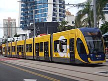
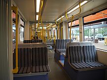
The G:link uses 23 Bombardier Flexity 2 trams. These trams were built in Germany and Austria. They have low floors, making them easy to get on and off. They also have special spaces for wheelchairs, prams, and even surfboards!
The trams can travel up to 70 km/h (43 mph). Each tram can carry 309 passengers, with seats for 80 people. Fourteen trams were ordered for the first part of the line. Four more were added for the Helensvale extension. Five more trams were delivered from July 2023 and started service in July 2024.
How the System Works
The G:link system mainly runs in the middle of the road. It uses standard gauge tracks. The trams get their power from overhead lines, using 750 V DC electricity.
Stations and Facilities
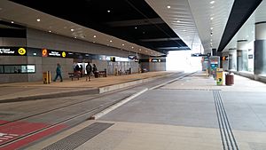
Most of the eighteen stations are at street level with open-air shelters. One station, Gold Coast University Hospital, is underground. Eleven stations have platforms on the side, and eight have platforms in the middle.
Seven stations allow you to transfer to Translink bus services. There are also "park & ride" facilities at Helensvale and Parkwood stations. This means you can park your car and then take the tram. Parkwood has 1000 parking spaces, and Helensvale has 400 new spaces, plus 877 existing ones.
| Transfer station to Translink bus services | |
| Transfer station to Translink bus services and to the Gold Coast railway line |
| Station | Suburb | Zone | Opened | Grade | Platform layout | Time | Refs. |
|---|---|---|---|---|---|---|---|
| Helensvale |
Helensvale | 5 | 17 December 2017 | Street-level | Island | 0 | |
| Parkwood | Parkwood | 5 | 17 December 2017 | Street-level | Side | 4 | |
| Parkwood East | Parkwood | 5 | 17 December 2017 | Street-level | Island | 7 | |
| Gold Coast University Hospital |
Southport | 5 | 20 July 2014 | Underground | Side | 11 | |
| Griffith University |
Southport | 5 | 20 July 2014 | Street-level | Side | 13 | |
| Queen Street | Southport | 5 | 20 July 2014 | Street-level | Island | 16 | |
| Nerang Street | Southport | 5 | 20 July 2014 | Street-level | Side | 19 | |
| Southport |
Southport | 5 | 20 July 2014 | Street-level | Side | 21 | |
| Southport South | Southport | 5 | 20 July 2014 | Street-level | Island | 23 | |
| Broadwater Parklands | Southport | 5 | 20 July 2014 | Street-level | Island | 24 | |
| Main Beach | Main Beach | 5 | 20 July 2014 | Street-level | Island | 26 | |
| Surfers Paradise North |
Surfers Paradise | 5 | 20 July 2014 | Street-level | Side | 29 | |
| Cypress Avenue |
Surfers Paradise | 5 | 20 July 2014 | Street-level | Side | 31 | |
| Cavill Avenue | Surfers Paradise | 5 | 20 July 2014 | Street-level | Side | 34 | |
| Surfers Paradise | Surfers Paradise | 5 | 20 July 2014 | Street-level | Side | 36 | |
| Northcliffe | Surfers Paradise | 5 | 20 July 2014 | Street-level | Side | 38 | |
| Florida Gardens | Surfers Paradise | 5 | 20 July 2014 | Street-level | Island | 40 | |
| Broadbeach North | Broadbeach | 5 | 20 July 2014 | Street-level | Island | 42 | |
| Broadbeach South |
Broadbeach | 5 | 20 July 2014 | Street-level | Side | 45 |
Using G:link
Keolis Downer operates the G:link services. Fares are set by Translink. All stations have "go card" readers for easy payment. A flat rate applies across all zones. All G:link stations are in zone 5.
Trams run very often, especially during the day.
| Weekdays | Weekends | |
|---|---|---|
| 00:00 to 05:00 | Closed | 30† |
| 05:00 to 07:00 | 15 | 15 |
| 07:00 to 19:00 | 7.5 | 10 |
| 19:00 to 23:30 | 15 | 15 |
† No service between Helensvale station and Gold Coast University Hospital
Early in the morning on weekdays (midnight to 5 am), buses replace most tram services. These buses do not go between Helensvale station and Gold Coast University Hospital.
How Many People Ride G:link?
More than 1.74 million passengers used the G:link in its first 100 days. Over five million paid trips were made in the first nine months. In its first year, 6.6 million passengers rode the line. The total number of public transport users on the Gold Coast (buses and trams) went up by 25%.
In February 2016, the Queensland Government announced that ten million passengers had used the G:link. Cavill Avenue was the busiest station, with about 4,729 people boarding each day.
The G:link is a very popular way to travel on the Gold Coast. In 2018–19, it carried 10.74 million passengers. This made up 35% of all public transport trips on the Gold Coast.
| Year | 2014–15 | 2015–16 | 2016–17 | 2017–18 | 2018–19 | 2019–20 | 2020–21 | 2021–22 | 2022–23 | |
|---|---|---|---|---|---|---|---|---|---|---|
| Patronage (millions) |
6.28 |
7.68 | 7.97 | 9.49 |
10.74 | 8.46 |
6.12 |
6.34 |
10.39 | |
| Reference | ||||||||||
|
Bus (46%) Light rail (35%) Heavy rail (19%) |
|
| Bus | 14 000 000 |
| Light rail | 10 740 000 |
| Heavy rail | 5 800 000 |
More Possible Extensions
The Gold Coast City Council has big plans for the light rail network. They imagine a system with 68 km (42 mi) of track and 4 light rail lines. This is part of their City Transport Strategy 2031. These future extensions will likely happen after Stage 4 to Gold Coast Airport is finished.
Main Beach and The Spit
A short line from Main Beach to The Spit has been suggested. This line would be about 2.6 km (1.6 mi) long.
Biggera Waters
Another idea is an extension to Biggera Waters. This line would branch off from the University Hospital station. It would travel north to Harbour Town Shopping Centre.
Bundall
An extension to Bundall is also being considered. This line would go west from Cavill Avenue. It might include stops at Chevron Island, HOTA, and the Gold Coast Turf Club.
Nerang
A possible extension to Nerang could branch from Broadbeach. It would travel west and then north, ending at the Nerang railway station. Stops might include Mermaid Waters and Carrara Markets.
Robina
A 9 km (5.6 mi) extension to Robina is proposed. This line would branch from Nobbys Beach. It would end at Robina railway station, passing by Bond University and Robina Town Centre.
Varsity Lakes
An extension to Varsity Lakes from Burleigh Heads is also planned. This line would follow Burleigh Connection Road. It would pass by Stocklands Burleigh Heads Shopping Centre and end at Varsity Lakes railway station, connecting to the heavy rail.
Tweed Heads
There are plans to extend the G:link from the Gold Coast Airport across the New South Wales border into Tweed Heads. Funding was provided in August 2020 to study this idea.
 | Frances Mary Albrier |
 | Whitney Young |
 | Muhammad Ali |


